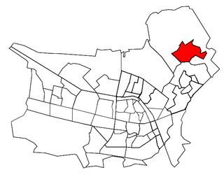
Spaubeek is a village in the Dutch province of Limburg. It is located in the municipality of Beek, about 3 km south of the town of Geleen. Spaubeek was a separate municipality until 1982, when it was merged with Beek.
Gemert is a town in the Dutch province of North Brabant. It is located in the municipality of Gemert-Bakel.
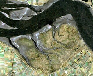
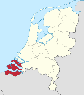
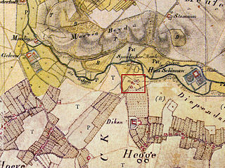
Saeftinghe or Saaftinge was a town in the southwest Netherlands, located in eastern Zeelandic Flanders, near Nieuw-Namen. It existed until 1584. It is now a swamp known as the Drowned Land of Saeftinghe and an official nature reserve area. The land is a crosspoint where the river Scheldt meets the salty waters of the North Sea in the estuary Western Scheldt. It is a treacherous place where the tides easily consume large stretches of land in a matter of seconds and must not be explored without an experienced guide.
Nieuwland is the name of several Dutch villages:
Nieuwland is a former municipality in the Dutch province of Zeeland. It existed until 1816, when it was merged with Sint Joosland to form the new municipality of Nieuw- en Sint Joosland.
Rengerskerke en Zuidland is a former municipality in the Dutch province of Zeeland. It existed until 1813, when it was merged with Kerkwerve.

Sint Laurens is a village in the Dutch province of Zeeland. It is located in the municipality of Middelburg, about 3 km north of the city.

Roggel is a village in the Dutch province of Limburg. It is located in the municipality of Leudal.
Cuijk en Sint Agatha is a former municipality in the Dutch province of North Brabant. It covered the villages of Cuijk and Sint Agatha.
Ginneken en Bavel was a municipality in the Dutch province of North Brabant, located southeast of the city of Breda. It covered the villages of Ginneken and Bavel.
Oploo, Sint Anthonis en Ledeacker was a municipality in the Dutch province of North Brabant. It was created in 1821, in a merger of Oploo and Sint Anthonis en Ledeacker. The municipality existed until 1994, when it became part of a larger municipality St. Anthonis.

Oud- en Nieuw-Gastel was a municipality in the Dutch province of North Brabant. It covered the villages of Oud Gastel, located 7 km north of Roosendaal, and Stampersgat.
Sint Anthonis en Ledeacker was a municipality in the Dutch province of North Brabant. It consisted of the villages Sint Anthonis and Ledeacker.
Udenhout is a village and a former municipality in the Dutch province of North Brabant. It is located northeast of Tilburg, north of Berkel-Enschot and south of the National Parc Loonse en Drunense Duinen.
Nieuw-Helvoet is a former village in the Dutch province of South Holland. It is now a neighbourhood in the north of the town of Hellevoetsluis.
Bavel is a village in the southern Netherlands. It is located in the Dutch province of North Brabant, largely within the municipality of Breda with some rural areas in the municipality of Alphen-Chaam.
Oude en Nieuwe Struiten is a former municipality in the Dutch province of South Holland. It consisted of a small polder east of Hellevoetsluis, and is now covered by the suburbs Wittenshoeck and De Struyten of that city.

St. Bernard's Abbey, Hemiksem, or abbatiae S. Bernardi ad Scaldim, ordinis Cisterciensis, in dioecesi Antverpiensi also known as St. Bernard's Abbey on the Scheldt, located in Hemiksem in the province of Antwerp in Belgium, was a Cistercian monastery founded in 1243 and dissolved during the French Revolution. The buildings are now the property of the municipality of Hemiksem.

Oldambt is a municipality with a population of 38,057 in the province of Groningen in the Netherlands. It was established in 2010 by merging the municipalities of Reiderland, Scheemda, and Winschoten. It contains the city of Winschoten and the villages Bad Nieuweschans, Beerta, Blauwestad, Drieborg, Finsterwolde, Heiligerlee, Midwolda, Nieuw-Beerta, Nieuwolda, Nieuw-Scheemda, Oostwold, Scheemda, 't Waar, and Westerlee. The mayor was Pieter Smit of D66.