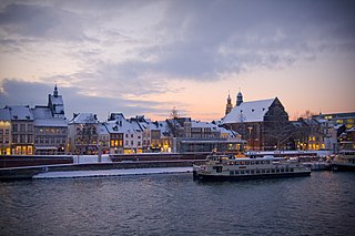
Maastricht is a city and a municipality in the southeastern Netherlands. It is the capital and largest city of the province of Limburg. Maastricht is located on both sides of the Meuse, at the point where the river is joined by the Jeker. Mount Saint Peter (Sint-Pietersberg) is largely situated within the city's municipal borders. Maastricht is adjacent to the border with Belgium and is part of the Meuse-Rhine Euroregion, an international metropolis with a population of about 3.9 million, which includes the nearby German and Belgian cities of Aachen, Liège, and Hasselt.

Maaseik is a city and municipality in the Belgian province of Limburg. Both in size and in population, it is the 8th largest municipality in Limburg. The town is the seat of the administrative arrondissement of Maaseik (kieskanton). Internationally, Maaseik is known as the assumed birthplace of the famous Flemish painters Jan and Hubert van Eyck.
Geleen is a city in the southern part of the province of Limburg in the Netherlands. With 31,670 inhabitants in 2020, it is part of the municipality of Sittard-Geleen. Geleen is situated along the river Geleenbeek, a right tributary to the river Meuse. The Latin name for Geleenbeek is Glana, meaning "clear river". The town centre is situated at about 60 m above sea level.

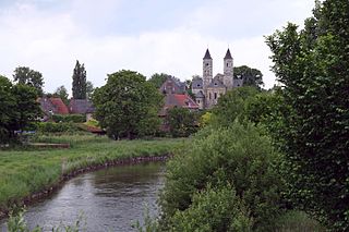
Houthem is a village in the Dutch province of Limburg. It is a part of the municipality of Valkenburg aan de Geul, and lies about 8 km east of Maastricht.

Bronkhorst is a village in the municipality of Bronckhorst, Gelderland, the Netherlands. Technically, it is a city and, with only 157 inhabitants (2010), one of the smallest cities in the Netherlands.

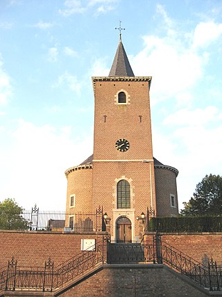
Spaubeek is a village in the Dutch province of Limburg. It is located in the municipality of Beek, about 3 km south of the town of Geleen. Spaubeek was a separate municipality until 1982, when it was merged with Beek.

Reuver is a village in the Dutch province of Limburg. It is located in the municipality of Beesel, about 10 km south of the city of Venlo. The successful metal band Epica comes from Reuver.

Gemert is a town in the Dutch province of North Brabant. It is located in the municipality of Gemert-Bakel.
Sint Odiliënberg is a village in southeast Netherlands, It is located in Roerdalen, Limburg, in the Roer River valley.

Operation Blackcock was an operation to clear German troops from the Roer Triangle, formed by the towns of Roermond and Sittard in the Netherlands and Heinsberg in Germany during the fighting on the Western Front in the Second World War. It was conducted by the British Second Army between 13 and 26 January 1945. The objective was to drive the German 15th Army back across the rivers Roer and Wurm and move the frontline further into Germany. The operation was carried out by Lieutenant-General Neil Ritchie's XII Corps by three divisions: the 7th Armoured Division, the 43rd (Wessex) Infantry Division and the 52nd (Lowland) Infantry Division. The operation, named after the Scottish male black grouse, is relatively unknown.

Echt is a city in the Dutch municipality of Echt-Susteren in the province of Limburg, Netherlands. It was a municipality itself until it merged with the municipality of Susteren on 1 January 2003.

Nunhem is a village in the Dutch province of Limburg. It is located in the municipality of Leudal, 1 km north of Haelen.

Posterholt is a village in the Dutch province of Limburg. It is located in the municipality of Roerdalen.

Sint Geertruid is a village in the Dutch province of Limburg. It is located the municipality of Eijsden-Margraten.
Wijnandsrade is a village in the Dutch province of Limburg. It is located in the municipality of Beekdaelen. It is notable for its castle and church and two ponds, which define the village's centre.

Babyloniënbroek is a village in the Dutch province of North Brabant. It is in the municipality of Altena, about 7 km northwest of the city of Waalwijk.

Eys is a village in the municipality of Gulpen-Wittem, Limburg, the Netherlands. The town is located 3 km. from Gulpen and 17 km. from provincial capital Maastricht. Furthermore, it is characterised by its location in the hilly landscape of South Limburg. The village was first mentioned in 1193 in a document of the Sint-Pauluskapittel of Liège, Belgium, and was named after the river Eyserbeek.
Velm is one of the ancienne communes in the municipality of Sint-Truiden, Limburg province, Belgium.

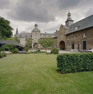
Château St. Gerlach, formerly St. Gerlach Monastery or Sint-Gerlachusstift, is located in the church village of Houthem in Valkenburg aan de Geul in the valley of the Geul river, in the province of Limburg, Netherlands. It was originally built in the twelfth century as a monastery of canons and functioned from the fourteenth century as noble ladies convent. In the nineteenth century, the monastery was converted into a castle-like country house. It includes a rectangular main building, a coach house and a castle farm. Since 1997, the complex at Joseph Corneli Allee has been a luxurious hotel, restaurant and conference center established. The building complex, including the Sint-Gerlachus Church and the surrounding gardens, includes several national monuments and is part of the Buitengoed Geul & Maas.

Genhout is a village in the Dutch province of Limburg. It is located in the municipality of Beek, and consists of two former settlements: the village Groot Genhout and the hamlet Klein Genhout. Since 2005, the two settlements are no longer distinguished. It is located about 13 kilometres (8.1 mi) north-east of Maastricht.


