Sippar-Amnanum

Last updated
Sippar-Amnanum
Iraq physical map.svg
Archaeological site icon (red).svg
Shown within Iraq
Alternative nameTell ed-Der
Location Baghdad Governorate, Iraq
Coordinates 33°05′57″N44°17′50″E / 33.09917°N 44.29722°E / 33.09917; 44.29722
Typesettlement
History
PeriodsBronze Age, Iron Age
Site notes
Excavation dates1878-80, 1941, 1968-1988
ArchaeologistsHormuzd Rassam, Taha Baqir, L. De Meyer, M. H. Gasche
ConditionRuined
OwnershipPublic
Public accessYes

Sippar-Amnanum (also Sippar-Annunitum, Sippar-rabum, Sippar-durum, and Sippar-Anunit ), modern Tell ed-Der (also Teil ed-Der) in Baghdad Governorate, Iraq, was an ancient Near Eastern city about 70 kilometers north of Babylon, 6 kilometers northeast of Sippar and about 26 kilometers southwest of modern Baghdad. Occupation dates back to the days of the Akkadian Empire and later the Ur III period but most of the development was during the Old Babylonian period. Early archaeologists referred to the site as "Der" or Dair". In the late 1800s archaeologists proposed that this was the location of the city of Akkad, later disproved. [1]

Contents

History

Sippar-Amnanum was the sister city (or suburb in some eyes) of Sippar. Though occupied from the Akkadian Period, little is known of its history before the Old Babylonian period. [2] Soundings have shown that occupation extends to 4 meters below the surface with the current water table at 2 meters making excavation of earlier occupation difficult. The oldest excavated layer of Level IV, dating from the Ur III period, of which foundations are apparent. [3] [4]

The chief deity of Sippar-Amnanum was Annunitum, a warlike aspect of Ishtar favored by the Akkadians. She is the daughter of Enlil. According to the Sippar Cylinder of Nabonidus the temple Eulmash of Anunitu (Amnanum) was rebuilt by that Neo-Babylonian king. The cylinder also reports that the temple had earlier been rebuilt by Shagarakti-Shuriash (c, 1245–1233 BC, a king of the Kassite dynasty of Babylon (having earlier been rebuilt by Kassite ruler Kurigalzu I), Nabonidus having found one of the original foundation Kassite foundation cylinders.

"For Annunītu, lady of Emaš of Sippar-Annunītu, his lady, Šagarakti-Šuriaš, the shepherd, favorite of Šamaš, beloved of Annunītu, [(did building work on)] Emaš, her beloved temple, the temple that had become dilapidated long ago, which Kurigalzu, son of Kadašman-Ḫarbe, his forefather from bygone days, had made new and also consolidated (but) whose walls through aging had fallen and bowed like a curved staff (…). He raised(?) … He raised(?) … He raised the top of its walls like the mountains. He restored this temple to its place.” For Ištar-Annunītu, his lady, Kurigalzu, governor for Enlil, built Emaš, the old dwelling [place](?) / her beloved [temple] that had become dilapidated a long time ago. [Indeed] he restored it to [its place]. [According to the text of a fo]undation deposit of Emaš of Sippar-Annun[ītu]." [5]

Presumably the temple had been destroyed in the interim by Shutruk-Nakhkhunte of Elam when he destroyed Sippar. [6] There was also a temple of Shamash in Sippar-Amnanum named Edikuda. [7]

Note that there is some confusion on the city's name since Sîn-kāšid, a king of Uruk, refers to himself in an inscription as "King of the Amnanum", where Amnanum is thought to be a tribal group. [8]

Archaeology

Babylonia at the time of Hammurabi, c. 1792-1750 BC Basse Mesopotamie PB.PNG
Babylonia at the time of Hammurabi, c.1792-1750 BC

The site covers around 51 hectares with an east and west tell divided by an ancient canal bed. Sippar-Amnanum was surrounded by a 3 kilometer large defensive wall much of which still remains. Tell ed-Der, along with Sippar, was excavated by Hormuzd Rassam between 1878 and 1880. [9] Most of the tablets ended up in the British Museum. As was often the case in the early days of archaeology, excavation records were not made, particularly find spots. This makes it occasionally difficult to tell which tablets came from Sippar-Amnanum as opposed to Sippar. [10] More Tell ed-Der tablets were purchased from locals by E. A. Wallis Budge while he was in the region after brief attempts to dig there in 1891. [11] In the 1930s the German archaeologists Walter Andrae and Julius Jordan visited the site and produced the first maps. [12]

A sounding was conducted there between 1940 and 1941 by the Directorate General of Antiquities of the Iraqi Government under the direction of Taha Baqir. [13] Among their finds were the archives of Anum-pisha and Iku-pish (dating to the time of Bablonian rulers Sumu-abum and Sumu-la-El). [14] Three hundred broken cuneiform tablets from the Old Babylonian period were found. [15] [16] Since the site is relatively close to Baghdad, it was a popular target for illegal excavations. [11] More recently, Tell ed-Der was excavated in a number of seasons between 1968 and 1988 by the Belgian Archaeological Expedition to Iraq (Comite Belge de Recherches Historiques en Mesopotamie) led by L. De Meyer and M. H. Gasche. [17] [18] [19] [20] [21]

The "House of Ur-Utu" was excavated in the mid 1970s. This residence, of the kalamahhum-priest (lamentation priest) of Annunitum, held around 2500 cuneiform tablets and tablet fragments forming a household archive spanning several centuries. Of these 204 were of Ur-Utu (and his father Inanna-mansum). [22] The destruction of the house by fire helped preserve the tablets. [23] [24] Most of the tablets were contemporary with the reigns of Ammisaduqa and Ammi-ditana of the First Babylonian dynasty. [25] [26] A number of cuneiform tablets from "uncontrolled digging" at Sippar-Amnanum have appeared in various museums, beginning in the late 1800s. [27]

In the dromos of chamber tomb T. 272, four equid legs together with some pig and ox remains were found. [28]

See also

Related Research Articles

Ur was an important Sumerian city-state in ancient Mesopotamia, located at the site of modern Tell el-Muqayyar in Dhi Qar Governorate, southern Iraq. Although Ur was once a coastal city near the mouth of the Euphrates on the Persian Gulf, the coastline has shifted and the city is now well inland, on the south bank of the Euphrates, 16 km (10 mi) from Nasiriyah in modern-day Iraq. The city dates from the Ubaid period c. 3800 BC, and is recorded in written history as a city-state from the 26th century BC, its first recorded king being King Tuttues.

Eridu was a Sumerian city located at Tell Abu Shahrain, also Abu Shahrein or Tell Abu Shahrayn, an archaeological site in southern Mesopotamia. It is located in Dhi Qar Governorate, Iraq near the modern city of Basra. Eridu is traditionally believed to be the earliest city in southern Mesopotamia based on the Sumerian King List. Located 12 kilometers southwest of the ancient site of Ur, Eridu was the southernmost of a conglomeration of Sumerian cities that grew around temples, almost in sight of one another. The city gods of Eridu were Enki and his consort Damkina. Enki, later known as Ea, was considered to have founded the city. His temple was called E-Abzu, as Enki was believed to live in Abzu, an aquifer from which all life was believed to stem. According to Sumerian temple hymns another name for the temple of Ea/Enki was called Esira (Esirra).

"... The temple is constructed with gold and lapis lazuli, Its foundation on the nether-sea (apsu) is filled in. By the river of Sippar (Euphrates) it stands. O Apsu pure place of propriety, Esira, may thy king stand within thee. ..."

<span class="mw-page-title-main">Larsa</span> City-state in ancient Sumer

Larsa, also referred to as Larancha/Laranchon by Berossos and connected with the biblical Ellasar, was an important city-state of ancient Sumer, the center of the cult of the sun god Utu with his temple E-babbar. It lies some 25 km (16 mi) southeast of Uruk in Iraq's Dhi Qar Governorate, near the east bank of the Shatt-en-Nil canal at the site of the modern settlement Tell as-Senkereh or Sankarah.

Sippar was an ancient Near Eastern Sumerian and later Babylonian city on the east bank of the Euphrates river. Its tell is located at the site of modern Tell Abu Habbah near Yusufiyah in Iraq's Baghdad Governorate, some 69 km (43 mi) north of Babylon and 30 km (19 mi) southwest of Baghdad. The city's ancient name, Sippar, could also refer to its sister city, Sippar-Amnanum ; a more specific designation for the city here referred to as Sippar was Sippar-Yahrurum.

<span class="mw-page-title-main">Kassites</span> People of the ancient Near East

The Kassites were people of the ancient Near East, who controlled Babylonia after the fall of the Old Babylonian Empire c. 1531 BC and until c. 1155 BC.

<span class="mw-page-title-main">Shamash</span> Mesopotamian sun god

Shamash, also known as Utu was the ancient Mesopotamian sun god. He was believed to see everything that happened in the world every day, and was therefore responsible for justice and protection of travelers. As a divine judge, he could be associated with the underworld. Additionally, he could serve as the god of divination, typically alongside the weather god Adad. While he was universally regarded as one of the primary gods, he was particularly venerated in Sippar and Larsa. The moon god Nanna (Sin) and his wife Ningal were regarded as his parents, while his twin sister was Inanna (Ishtar). Occasionally other goddesses, such as Manzat and Pinikir, could be regarded as his sisters too. The dawn goddess Aya (Sherida) was his wife, and multiple texts describe their daily reunions taking place on a mountain where the sun was believed to set. Among their children were Kittum, the personification of truth, dream deities such as Mamu, as well as the god Ishum. Utu's name could be used to write the names of many foreign solar deities logographically. The connection between him and the Hurrian solar god Shimige is particularly well attested, and the latter could be associated with Aya as well.

Isin (Sumerian: 𒉌𒋛𒅔𒆠, romanized: I3-si-inki, modern Arabic: Ishan al-Bahriyat) is an archaeological site in Al-Qādisiyyah Governorate, Iraq which was the location of the Ancient Near East city of Isin, occupied from the late 4th millennium Uruk period up until at least the late 1st millennium BC Neo-Babylonian period. It lies about 40 km (25 mi) southeast of the modern city of Al Diwaniyah.

<span class="mw-page-title-main">Dur-Kurigalzu</span> Archaeological site in Iraq

Dur-Kurigalzu was a city in southern Mesopotamia, near the confluence of the Tigris and Diyala rivers, about 30 kilometres (19 mi) west of the center of Baghdad. It was founded by a Kassite king of Babylon, Kurigalzu I and was abandoned after the fall of the Kassite dynasty. The city was of such importance that it appeared on toponym lists in the funerary temple of the Egyptian pharaoh, Amenophis III at Kom el-Hettan". The prefix Dur is an Akkadian term meaning "fortress of", while the Kassite royal name Kurigalzu is believed to have meant "shepherd of the Kassites". The tradition of naming new towns Dur dates back to the Old Babylonian period with an example being Dūr-Ammī-ditāna. The city contained a ziggurat and temples dedicated to Mesopotamian gods, as well as a royal palace which covered 420,000 square meters.

<span class="mw-page-title-main">Kassite dynasty</span> Babylonian kings

The Kassite dynasty, also known as the third Babylonian dynasty, was a line of kings of Kassite origin who ruled from the city of Babylon in the latter half of the second millennium BC and who belonged to the same family that ran the kingdom of Babylon between 1595 and 1155 BC, following the first Babylonian dynasty. It was the longest known dynasty of that state, which ruled throughout the period known as "Middle Babylonian".

Shullat (Šûllat) and Hanish (Ḫaniš) were a pair of Mesopotamian gods. They were usually treated as inseparable, and appear together in various works of literature. Their character was regarded as warlike and destructive, and they were associated with the weather.

<span class="mw-page-title-main">Nazi-Maruttash</span> King of Babylon

Nazi-Maruttaš, typically inscribed Na-zi-Ma-ru-ut-ta-aš or mNa-zi-Múru-taš, Maruttašprotects him, was a Kassite king of Babylon c. 1307–1282 BC and self-proclaimed šar kiššati, or "King of the World", according to the votive inscription pictured. He was the 23rd of the dynasty, the son and successor of Kurigalzu II, and reigned for twenty six years.

Marad was an ancient Near Eastern city. Marad was situated on the west bank of the then western branch of the Upper Euphrates River west of Nippur in modern-day Iraq and roughly 50 km southeast of Kish, on the Arahtu River. The site was identified in 1912 based on a Neo-Babylonian inscription on a truncated cylinder of Nebuchadrezzar noting the restoration of the temple. The cylinder was not excavated but rather found by locals so its provenance was not certain, as to some extent was the site's identification as Marad. In ancient times it was on the canal, Abgal, running between Babylon and Isin.

Dilbat was an ancient Near Eastern city located 25 kilometers south of Babylon on the eastern bank of the Western Euphrates in modern-day Babil Governorate, Iraq. It lies 15 kilometers southeast of the ancient city of Borsippa. The site of Tell Muhattat, 5 kilometers away, was earlier thought to be Dilbat. The ziggurat E-ibe-Anu, dedicated to Urash, a minor local deity distinct from the earth goddess Urash, was located in the center of the city and was mentioned in the Epic of Gilgamesh.

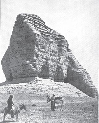
Tell al-Lahm is an archaeological site in Dhi Qar Governorate (Iraq). It is 38 km (24 mi) southeast of the site of ancient Ur. Its ancient name is not known with certainty with Kuara, Kisig, and Dur-Iakin having been proposed. The Euphrates River is 256 km (159 mi) away but in antiquity, or a branch of it, ran by the site, continuing to flow until the Muslim Era.

<span class="mw-page-title-main">Kurigalzu I</span> King of Babylon in the early 1300s BC

Kurigalzu I, usually inscribed ku-ri-gal-zu but also sometimes with the m or d determinative, the 17th king of the Kassite or 3rd dynasty that ruled over Babylon, was responsible for one of the most extensive and widespread building programs for which evidence has survived in Babylonia. The autobiography of Kurigalzu is one of the inscriptions which record that he was the son of Kadašman-Ḫarbe. Galzu, whose possible native pronunciation was gal-du or gal-šu, was the name by which the Kassites called themselves and Kurigalzu may mean Shepherd of the Kassites.

Adad-apla-iddina, typically inscribed in cuneiform mdIM-DUMU.UŠ-SUM-na, mdIM-A-SUM-na or dIM-ap-lam-i-din-[nam] meaning the storm god “Adad has given me an heir”, was the 8th king of the 2nd Dynasty of Isin and the 4th Dynasty of Babylon and ruled c. 1064–1043. He was a contemporary of the Assyrian King Aššur-bêl-kala and his reign was a golden age for scholarship.

<span class="mw-page-title-main">Akkad (city)</span> Ancient Mesopotamian city

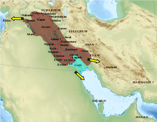
Akkad was the capital of the Akkadian Empire, which was the dominant political force in Mesopotamia during a period of about 150 years in the last third of the 3rd millennium BC.

<span class="mw-page-title-main">Enlil-bānī land grant kudurru</span> Ancient Mesopotamian clay stele

The Enlil-bānī land grant kudurru is an ancient Mesopotamian narû ša ḫaṣbi, or clay stele, recording the confirmation of a beneficial grant of land by Kassite king Kadašman-Enlil I or Kadašman-Enlil II to one of his officials. It is actually a terra-cotta cone, extant with a duplicate, the orientation of whose inscription, perpendicular to the direction of the cone, in two columns and with the top facing the point, indicates it was to be erected upright,, like other entitlement documents of the period.

<span class="mw-page-title-main">Annunitum</span> Mesopotamian goddess

Annunitum was a Mesopotamian goddess associated with warfare. She was initially an epithet of Ishtar of Akkad exemplifying her warlike aspect, but by the late third millennium BCE she came to function as a distinct deity. She was the tutelary goddess of the cities of Akkad and Sippar-Amnanum, though she was also worshiped elsewhere in Mesopotamia.

Tell Muhammad, is an ancient Near East archaeological site currently in the outskirts of Baghdad, along the Tigris river in the Diyala region. It is a very short distance from the site of Tell Harmal to the north and not far from the site of Tell al-Dhiba'i to the northeast. The ancient name of the site is unknown though Diniktum has been suggested. The lost city of Akkad has also been proposed. Based on a year name found on one of the cuneiform tablets the name Banaia has also been proposed.

References

  1. Naohiko Kawakami, "The Location of the Ancient City of Akkade: Review of Past Theories and Identification of Issues for Formulating a Specific Methodology for Searching Akkade", AL-RĀFIDĀN: Journal of Western Asiatic Studies, vol. 45, pp. 45–68, 2023
  2. Mahmood, Lina, "Two Cities of Sippar: Tell Abu-Habbah and Tell ed-Der", Masters Dissertation, The Graduate School, Stony Brook University: Stony Brook, NY, 2006
  3. "Excavations in Iraq 1973-74", Iraq, vol. 37, no. 1, pp. 56–67, 1975
  4. "Excavations in Iraq, 1976", Iraq, vol. 39, no. 2, pp. 300–20, 1977
  5. Alexa Bartelmus, and Jon Taylor, "Collecting And Connecting History: Nabonidus and the Kassite Rebuilding of E(ul)maš of (Ištar)-Annunītu in Sippar-Annunītu", Journal of Cuneiform Studies, vol. 66, pp. 113–28, 2014
  6. Schaudig, Hanspeter, "Die Inschriften Nabonids von Babylon und Kyros’ des Großen samt den in ihrem Umfeld entstandenen Tendenzschriften: Textausgabe und Grammatik", Alter Orient und Altes Testament 256. Münster: Ugarit-Verlag, 2001
  7. Tanret, Michel, "The seal of the sanga: on the Old Babylonian sangas of Šamaš of Sippar-Jaḫrūrum and Sippar-Amnānum" Vol. 40. Brill, 2010 ISBN   978-9004179585
  8. Foster, Benjamin R., and Elizabeth E. Payne, "Cuneiform Tablets from Mount Holyoke College", Orientalia, vol. 81, no. 4, pp. 277–317, 2012
  9. Hormuzd Rassam, "Asshur and the land of Nimrod; being an account of the discoveries made in the ancient ruins of Nineveh, Asshur, Sepharvaim, Calah [etc.]", New York : Eston & Mains, 1897
  10. Anne Goddeeris, "Economy and Society in Northern Babylonia in the Early Old Babylonian Period", Peeters Publishers, 2002, ISBN   90-429-1123-9
  11. 1 2 Budge, E. A. W., and e. al., "By Nile and Tigris: A narrative of Journeys in Egypt and Mesopotamia on Behalf of the British Museum between the Years 1886-1913", Vol. 1 London: John Murray, 1920
  12. Andrae, W., and J. Jordan, "Abu Habbah-Sippar", Iraq 1, pp. 51-59, 1934
  13. Baqir, T., Mustafa, M., "Iraq Government Sounding at Der", Sumer, Vol 1, pp. 37-54, 1945 (in Arabic)
  14. de Boer, Rients, "The Ikun-pisa Letter Archive from Tell ed-Der: IPLA", Vol. 131. ISD LLC, 2021 ISBN   9789042943162
  15. Dietz Otto Edzard, Altbabylonische Rechts-und Wirtschaftsurkunden aus Tell ed-Der im Iraq Museum, Baghdad, Bayerischen Akademie, 1970
  16. Khalid al-A'dami, "Old Babylonian Letters from ed-Der", Sumer, vol. 23, pp. 151-165 and plates 1-17, 1967
  17. "Excavations in Iraq 1972-73", Iraq, vol. 35, no. 2, pp. 188–204, 1973
  18. Gasche Hermann and Paepe Roland De Meyer Léon, "Tell ed-der I: rapport préliminaire sur la première campagne (février 1970) / Voorlopig verslag over de eerste campagne", Leuven, 1971
  19. L. de Meyer, "La sixieme campagne de fouilles a Tell ed-Deir", Sumer, vol. 32, pp. 161-165, 1974
  20. "Excavations in Iraq, 1979-80", Iraq, vol. 43, no. 2, pp. 167–98, 1981
  21. "Excavations in Iraq 1973-74", Iraq, vol. 37, no. 1, pp. 56–67, 1975
  22. Janssen, Caroline, "Address Behaviour in Eight Unpublished ana bēlīja Letters from the Late Old Babylonian Ur-Utu Archive: Close Relatives Through a Distant Mirror?", Zeitschrift für Assyriologie und vorderasiatische Archäologie, vol. 108, no. 2, pp. 149-166, 2018
  23. "Excavations in Iraq 1975", Iraq, vol. 38, no. 1, pp. 65–79, 1976
  24. "Excavations in Iraq, 1977-78", Iraq, vol. 41, no. 2, pp. 141–81, 1979
  25. Karel Van Lerberghe and Gabriella Voet, "Sippar-Amnanum The Ur-Utu Archive", (Mesopotamian History and Environment, Series III, Texts, 1), Ghent, The University of Ghent, 1991
  26. Michel Tanret, "Sippar-Amnănum : the Ur-Utu archive / Tome 2, Per aspera ad astra : l'apprentissage du cunéiforme à Sippar-Amnănum pendant la période", Université de Gand, Gand, 2002
  27. Kalla, G., "Die Geschichte der Entdeckung der altbabylo-nischen Sippar-Archive", ZA89, pp. 201–226, 1999
  28. Gasche, H., "La Babylonie au 17ème siècle avant notre ère. Approche archéologique, problèmes et perspectives", [=Mesopotamian History and Environment. Series ii, Memoirs 1], Ghent: University of Ghent, 1989

Further reading