
Southern Finland was a province of Finland from 1997 to 2009. It bordered the provinces of Western Finland and Eastern Finland. It also bordered the Gulf of Finland and Russia.
Nurmijärvi is the most populated rural municipality of Finland, located 37 kilometres (23 mi) north of the capital Helsinki. The neighboring municipalities of Nurmijärvi are Espoo, Vantaa, Tuusula, Hyvinkää and Vihti, and it is part of the Greater Helsinki. The population of the municipality is 44,616 inhabitants. In recent decades, it has been one of the fastest growing municipalities in the Greater Helsinki and also in whole Finland in terms of population. The close proximity to Helsinki has led to a considerable growth of the major villages such as Klaukkala, Rajamäki and Röykkä. Klaukkala is the biggest built-up area of Nurmijärvi, which nowadays is considered a dormitory town of Helsinki. The Nurmijärvi church village (Kirkonkylä) is the administrative centre of the municipality, although the clear emphasis on population growth is in Klaukkala.

Elimäki is a former municipality of Finland.

Anjalankoski is a former town and municipality of Finland. It had 16 379 inhabitants in 2008. About 4/5 of the people live in the vicinity of the Kymi River. The most densely populated communities are Myllykoski and Inkeroinen. In addition, there is plenty of countryside.

Kouvola is a city and municipality in southeastern Finland. It is located along the Kymijoki River in the region of Kymenlaakso, 62 kilometres (39 mi) kilometers east of Lahti, 87 kilometres (54 mi) west of Lappeenranta and 134 kilometres (83 mi) northeast of the capital, Helsinki. With Kotka, Kouvola is one of the capital centers and is the largest city in the Kymenlaakso region.
The 7 municipalities of the Kymenlaakso Region in Finland are divided on two sub-regions.

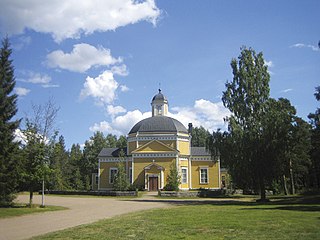
Iitti is a municipality of Finland. It is located in the province of Southern Finland and is part of the Päijänne Tavastia region. The municipality has a population of 6,463 and covers an area of 687.09 square kilometres (265.29 sq mi) of which 97.27 km2 (37.56 sq mi) is water. The population density is 10.96 inhabitants per square kilometre (28.4/sq mi). The administrative center of Iitti is in the village of Kausala.
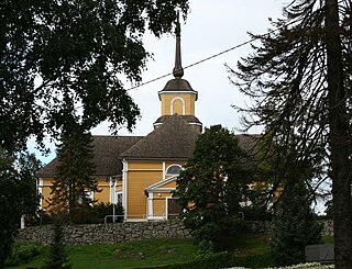
Luumäki is a municipality of Finland. Its seat is in the Taavetti village. It is located in the province of Southern Finland and is part of the South Karelia region. The municipality has a population of 4,424 (19 September 2023) and covers an area of 859.83 square kilometres (331.98 sq mi) of which 109.77 km2 (42.38 sq mi) is water. The population density is 5.9 inhabitants per square kilometre (15/sq mi). The municipality is unilingually Finnish.

Myrskylä is a municipality of Finland. It is located in the Uusimaa region and it is the smallest municipality in the region in relation to its population; the municipality has a population of 1,717 and covers an area of 206.35 square kilometres (79.67 sq mi) of which 5.98 km2 (2.31 sq mi) is water. The population density is 8.57 inhabitants per square kilometre (22.2/sq mi). Neighbouring municipalities are Askola, Porvoo, Pukkila, Orimattila, Lapinjärvi and Loviisa.
Nastola is a former municipality of Finland. It was merged with the city of Lahti on 1 January 2016.

Piippola is a village and a former municipality of Finland.

Myllykosken Pallo -47 is a Finnish football club, based in the industrial village of Myllykoski, part of the city of Kouvola. The club temporarily shut down after having ceased operations in 2015 due to financial difficulties, but returned in 2017 earning a place in the fourth tier and won back-to-back promotions to reach the second division in 2019. It then suffered consecutive relegations in 2020 and 2021, ending up in the fourth-tier Kolmonen.
Utti is a village in Valkeala, since 2009 a part of Kouvola, Finland. In 1918 General Carl Gustaf Mannerheim set up the first Finnish Air Force base in the village. Today, Utti is best known for the Utti Jaeger Regiment, a helicopter base and a training ground for special forces and military police, and civilian skydiving recreational activities.
The Kymi is a river in Finland. It begins at Lake Päijänne, flows through the provinces of Päijänne Tavastia, Uusimaa and Kymenlaakso, and discharges into the Gulf of Finland. The river passes the towns of Heinola and Kouvola. The town of Kotka is located on the river delta. The length of the river is 204 kilometres (127 mi), but its drainage basin of 37,107 square kilometres (14,327 sq mi) extends to almost 600 kilometres (370 mi) inside the Tavastia, Central Finland, Savonia and Ostrobothnia. The furthest source of the river is Lake Pielavesi, its furthest point being some 570 kilometres (350 mi) from the sea measured by flow route. The name of the river, itself, kymi, means "large river", in Old Finnish.

Karhula is a former market town (kauppala) and a former municipality of Finland in the former Kymi Province, now in the Kymenlaakso region. It was consolidated with the town of Kotka in 1977. Its seat was in Helilä, however the municipality was named after the industrial area of Karhula.

Viipuri Province was a historical province of Finland from 1812 to 1945.
The Kymi Province was a province of Finland from 1945 to 1997.
Anjala was a town in Southern Finland, which merged in 1975 with Sippola to form Anjalankoski, later further merged into Kouvola.
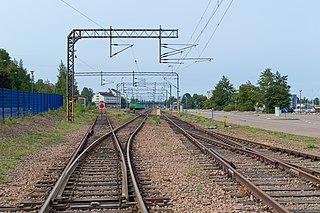
The Kouvola–Kotka railway, also called the Kotka railway is a 1,524 mm railway in Finland, connecting the towns of Kouvola and Kotka in the region of Kymenlaakso.

Haapasaari is an island and a former municipality of Finland in the former Kymi Province, now in the Kymenlaakso region. It was consolidated with the town of Kotka in 1974.


