Related Research Articles

Located in Oceania, Tonga is a small archipelago in the South Pacific Ocean, directly south of Samoa and about two-thirds of the way from Hawaii to New Zealand. It has 169 islands, 36 of them inhabited, which are in three main groups – Vavaʻu, Haʻapai, and Tongatapu – and cover an 800-kilometre (500-mile)-long north–south line. The total size is just 747 km2 (288 sq mi). Due to the spread out islands it has the 40th largest Exclusive Economic Zone of 659,558 km2 (254,657 sq mi).
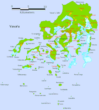
Vavaʻu is an island group, consisting of one large island and 40 smaller ones, in Tonga. It is part of Vavaʻu District, which includes several other individual islands. According to tradition, the Maui god created both Tongatapu and Vavaʻu, but put a little more effort into the former. Vavaʻu rises 204 m (669 ft) above sea level at Mount Talau. The capital is Neiafu, situated at the Port of Refuge.

Haʻapai is a group of islands, islets, reefs, and shoals in the central part of Tonga. It has a combined land area of 109.30 square kilometres (42.20 sq mi). The Tongatapu island group lies to its south, and the Vavaʻu group lies to its north. Seventeen of the Haʻapai islands are inhabited. Their combined population is 5,419. The highest point in the Ha‘apai group, and in all of Tonga, is on Kao, which rises almost 1,050 metres (3,440 ft) above sea level.

The Legislative Assembly of Tonga is the unicameral legislature of Tonga. The assembly has 26 members in which 17 members elected by majority of the people for a 5-year term in multi-seat constituencies via the single non-transferable vote system. There are 9 members elected by the 33 hereditary nobles of Tonga. The Assembly is controlled by the speaker of the House who is elected by majority of the elected members of Parliament and constitutionally appointed by the king.

Totokamaka is an uninhabited island in Tonga. It is located in the southern part of the Vava'u Group in the north of the country. Along with other uninhabited islands in southern Vava'u it has high biodiversity and is an important nesting site for the Green sea turtle and Hawksbill sea turtle.
Totokafonua is an uninhabited island in Tonga. It is located in the southern part of the Vava'u Group in the north of the country. Along with other uninhabited islands in southern Vava'u it has high biodiversity and is an important nesting site for the Green sea turtle and Hawksbill sea turtle.
Avalau, also known as Ovalau, is an island in Tonga, it is located in Motu district within the Vava'u Group, which is in the far north of the country.

Ovaka is an island in Tonga. It is located within the Vava'u Group in the far north of the country. It is 2800 meters long east–west, and more than 800 meters wide at its widest point. The namesake village is located on the northeast coast. The island had a population of 96 in 2021.
Hakaufasi is sand cay in Tonga. It is located within the Vava'u Group in the far north of the country.

Vaimalō, is a village in the western district of Vavaʻu in Tonga. The population is 114.

Falevai is a settlement in the Vava'u islands in Tonga. The name Falevai, if translated into English means "water house." The name was given because of how the seas and the oceans surrounding the houses. Falevai's most famous names are lafa 'i tua and kuli fe kai. The settlement is also part of a 2.29km² Special Management Conservation Area. In 2014, there was a return of the traditional art of tapa-making in the village after decades of it being lost.

The 1981–82 South Pacific cyclone season was a slightly-below average South Pacific tropical cyclone season, with 6 tropical cyclones occurring within the South Pacific Ocean basin between 160°E and 120°W during the season. After this season, the names Gyan and Isaac were retired from the lists of names, after they caused significant impacts to South Pacific island nations.
Tu'anuku is a village on the western part of Vava'u, Tonga. It has several nicknames such as Toa-ko-Tavakefai'ana, Halapukepuke, Hala-siki-'o-Mata'aho and also Uini-e-Ngofe. The population is 298.
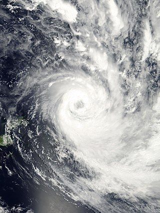
Severe Tropical Cyclone Waka was one of the most destructive tropical cyclones ever to affect the South Pacific Kingdom of Tonga. Waka originated within the near-equatorial trough in mid-December 2001, although the system remained disorganized for more than a week. The storm gradually matured and attained tropical cyclone status on December 29. Subsequently, Waka underwent rapid intensification in which it attained its peak intensity as a Category 4 severe tropical cyclone on December 31, with winds of 185 km/h (115 mph). Shortly thereafter, it passed directly over Vavaʻu, Tonga, resulting in widespread damage. By January 1, 2002, the cyclone began to weaken as it underwent an extratropical transition. The remnants of Waka persisted for several more days and were last observed near the Southern Ocean on January 6, 2002.
Though it is no longer practised today, Tonga's ancient religion was practised for over 2,000 years. Missionaries arrived and persuaded King George Tupou I to convert to Christianity; he ordered and strictly enforced that all Tongans become Christian and no longer practise the ancient polytheistic religion with its supreme god Tangaloa.

Cyclone Ian was a powerful tropical cyclone that formed on January 2, 2014, and dissipated on January 15, 2014. Areas affected by the tropical cyclone include Fiji and Tonga. In Tonga, Ian caused destruction in the Ha'apai islands, as well as one fatality.

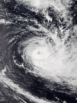
Severe Tropical Cyclone Ula was a powerful and long-lived tropical cyclone during late December 2015 and mid-January 2016. It originated from a tropical disturbance on December 26, 2015, east of the Solomon Islands. Moving generally east, development was initially slow and the system finally reached cyclone strength—having gale-force winds—on December 30. The newly christened Tropical Cyclone Ula turned sharply south and rapidly intensified, attaining hurricane strength the following day. A shift to the southwest brought the system close to the northern islands of Tonga on January 2, 2016. It subsequently brushed several islands in the Lau Group of Fiji before weakening. Nearly degrading to a tropical depression, Ula turned to the northwest and regained strength. After turning back to the southwest, it achieved its peak intensity as a Category 4 on the Australian scale with winds of 185 km/h (115 mph) on January 10. Thereafter, the storm bypassed Vanuatu to the southeast and New Caledonia to the east as it accelerated southward.
Tonga was the first South Pacific country to put a conservation programme in place with a series of national marine reserves. The country has four national parks which are administered by Forest Division, which falls under the Ministry of Environment and Climate Change.
Tropical Cyclone Sarai was a moderately strong tropical cyclone that impacted several island nations and countries in late-December 2019. The third tropical cyclone and the second named storm of the 2019-20 South Pacific cyclone season, Sarai formed from an area of low pressure to the south of Tuvalu. Over the next days, the low pressure became organized and was designated by the Fiji Meteorological Service as Tropical Disturbance 03F on December 23. Under favorable conditions, the disturbance gradually organized, becoming a depression two days later, before strengthening to a tropical cyclone, earning the name Sarai. It moved to the south, before a high-pressure steered the system to the east, passing to the south of Fiji, near Suva before weakening. Sarai passed near the Tongan islands of Haʻapai and Tongatapu as a Category 1 cyclone, before rapidly degrading to a tropical depression due to the system entering unfavorable conditions. It was last noted on January 2 to the southeast of Cook Islands.
References
- ↑ "Sisia: Tonga". Geographical Names. Retrieved 30 January 2021.
18°44′S174°03′W / 18.733°S 174.050°W
| | This Tongan location article is a stub. You can help Wikipedia by expanding it. |