The Hartley Colliery disaster was a coal mining accident in Northumberland, England, that occurred on 16 January 1862 and resulted in the deaths of 204 men and children. The beam of the pit's pumping engine broke and fell down the shaft, trapping the men below. The disaster prompted a change in British law that required all collieries to have at least two independent means of escape.

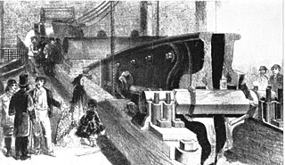
Wet Earth Colliery was a coal mine located on the Manchester Coalfield, in Clifton, Greater Manchester. The colliery site is now the location of Clifton Country Park. The colliery has a unique place in British coal mining history; apart from being one of the earliest pits in the country, it is the place where engineer James Brindley made water run uphill.

The Anson Engine Museum is situated on the site of the old Anson colliery in Poynton, Cheshire, England. It is the work of Les Cawley and Geoff Challinor who began collecting and showing stationary engines for a hobby. The museum now has one of the largest collections of engines in Europe. The museum site also includes a working blacksmith's smithy and carpentry shop and a café.
Parkfield Colliery, near Pucklechurch, South Gloucestershire, was sunk in 1851 under the ownership of Handel Cossham. Coal was reached in 1853. The shaft was 840 ft deep, but only the upper series of coal veins were worked. These were the Hard, the Top, the Hollybush and Great veins. The quality of the coal mined was extremely good, and was used for gas manufacture and house coal.

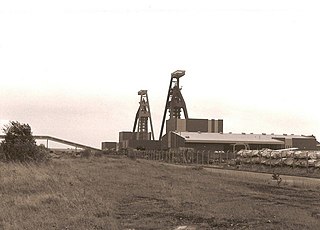
Pleasley Colliery is a former English coal mine. It is located to the north-west of Pleasley village, which sits above the north bank of the River Meden on the Nottinghamshire/Derbyshire border. It lies 3 miles (4.8 km) north of Mansfield and 9 miles (14.5 km) south of Chesterfield. From the south it commands a prominent position on the skyline, although less so now than when the winders were in operation and both chimney stacks were in place. The colliery is situated at about 500 ft (152m) above sea level and is aligned on a NE–SW axis following the trend of the river valley at this point.

The Ingleton Coalfield is in North Yorkshire, close to its border with Lancashire in north-west England. Isolated from other coal-producing areas, it is one of the smallest coalfields in Great Britain.

Astley Green Colliery was a coal mine in Astley, Greater Manchester, then in the historic county of Lancashire, England. It was the last colliery to be sunk in Astley. Sinking commenced in 1908 by the Pilkington Colliery Company, a subsidiary of the Clifton and Kersley Coal Company, at the southern edge of the Manchester Coalfield, working the Middle Coal Measures where they dipped under the Permian age rocks under Chat Moss. The colliery was north of the Bridgewater Canal. In 1929 it became part of Manchester Collieries, and in 1947 was nationalised and integrated into the National Coal Board. It closed in 1970, and is now Astley Green Colliery Museum.
Pendleton Colliery was a coal mine operating on the Manchester Coalfield after the late 1820s on Whit Lane in Pendleton, Salford, then in the historic county of Lancashire, England.

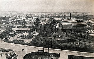
Bradford Colliery was a coal mine in Bradford, Manchester, England. Although part of the Manchester Coalfield, the seams of the Bradford Coalfield correspond more closely to those of the Oldham Coalfield. The Bradford Coalfield is crossed by a number of fault lines, principally the Bradford Fault, which was reactivated by mining activity in the mid-1960s.

Deep Navigation Colliery was a coal mine in South Wales, that operated from 1872 until 1991.

Great Western Mine, also known as Hetty Pit, was a coal mine, at Hopkinstown, near Pontypridd, Glamorgan in South Wales.

The Avon and Gloucestershire Railway also known as The Dramway was an early mineral railway, built to bring coal from pits in the Coalpit Heath area, north-east of Bristol, to the River Avon opposite Keynsham. It was dependent on another line for access to the majority of the pits, and after early success, bad relations and falling traffic potential dogged most of its existence.

The Racecourse Colliery is an exhibit located at the Black Country Living Museum.
Thorne Colliery was a large colliery within the Metropolitan Borough of Doncaster, South Yorkshire in the South Yorkshire Coalfield.
This is a partial glossary of coal mining terminology commonly used in the coalfields of the United Kingdom. Some words were in use throughout the coalfields, some are historic and some are local to the different British coalfields.

Calvert's Engine or the Newbridge Colliery Engine is a beam engine of 1845, now preserved on the campus of the University of Glamorgan, South Wales.

The Burnley Coalfield is the most northerly portion of the Lancashire Coalfield. Surrounding Burnley, Nelson, Blackburn and Accrington, it is separated from the larger southern part by an area of Millstone Grit that forms the Rossendale anticline. Occupying a syncline, it stretches from Blackburn past Colne to the Yorkshire border where its eastern flank is the Pennine anticline.

Bank Hall Colliery was a coal mine on the Burnley Coalfield in Burnley, Lancashire near the Leeds and Liverpool Canal. Sunk in the late 1860s, it was the town's largest and deepest pit and had a life of more than 100 years.
Hapton Valley Colliery was a coal mine on the edge of Hapton near Burnley in Lancashire, England. Its first shafts were sunk in the early 1850s and it had a life of almost 130 years, surviving to be the last deep mine operating on the Burnley Coalfield.
Ellesmere Colliery was a coal mine in Walkden, Manchester, England. The pit was located on Manchester Road, a short distance south of Walkden town centre.
