
Chhattisgarh is a landlocked state in Central India. It is the ninth largest state by area, and with a population of roughly 30 million, the seventeenth most populous. It borders seven states – Uttar Pradesh to the north, Madhya Pradesh to the northwest, Maharashtra to the southwest, Jharkhand to the northeast, Odisha to the east, Andhra Pradesh and Telangana to the south. Formerly a part of Madhya Pradesh, it was granted statehood on 1 November 2000 with Raipur as the designated state capital.

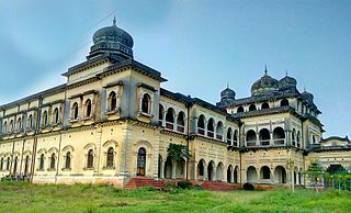
Ambikapur is a city and headquarters of Surguja district in the Indian state of Chhattisgarh. It is one of the oldest cities in the state, in east-central India. Ambikapur is also the divisional headquarters of Surguja Division which consists of the six districts of Surguja, Korea, Manendragarh, Balrampur, Surajpur and Jashpur.
Garhwa is a town and a municipality in, and headquarters of, Garhwa district in the state of Jharkhand, India. Uttar Pradesh, Chhattisgarh and Bihar are nearby states. Garhwa Road (Rehla) is a major Railway Junction where thousands of passengers find this station most convenient to catch their train for Delhi and Kolkata. Bus services are available for Ranchi, Ambikapur, Gaya, etc.

The Rihand River is a tributary of the Son River and flows through the Indian states of Chhattisgarh, Madhya Pradesh and Uttar Pradesh. Its old name was Renu or Renuka.

Korea State, currently spelt as Koriya, was a small princely state inthe British Empire of India. After Indian independence in 1947, the ruler of Korea acceded to the Union of India on 1 January 1948, and Koriya was made part of Surguja District of Central Provinces and Berar province. In January 1950, "Central Provinces and Berar" province was renamed Madhya Pradesh state. After November 2000, Korea and the former princely state of Changbhakar became Koriya district of Chhattisgarh state.
Koriya district, officially known as Korea district, is a district in the north-western part of the Chhattisgarh state in Central India. The administrative headquarters of the district is Baikunthpur.
Surguja district is a district of the Indian state of Chhattisgarh. The district is one of the oldest districts of Chhattisgarh. The headquarters of the district is Ambikapur.
Bhaiyathan is a panchayat village in Surajpur District in the Indian state of Chhattisgarh. Bhaiyathan is part of a community development block under the jurisdiction of Surajpur district and is 23 km away from Supurown. It is situated on the bank of the Rihand River. Tamor Pingla Wildlife Sanctuary is a major attraction nearby. A famous Devi temple on a hill, Kudargarh, is just 23 km from Bhaiyathan.
The Mand River is a tributary of the Mahanadi in India. It joins the Mahanadi in Chandarpur, in Chhattisgarh, 28 km from the Odisha border and before the river reaches the Hirakud Dam.
Korwa, or Kodaku/Koraku (Korku), is a Munda language of India spoken in Chhattisgarh and Jharkhand.

Surajpur district is a district in the state of Chhattisgarh in central India, with its administrative headquarters at Surajpur. National Highway 43 passes through Surajpur district. Surajpur was declared a district on 15 August 2011 along with eight other new districts. Surajpur is the first district to receive National Satyan Maitra Literacy Award. The district is known for its market and other major tourist places of Chhattisgarh with Tamor Pingla Wildlife Sanctuary.

Balrampur-Ramanujganj district is a district in the Indian state of Chhattisgarh. It came into existence on 17 January 2012 and was formerly part of Surguja district. Balrampur-Ramanujganj district is the northernmost district of Chhattisgarh. Its seat is Balrampur.
Mainpat is a hill station and small village in the Surguja district in the northern part of the state of Chhattisgarh, India. It lies about 55 kilometres (34 mi) by road from the divisional headquarter of Ambikapur. The hill station is 50 km south of Ambikapur, 160 km northeast of Korba, and 360 km northeast of state capital Raipur.

Udaipur State was one of the princely states of India during the period of the British Raj. The town of Dharamjaigarh was the former state's capital.
Ramchandrapur is an administrative block/Tehsil/Taluka of Balrampur district, in the Indian state of Chhattisgarh.

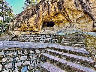
Tourism is an important part of the economy of the Indian state of Chhattisgarh, India's tenth largest state. The state has many ancient monuments, rare wildlife, carved temples, Buddhist sites, palaces, water falls, caves, rock paintings and hill plateaus.
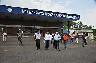
Maa Mahamaya Ambikapur Airport or Ambikapur Airport is located at Darima, 12 km (7.5 mi) south of Ambikapur, in Chhattisgarh, India. The airport serves Ambikapur, one of the major city of Chhattisgarh state. It also serves the nearby towns of Surajpur, Baikunthpur, Bhatgaon, Mainpat, Sitapur, Brishrampur, Balrampur, Ramanujganj, etc. therefore this airport provides air connectivity to entire Northern Chhattisgarh.
Sitapur is one of the 90 Legislative Assembly constituencies of Chhattisgarh state in India. It is in Surguja district and is reserved for candidates belonging to the Scheduled Tribes.
