Related Research Articles

Civil engineering is a professional engineering discipline that deals with the design, construction, and maintenance of the physical and naturally built environment, including public works such as roads, bridges, canals, dams, airports, sewage systems, pipelines, structural components of buildings, and railways.

Geotechnical engineering, also known as geotechnics, is the branch of civil engineering concerned with the engineering behavior of earth materials. It uses the principles of soil mechanics and rock mechanics to solve its engineering problems. It also relies on knowledge of geology, hydrology, geophysics, and other related sciences.
Petroleum engineering is a field of engineering concerned with the activities related to the production of hydrocarbons, which can be either crude oil or natural gas. Exploration and production are deemed to fall within the upstream sector of the oil and gas industry. Exploration, by earth scientists, and petroleum engineering are the oil and gas industry's two main subsurface disciplines, which focus on maximizing economic recovery of hydrocarbons from subsurface reservoirs. Petroleum geology and geophysics focus on provision of a static description of the hydrocarbon reservoir rock, while petroleum engineering focuses on estimation of the recoverable volume of this resource using a detailed understanding of the physical behavior of oil, water and gas within porous rock at very high pressure.
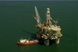
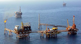
An oil platform is a large structure with facilities to extract and process petroleum and natural gas that lie in rock formations beneath the seabed. Many oil platforms will also have facilities to accommodate the workers, although it is also common to have a separate accommodation platform linked by bridge to the production platform. Most commonly, oil platforms engage in activities on the continental shelf, though they can also be used in lakes, inshore waters, and inland seas. Depending on the circumstances, the platform may be fixed to the ocean floor, consist of an artificial island, or float. In some arrangements the main facility may have storage facilities for the processed oil. Remote subsea wells may also be connected to a platform by flow lines and by umbilical connections. These sub-sea facilities may include one or more subsea wells or manifold centres for multiple wells.

An oil well is a drillhole boring in Earth that is designed to bring petroleum oil hydrocarbons to the surface. Usually some natural gas is released as associated petroleum gas along with the oil. A well that is designed to produce only gas may be termed a gas well. Wells are created by drilling down into an oil or gas reserve and if necessary equipped with extraction devices such as pumpjacks. Creating the wells can be an expensive process, costing at least hundreds of thousands of dollars, and costing much more when in difficult-to-access locations, e.g., offshore. The process of modern drilling for wells first started in the 19th century but was made more efficient with advances to oil drilling rigs and technology during the 20th century.
Construction is a general term meaning the art and science of forming objects, systems, or organizations. It comes from the Latin word constructio and Old French construction. To 'construct' is a verb: the act of building, and the noun is construction: how something is built or the nature of its structure.

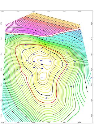
Hydrocarbon exploration is the search by petroleum geologists and geophysicists for deposits of hydrocarbons, particularly petroleum and natural gas, in the Earth's crust using petroleum geology.

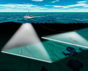
Reflection seismology is a method of exploration geophysics that uses the principles of seismology to estimate the properties of the Earth's subsurface from reflected seismic waves. The method requires a controlled seismic source of energy, such as dynamite or Tovex blast, a specialized air gun or a seismic vibrator. Reflection seismology is similar to sonar and echolocation.

A floating production storage and offloading (FPSO) unit is a floating vessel used by the offshore oil and gas industry for the production and processing of hydrocarbons, and for the storage of oil. An FPSO vessel is designed to receive hydrocarbons produced by itself or from nearby platforms or subsea template, process them, and store oil until it can be offloaded onto a tanker or, less frequently, transported through a pipeline. FPSOs are preferred in frontier offshore regions as they are easy to install, and do not require a local pipeline infrastructure to export oil. FPSOs can be a conversion of an oil tanker or can be a vessel built specially for the application. A vessel used only to store oil is referred to as a floating storage and offloading (FSO) vessel.
Exploration geophysics is an applied branch of geophysics and economic geology, which uses physical methods at the surface of the Earth, such as seismic, gravitational, magnetic, electrical and electromagnetic, to measure the physical properties of the subsurface, along with the anomalies in those properties. It is most often used to detect or infer the presence and position of economically useful geological deposits, such as ore minerals; fossil fuels and other hydrocarbons; geothermal reservoirs; and groundwater reservoirs. It can also be used to detect the presence of unexploded ordnance.
A petroleum reservoir or oil and gas reservoir is a subsurface accumulation of hydrocarbons contained in porous or fractured rock formations. Such reservoirs form when kerogen is created in surrounding rock by the presence of high heat and pressure in the Earth's crust.

Magnetotellurics (MT) is an electromagnetic geophysical method for inferring the earth's subsurface electrical conductivity from measurements of natural geomagnetic and geoelectric field variation at the Earth's surface.

Cultural heritage management (CHM) is the vocation and practice of managing cultural heritage. It is a branch of cultural resources management (CRM), although it also draws on the practices of cultural conservation, restoration, museology, archaeology, history and architecture. While the term cultural heritage is generally used in Europe, in the US the term cultural resources is in more general use specifically referring to cultural heritage resources.

Drill cuttings are broken bits of solid material removed from a borehole drilled by rotary, percussion, or auger methods and brought to the surface in the drilling mud. Boreholes drilled in this way include oil or gas wells, water wells, and holes drilled for geotechnical investigations or mineral exploration.
Petrophysics is the study of physical and chemical rock properties and their interactions with fluids.

Construction waste or debris is any kind of debris from the construction process. Different government agencies have clear definitions. For example, the United States Environmental Protection Agency EPA defines construction and demolition materials as “debris generated during the construction, renovation and demolition of buildings, roads, and bridges.” Additionally, the EPA has categorized Construction and Demolition (C&D) waste into three categories: non-dangerous, hazardous, and semi-hazardous.
Subsea technology involves fully submerged ocean equipment, operations, or applications, especially when some distance offshore, in deep ocean waters, or on the seabed. The term subsea is frequently used in connection with oceanography, marine or ocean engineering, ocean exploration, remotely operated vehicle (ROVs) autonomous underwater vehicles (AUVs), submarine communications or power cables, seafloor mineral mining, oil and gas, and offshore wind power.
Offshore geotechnical engineering is a sub-field of geotechnical engineering. It is concerned with foundation design, construction, maintenance and decommissioning for human-made structures in the sea. Oil platforms, artificial islands and submarine pipelines are examples of such structures. The seabed has to be able to withstand the weight of these structures and the applied loads. Geohazards must also be taken into account. The need for offshore developments stems from a gradual depletion of hydrocarbon reserves onshore or near the coastlines, as new fields are being developed at greater distances offshore and in deeper water, with a corresponding adaptation of the offshore site investigations. Today, there are more than 7,000 offshore platforms operating at a water depth up to and exceeding 2000 m. A typical field development extends over tens of square kilometers, and may comprise several fixed structures, infield flowlines with an export pipeline either to the shoreline or connected to a regional trunkline.
In the petroleum industry, allocation refers to practices of breaking down measures of quantities of extracted hydrocarbons across various contributing sources. Allocation aids the attribution of ownerships of hydrocarbons as each contributing element to a commingled flow or to a storage of petroleum may have a unique ownership. Contributing sources in this context are typically producing petroleum wells delivering flows of petroleum or flows of natural gas to a commingled flow or storage.
An underwater survey is a survey performed in an underwater environment or conducted remotely on an underwater object or region. Survey can have several meanings. The word originates in Medieval Latin with meanings of looking over and detailed study of a subject. One meaning is the accurate measurement of a geographical region, usually with the intention of plotting the positions of features as a scale map of the region. This meaning is often used in scientific contexts, and also in civil engineering and mineral extraction. Another meaning, often used in a civil, structural, or marine engineering context, is the inspection of a structure or vessel to compare actual condition with the specified nominal condition, usually with the purpose of reporting on the actual condition and compliance with, or deviations from, the nominal condition, for quality control, damage assessment, valuation, insurance, maintenance, and similar purposes. In other contexts it can mean inspection of a region to establish presence and distribution of specified content, such as living organisms, either to establish a baseline, or to compare with a baseline.
References
- ↑ Ramirez, Ricardo R.; et al. (2004). "Benchmarking System for Evaluating Management Practices in the Construction Industry". Journal of Management in Engineering. 20 (3): 110–117. doi:10.1061/(ASCE)0742-597X(2004)20:3(110).
- ↑ Weich, Scott; Burton, Elizabeth; Blanchard, Martin; Prince, Martin; Sproston, Kerry; Erens, Bob (2001). "Measuring the built environment: validity of a site survey instrument for use in urban settings". Health & Place. 7 (4): 283–292. doi:10.1016/S1353-8292(01)00019-3. PMID 11682328.
- ↑ Walker, Merle F. (1970). "The California Site Survey". Publications of the Astronomical Society of the Pacific. 82 (487): 672–698. Bibcode:1970PASP...82..672W. doi:10.1086/128945. JSTOR 40674892. S2CID 121966072.
- ↑ Zvanovec, S.; Pechac, P.; Klepal, M. (2003). "Wireless LAN Network Design: Site Survey or Propagation Modeling?". Radioengineering. 12 (4): 42. CiteSeerX 10.1.1.525.198 .
- ↑ Abrams, M.A.; Segall, M.P.; Burtell, S.G. (2001). "Best Practices for Detecting, Identifying and Characterizing Near-Surface Migration of Hydrocarbons within Marine Sediments". Offshore Technology Conference. doi:10.4043/13039-MS. ISBN 978-1-55563-248-9.