Related Research Articles

Hudiksvall Municipality is one of Sweden's 290 municipalities, situated in Gävleborg County, east central Sweden. Its seat is in the city Hudiksvall.

Fenno–Skan is the designation of the high voltage direct current transmission between Dannebo in Sweden and Rauma in Finland.
Burges James Gadsden Provincial Park is a provincial park in British Columbia, Canada, south of the confluence of the Blaeberry and Columbia Rivers, northwest of Golden.

This is a list of the extreme points of the Philippines, the points that are farther north, south, east or west than any other location in the country.
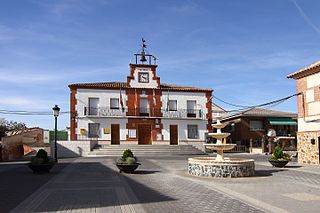
Arcicóllar is a municipality located in the province of Toledo, Castile-La Mancha, Spain. According to the 2006 census (INE), the municipality has a population of 720 inhabitants.
Gò Dầu is a rural district in the south of Tây Ninh Province, Southeast region, Vietnam. In 2003, the district had a population of 140,661. The district covers an area of 251 km². The district capital is Gò Dầu Town.

Stary Besk is a village in the administrative district of Gmina Grabów, within Łęczyca County, Łódź Voivodeship, in central Poland. It lies approximately 13 kilometres (8 mi) north-west of Łęczyca and 47 km (29 mi) north-west of the regional capital Łódź.

Kolqışlaq is a village in the Agdam Rayon of Azerbaijan. The village forms part of the municipality of Qərvənd.
Derekyshlak is a village in the Kalbajar Rayon of Azerbaijan.
The Findlay Group is a group of islands in the Canadian Arctic Archipelago in Qikiqtaaluk Region, Nunavut. This Arctic Ocean group consists of Lougheed Island, Stupart Island, Edmund Walker Island, Grosvenor Island and Patterson Island.
Bożatki is a village in the administrative district of Gmina Rzgów, within Konin County, Greater Poland Voivodeship, in west-central Poland. It lies approximately 19 kilometres (12 mi) south-west of Konin and 84 km (52 mi) east of the regional capital Poznań.
Dobczyn is a village in the administrative district of Gmina Śrem, within Śrem County, Greater Poland Voivodeship, in west-central Poland. It lies approximately 8 kilometres (5 mi) south-east of Śrem and 42 km (26 mi) south of the regional capital Poznań.
Suurmetsä (Finnish), Storskog (Swedish) is a subdistrict of Helsinki, Finland.
Kudani is a village in Lääne-Nigula Parish, Lääne County, in western Estonia.
Sutlepa is a village in Lääne-Nigula Parish, Lääne County, in western Estonia.
Väike-Nõmmküla is a village in Lääne-Nigula Parish, Lääne County, in western Estonia.
Al Munirah District is a district of the Al Hudaydah Governorate, Yemen. As of 2003, the district had a population of 37,183 inhabitants.

This is a list of the extreme points of Bhutan.
Kuz Paro is an administrative unit, known as Union council of Kohistan District in the Khyber Pakhtunkhwa province of Pakistan.
References
- ↑ "Län och huvudavrinningsområden i Sverige" (PDF) (in Swedish). Swedish Meteorological and Hydrological Institute . Retrieved 15 July 2010.
Coordinates: 61°03′N17°07′E / 61.050°N 17.117°E

A geographic coordinate system is a coordinate system that enables every location on Earth to be specified by a set of numbers, letters or symbols. The coordinates are often chosen such that one of the numbers represents a vertical position and two or three of the numbers represent a horizontal position; alternatively, a geographic position may be expressed in a combined three-dimensional Cartesian vector. A common choice of coordinates is latitude, longitude and elevation. To specify a location on a plane requires a map projection.
| This article related to a river in Sweden is a stub. You can help Wikipedia by expanding it. |