
Nicosia, also known as Lefkosia in Greek and Lefkoşa in Turkish, is the capital and largest city of Cyprus.

Famagusta, also known by several other names, is a city on the east coast of the de facto state Northern Cyprus. It is located east of Nicosia and possesses the deepest harbour of the island. During the Middle Ages, Famagusta was the island's most important port city and a gateway to trade with the ports of the Levant, from where the Silk Road merchants carried their goods to Western Europe. The old walled city and parts of the modern city are de facto part of Northern Cyprus as the capital of the Gazimağusa District.
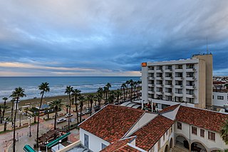
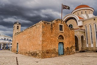
Larnaca is a city on the south east coast of Cyprus and the capital of the district of the same name. It is the third-largest city in the country, after Nicosia and Limassol, with a district population of 144,200 in 2015.
The Eyalet of Cyprus was an eyalet (province) of the Ottoman Empire made up of the island of Cyprus, which was annexed into the Empire in 1571. The Ottomans changed the way they administered Cyprus multiple times. It was a sanjak (sub-province) of the Eyalet of the Archipelago from 1670 to 1703, and again from 1784 onwards; a fief of the Grand Vizier ; and again an eyalet for the short period from 1745 to 1748.

Larnaca International Airport – Glafcos Clerides is an international airport located 4 km (2.5 mi) southwest of Larnaca, Cyprus. Larnaca International Airport is Cyprus' main international gateway and the larger of the two commercial airports in the area controlled by the Republic of Cyprus, the other being Paphos International Airport on the island's southwestern coast. The airport was given its current name in July 2016, in honour of former President of Cyprus Glafcos Clerides.

Hala Sultan Tekke is a mosque and takya on the west bank of Larnaca Salt Lake, in Larnaca, Cyprus. Umm Haram, known as Hala Sultan in Turkish tradition, was the wife of Ubada bin al-Samit, a companion of the Islamic prophet Muhammad, and foster sister of Muhammad's mother, Amina.
Islam in Cyprus is the island's second-largest religion after Christianity, and is also the predominant faith of the Turkish Cypriot community which resides in Northern Cyprus. Before the Turkish invasion of Cyprus in 1974, the Turkish Cypriot community made up 18% of the island's population and lived throughout the island. Today, most of the estimated 264,172 Muslims are based in the north of the island.
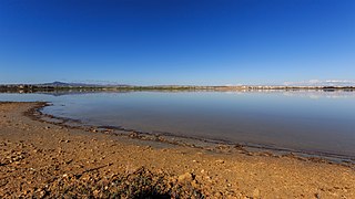
Larnaca Salt Lake is a complex network of four salt lakes of different sizes to the west of the city of Larnaca. The largest is lake Aliki, followed by lake Orphani, lake Soros and lake Spiro. They form the second largest salt lake in Cyprus after the Limassol Salt Lake. The total surface area of the lakes adds up to 2.2 km2 and being just off the road leading to Larnaca International Airport, the lake is one of the most distinctive landmarks of the area. It is considered one of the most important wetlands of Cyprus and it has been declared a Ramsar site, Natura 2000 site, Special Protected Area under the Barcelona Convention and an Important Bird Area (IBA). It is surrounded by halophytic scrubland and on its bank lies the Hala Sultan Tekke, one of the holiest of shrines within Ottoman Islam. It houses the tomb of Umm Haram, Muhammad's 'wet-nurse'.

Lala Mustafa Pasha, also known by the additional epithet Kara, was an Ottoman Bosnian general and Grand Vizier from the Sanjak of Bosnia.
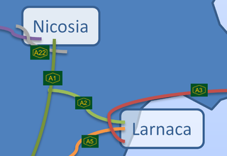
The A2 motorway in Cyprus is a road which branches off the A1 at Pera Chorio-Nisou and connects to the A3. It is referred to locally as the Nicosia - Larnaca motorway. It is also called "the tube" because it is mostly straight with a very limited number of exits. Two of its 6 junctions are limited access to facilitate access to Athienou.

Trikomo is a town in North-Eastern Mesaoria in Cyprus. It is under the de facto control of Northern Cyprus and is the administrative center of the İskele District of Northern Cyprus. It gained municipality status in 1998.
Xylofagou is a sprawling Greek-Cypriot village situated close to the A3 Motorway between Dhekelia (Larnaca) and Paralimni / Agia Napa. It lies on the northern flank of a hill, on the edge of an area of a group of several similar villages known as the "Kokkinochoria", known for growing vegetables, especially potatoes, in red soil.
Religion in Cyprus is dominated by Eastern Orthodox branch of Christianity, whose adherents make up 73% of the total population of the entire island. Most Greek Cypriots are members of the autocephalous Greek Orthodox 'Church of Cyprus'. Most Turkish Cypriots are officially Sunni Muslims. There are also Baháʼí, Catholic, Jewish, Protestant, Armenian Apostolic, and non-religious communities in Cyprus.
Anafotia is a village located in the Larnaca District of Cyprus, west of Larnaca. In 1994, the official name of the village became Anafotida (Aναφωτίδα), following a decision by the then-government of Cyprus to make the names of villages on the island more Greek. However, locally the village is still referred to as Anafotia.
Kalo Chorio Larnakas is a village located in the Larnaca District of Cyprus, 10 km west of the town of Larnaca. Prior to 1974, the majority of the village consisted of Turkish Cypriots.
Ebubekir Pasha, also referred to as Koca Bekir Pasha and Abu Bakr Pasha or Abubakr Pasha, was an Ottoman statesman. He served as Kapudan Pasha ; as governor (beylerbey) of the provinces of Egypt, Jeddah, Cyprus, and Bosnia; and as head of the Imperial Mint. He was the fourth and last husband of Safiye Sultan and thus son-in-law (damat) of Sultan Mustafa II.
This article documents the status of various religions in the limited-recognition state of Northern Cyprus. Turkish Cypriots administer approximately one-third of the island.

Larnaca Castle is a castle located on the southern coast of Cyprus. It was constructed to defend the southern coast of Cyprus and the harbour town of Larnaca and was later used as an artillery station, prison, and a museum.
The Domari-speaking community in Syria, commonly identified as Dom and Nawar, is estimated to number 100–250,000 or 250–300,000 people. The vast majority is sedentary. There are semi-nomadic groups, some moving outside the country. In Aleppo, the Dom community is probably the largest, while they are reported to live in Damascus, Homs and Latakia as well. The community is highly marginalised in society, and they are referred to as Qurbāṭ and Qarač in the northern part, and Nawar elsewhere. These terms are used for various groups that mainly share socio-economic profile. The community is divided into clans.