Tysfjord (Norwegian) or Divtasvuodna (Lule Sami) is a former municipality in Nordland county, Norway. The municipality existed from 1869 until its dissolution in 2020. The municipality was part of the traditional district of Ofoten. The administrative centre of the municipality was the village of Kjøpsvik. Other villages included Drag, Hundholmen, Korsnes, Musken, Rørvika, Skarberget, and Storå.
Lødingen is a municipality in Nordland county in Norway. Lødingen is located on the southeastern corner of the island of Hinnøya, and is part of the traditional district of Ofoten. The administrative centre of the municipality is the village of Lødingen. The other main village is Vestbygda. Lødingen has the nickname "Biketown" because it hosts several annual bicycle races like Lofoten Insomnia and Vestbygd-rittet.

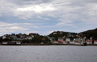
Kjøpsvik (Norwegian) or Gásluokta (Northern Sami) is a village in Narvik Municipality in Nordland county, Norway. The village is located on the eastern shore of the Tysfjorden, north of the small village of Storå. The island of Hulløya lies off the coast of Kjøpsvik. The 1.01-square-kilometre (250-acre) village has a population (2018) of 845 which gives the village a population density of 837 inhabitants per square kilometre (2,170/sq mi).

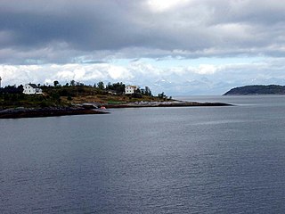
Drag (Norwegian) or Ájluokta (Lule Sami) or Áiluokta (Northern Sami) is a village in the municipality of Hamarøy in Nordland county, Norway. It is located along the Tysfjorden, about 180 kilometres (110 mi) northeast of the town of Bodø and about 110 kilometres (68 mi) south of the town of Narvik. The 0.44-square-kilometre (110-acre) village has a population (2018) of 319 which gives the village a population density of 725 inhabitants per square kilometre (1,880/sq mi).
The Polar Line is an incomplete and abandoned railway line from Fauske, Norway, to Narvik and, if finished, ultimately would have run 1,215 km (755 mi) to Kirkenes.

Partido de la Sierra en Tobalina is a municipality located in the province of Burgos, Castile and León, Spain. According to the 2004 census (INE), the municipality has a population of 68 inhabitants. Its seat is in Valderrama.

Pieszków is a village in the administrative district of Gmina Lubin, within Lubin County, Lower Silesian Voivodeship, in south-western Poland. Prior to 1945 it was in Germany. It lies approximately 8 kilometres (5 mi) south of Lubin and 61 km (38 mi) west of the regional capital Wrocław.
Kawkareik Township is a township of Kawkareik District in the Karen State of Myanmar. The principal town is Kawkareik. Kawkareik township is the second most populated township in Karen State and there are many small villages inside.
Bhamo Township is a township of Bhamo District in the Kachin State of Burma. The principal town is Bhamo.
Zagaty is a village in the administrative district of Gmina Chorzele, within Przasnysz County, Masovian Voivodeship, in east-central Poland. It lies approximately 5 kilometres (3 mi) south-east of Chorzele, 25 km (16 mi) north of Przasnysz, and 113 km (70 mi) north of Warsaw.
Antoniów is a village in the administrative district of Gmina Skaryszew, within Radom County, Masovian Voivodeship, in east-central Poland. It lies approximately 5 kilometres (3 mi) south of Skaryszew, 16 km (10 mi) south of Radom, and 107 km (66 mi) south of Warsaw.
Polany is a village in the administrative district of Gmina Wierzbica, within Radom County, Masovian Voivodeship, in east-central Poland. It lies approximately 4 kilometres (2 mi) south-east of Wierzbica, 19 km (12 mi) south of Radom, and 110 km (68 mi) south of Warsaw.

Pomorzany is a village in the administrative district of Gmina Wierzbica, within Radom County, Masovian Voivodeship, in east-central Poland. It lies approximately 6 kilometres (4 mi) east of Wierzbica, 19 km (12 mi) south of Radom, and 110 km (68 mi) south of Warsaw.

Cierpigórz is a village in the administrative district of Gmina Przesmyki, within Siedlce County, Masovian Voivodeship, in east-central Poland. It lies approximately 4 kilometres (2 mi) south of Przesmyki, 24 km (15 mi) east of Siedlce, and 110 km (68 mi) east of Warsaw.
Gąsawy Plebańskie is a village in the administrative district of Gmina Jastrząb, within Szydłowiec County, Masovian Voivodeship, in east-central Poland. It lies approximately 2 kilometres (1 mi) south of Jastrząb, 7 km (4 mi) east of Szydłowiec, and 110 km (68 mi) south of Warsaw.
Śmiłów is a village in the administrative district of Gmina Jastrząb, within Szydłowiec County, Masovian Voivodeship, in east-central Poland. It lies approximately 3 kilometres (2 mi) south-west of Jastrząb, 5 km (3 mi) east of Szydłowiec, and 110 km (68 mi) south of Warsaw.
Mirówek is a village in the administrative district of Gmina Mirów, within Szydłowiec County, Masovian Voivodeship, in east-central Poland. It lies approximately 4 kilometres (2 mi) north of Mirów, 13 km (8 mi) east of Szydłowiec, and 110 km (68 mi) south of Warsaw.
Kamień is a village in the administrative district of Gmina Ceków-Kolonia, within Kalisz County, Greater Poland Voivodeship, in west-central Poland. It lies approximately 8 kilometres (5 mi) south-west of Ceków-Kolonia, 14 km (9 mi) north-east of Kalisz, and 110 km (68 mi) south-east of the regional capital Poznań.

Bognes is a ferry port in Hamarøy Municipality in Nordland county, Norway. It is located in the outer part of the Tysfjorden on the western side of the fjord. The port is located about 5 kilometres (3.1 mi) south of the village of Korsnes and about 15 kilometres (9.3 mi) north of the village of Rørvika.

Tysfjorden (Norwegian) or Divtasvuodna (Lule Sami) or Tys Fjord (English) is a fjord in Nordland county, Norway. The fjord is the border between Narvik Municipality and Hamarøy Municipality. The island of Hulløya is located about halfway through the fjord, right before the fjord splits in to several smaller branches. The Tysfjorden is the deepest fjord in Northern Norway reaching to 897 metres (2,943 ft) below sea level near Hulløya.
