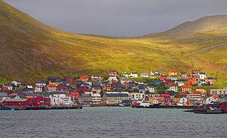
Nordkapp is a municipality in Finnmark county, Norway. The administrative centre of the municipality is the town of Honningsvåg, where most residents live. Other settlements in Nordkapp include the villages of Gjesvær, Kåfjord, Kamøyvær, Kjelvik, Nordvågen, Repvåg, Skarsvåg, and Valan.

North Cape is a cape on the northern coast of the island of Magerøya in Northern Norway. The cape is in Nordkapp Municipality in Finnmark county, Norway. The European route E69 motorway (highway) has its northern terminus at North Cape, which makes it the northernmost point in Europe that can be accessed by car and makes the E69 the northernmost public road in Europe. The plateau is a popular tourist attraction. The cape includes a 307-metre-high cliff (1,007 ft) with a large flat plateau on top, where visitors, weather permitting, can watch the midnight sun and views of the Barents Sea to the north. North Cape Hall, a visitor centre, was built in 1988 on the plateau. It includes a café, restaurant, post office, souvenir shop, a small museum, and video cinema.

Magerøya is a large island in Troms og Finnmark county, in the extreme northern part of Norway. The island lies along the Barents Sea in Nordkapp Municipality, just north of the Porsanger Peninsula. The mouth of Porsangerfjorden lies off the east coast of the island.
North Cape, Northern Cape, or Nordkapp may refer to:

Knivskjellodden or Knivskjelodden is a peninsula located in Nordkapp Municipality in Finnmark county, Norway. It is the northernmost point on the island of Magerøya in Northern Norway. It is sometimes considered the northernmost point of the entire continent of Europe. The nearby Kinnarodden on the Nordkinn Peninsula is the northernmost point on the mainland. The northernmost point of the country Norway is in fact Rossøya, in Svalbard, as far north as 80°N.

is the northernmost city in mainland Norway. It is located in Nordkapp Municipality in Finnmark county. Honningsvåg was declared a city in 1996, despite its small population. The 1.05-square-kilometre (260-acre) town has a population of 2,484 (2017) which gives the town a population density of 2,366 inhabitants per square kilometre (6,130/sq mi).

North Cape Tunnel is one of the longest and the northernmost of the subsea road tunnels in Norway. It is located in Nordkapp Municipality in Finnmark county in the far northern part of Norway. The tunnel takes the European route E69 highway under the Magerøysundet strait between the Norwegian mainland and the large island of Magerøya. The tunnel was built between 1993 and 1999, along with the Honningsvåg Tunnel. The tunnels were built to connect the mainland of Norway with the town of Honningsvåg and the tourist attraction at the North Cape. The tunnel was officially opened on 15 June 1999 by King Harald V of Norway. The tunnel is 6.875 kilometres (4.272 mi) long and reaches a depth of 212 metres (696 ft) below sea level. Before the tunnel was built, a ferry carried the traffic across the sea between the village of Kåfjord and the town of Honningsvåg.

Nordvågen is a small fishing village in Nordkapp Municipality in Troms og Finnmark county, Norway. The village is located on the eastern coast of the island of Magerøya about 3 kilometres (1.9 mi) northeast of the town of Honningsvåg, along the Porsangerfjorden. The abandoned village of Kjelvik lies about 3 kilometres (1.9 mi) northeast of Nordvågen. The village has a fish processing plant. The 0.2-square-kilometre (49-acre) village has a population (2017) of 441 which gives the village a population density of 2,205 inhabitants per square kilometre (5,710/sq mi).

Kjelvik is an abandoned fishing village in Nordkapp Municipality in Troms og Finnmark county, Norway. It is located on the island of Magerøya, about 5 kilometres (3.1 mi) northeast of the town of Honningsvåg and about 3.5 kilometres (2.2 mi) northeast of the village of Nordvågen. It sits near the mouth of the Porsangerfjorden. The village no longer has any permanent residents, but the homes are still used as vacation homes in the summer.
Kåfjord is a small village in Nordkapp Municipality in Troms og Finnmark county, Norway. It is located on the Porsanger Peninsula, along the Kåfjorden, an arm off of the main Porsangerfjorden.

The Honningsvåg Tunnel is a road tunnel on the island of Magerøya in Nordkapp Municipality in Troms og Finnmark county, Norway. It is located slightly north of the undersea North Cape Tunnel, and it is part of the European route E69 highway.

The Porsangerfjorden is a fjord in Finnmark county, Norway.
Valan is a small coastal village on the island of Magerøya in Nordkapp Municipality in Troms og Finnmark county in far northern Norway. Valan is the site of Honningsvåg Airport, the local airport for the town of Honningsvåg which is located about 2 kilometres (1.2 mi) south of Valan. The European route E69 highway runs through the village.
Lille Kamøya is a small island in Nordkapp Municipality in Finnmark county, Norway. It is located just off the eastern coast of the large island of Magerøya. It lies where the Duksfjorden meets the Kamøyfjorden, just to the northwest of the island of Store Kamøya and to the north of the fishing village of Kamøyvær. The island helps to shelter Kamøyvær's harbour from the open sea.

Store Kamøya is a small island in Nordkapp Municipality in Finnmark county, Norway. It is located off the eastern coast of the large island of Magerøya where the Kamøyfjorden splits into the Duksfjorden and Skipsfjorden. It lies just to the southeast of the island of Lille Kamøya and to the east of the fishing village of Kamøyvær, helping to shelter the latter's harbour from the open sea.

Gjesvær is an old fishing village in Nordkapp Municipality in Troms og Finnmark county, Norway. It is the only place in Finnmark known from the Viking Age and is mentioned in the Heimskringla saga as Geirsver. The name comes from the name of a bird called geirfugl.

Kamøyfjorden is a fjord on the northeastern side of the large island of Magerøya in Nordkapp Municipality in Finnmark county, Norway. The 14-kilometre (8.7 mi) long fjord runs from the Barents Sea southwest with two smaller fjords that branch off: the Skipsfjorden flowing to the south and the Duksfjorden flowing to the west.
Duksfjorden is a fjord arm that branches off the main Kamøyfjorden on the eastern side of the island of Magerøya in Nordkapp Municipality in Troms og Finnmark county, Norway.

Skarsvåg Church is a chapel of the Church of Norway in Nordkapp Municipality in Finnmark county, Norway. It is located in the village of Skarsvåg on the northern end of the island of Magerøya. It is an annex chapel for the Nordkapp parish which is part of the Hammerfest prosti (deanery) in the Diocese of Nord-Hålogaland. The white, wooden church was built in a long church style in 1961 using plans drawn up by the architect Rolf Harlew Jenssen. The church seats about 60 people.

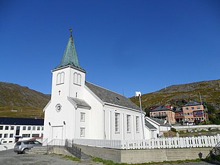
Honningsvåg Church is a parish church of the Church of Norway in Nordkapp Municipality in Finnmark county, Norway. It is located in the town of Honningsvåg on the eastern end of the island of Magerøya. It is one of the churches for the Nordkapp parish which is part of the Hammerfest prosti (deanery) in the Diocese of Nord-Hålogaland. The white, neo-gothic, wooden church was built in a long church style in 1885 using plans drawn up by the architect Jacob Wilhelm Nordan. The church seats about 220 people.


