Related Research Articles

Sutton Hoo is the site of two Anglo-Saxon cemeteries dating from the 6th to 7th centuries near Woodbridge, Suffolk, England. Archaeologists have been excavating the area since 1938, when an undisturbed ship burial containing a wealth of Anglo-Saxon artifacts was discovered. The site is important in establishing the history of the Anglo-Saxon kingdom of East Anglia as well as illuminating the Anglo-Saxons during a period which lacks historical documentation.
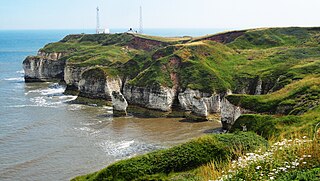
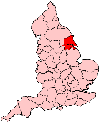
The East Riding of Yorkshire, often abbreviated to the East Riding or East Yorkshire, is a ceremonial county in the Yorkshire and the Humber region of England. It borders North Yorkshire to the north and west, South Yorkshire to the south-west, and Lincolnshire to the south across the Humber Estuary. The city of Kingston upon Hull is the largest settlement.
Humberside was a non-metropolitan and ceremonial county in Northern England from 1 April 1974 until 1 April 1996. It was composed of land from either side of the Humber, created from portions of the East Riding of Yorkshire, West Riding of Yorkshire, and the northern part of Lindsey, Lincolnshire. The county council's headquarters was County Hall at Beverley, inherited from East Riding County Council. Its largest settlement and only city was Kingston upon Hull. Other notable towns included Goole, Beverley, Scunthorpe, Grimsby, Cleethorpes and Bridlington. The county stretched from Wold Newton at its northern tip to a different Wold Newton at its southernmost point.

John Robert Mortimer was an English corn-merchant and archaeologist who lived in Driffield, East Riding of Yorkshire.

Jarlshof is the best-known prehistoric archaeological site in Shetland, Scotland. It lies in Sumburgh, Mainland, Shetland and has been described as "one of the most remarkable archaeological sites ever excavated in the British Isles". It contains remains dating from 2500 BC up to the 17th century AD.

Torksey is a small village in the West Lindsey district of Lincolnshire, England. The population of the civil parish at the 2011 census was 875. It is situated on the A156 road, 7 miles (11 km) south of Gainsborough and 9 miles (14 km) north-west of Lincoln, and on the eastern bank of the tidal River Trent, which here forms the boundary with Nottinghamshire.
Yorkshire is a historic county of England, centred on the county town of York. The region was first occupied after the retreat of the ice age around 8000 BC. During the first millennium AD it was inhabited by celtic Britons and occupied by Romans, Angles and Vikings. The name comes from "Eborakon" an old Brythonic name which probably derives from "Efor" or "the place of the yew-trees." Many Yorkshire dialect words and aspects of pronunciation derive from old Norse due to the Viking influence in this region. The name "Yorkshire", first appeared in writing in the Anglo-Saxon Chronicle in 1065. It was originally composed of three sections called Thrydings, subsequently referred to as Ridings.
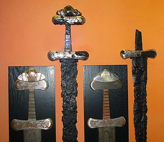
The Viking Age sword or Carolingian sword is the type of sword prevalent in Western and Northern Europe during the Early Middle Ages.

Brough is a town in the East Riding of Yorkshire, England. It is part of the civil parish of Elloughton-cum-Brough with the neighbouring village of Elloughton. Brough is situated on the northern bank of the Humber Estuary, approximately 12 miles (19 km) west of Hull city centre. Brough has a long association with BAE Systems.

Stanwick Iron Age Fortifications, a huge Iron Age hill fort, sometimes but not always considered an oppidum, comprising over 9 kilometres (5.6 mi) of ditches and ramparts enclosing approximately 300 hectares of land, are situated in Richmondshire, North Yorkshire, England. Whether Stanwick was the stronghold of Venutius or Cartimandua, or perhaps of them both for a brief time before their acrimonious split some time after 51 AD, it is certain that this settlement was one of the most important in Brigantia, the Brigantes kingdom during the early stages of the Roman occupation of Britain. The site is a scheduled monument.
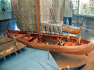
A knarr is a type of Norse merchant ship used by the Vikings for long sea voyages and during the Viking expansion. The knarr was a cargo ship; the hull was wider, deeper and shorter than a longship, and could take more cargo and be operated by smaller crews. It was primarily used to transport trading goods like walrus ivory, wool, timber, wheat, furs and pelts, armour, slaves, honey, and weapons. It was also used to supply food, drink, weapons and armour to warriors and traders along their journeys across the Baltic, the Mediterranean and other seas. Knarrs routinely crossed the North Atlantic carrying livestock such as sheep and horses, and stores to Norse settlements in Iceland, Greenland and Vinland as well as trading goods to trading posts in the British Isles, Continental Europe and possibly the Middle East. The knarr was constructed using the same clinker-built method as longships, karves, and faerings.

Brantingham is a village and civil parish in the East Riding of Yorkshire, England, about 2 miles (3 km) north of Brough, 12 miles (19 km) west of Hull and north of the A63 road. The 2011 UK Census gave the parish had a population of 370, marking a decrease from the 2001 UK census figure of 410. The 2019 estimate was 319.

Skerne is a village and former civil parish, now in the parish of Skerne and Wansford, in the East Riding of Yorkshire, England. The village is situated 1 mile (1.6 km) to the south of the River Hull and the Driffield Canal. It is approximately 2 miles (3 km) south-east from Driffield and 2 miles north-east from Hutton Cranswick.
Petuaria was originally a Roman fort situated where the town of Brough in the East Riding of Yorkshire now stands. Petuaria means something like 'quarter' or 'fourth part', incorporating the archaic Brythonic *petuar, 'four'.

The Museum of Archaeology, founded in 1833, is the archaeology museum of Durham University in England and was the second university museum in England to be open to the public. It is mostly focused on the archaeology of north east England with some national and international artefacts. The collections range from the prehistoric to the post-medieval, including the internationally important Oswald-Plique collection of Samian ware and the first complete Roman fleet diploma to be found in Britain. It is the repository for development-led archaeology finds in Durham City.
The East Riding of Yorkshire is a local government district with unitary authority status, and is a ceremonial county of England. It is named after the historic East Riding of Yorkshire which was one of three ridings alongside the North Riding and West Riding, which were constituent parts a Yorkshire ceremonial and administrative county until 1974. From 1974 to 1996 the area of the modern East Riding of Yorkshire constituted the northern part of Humberside.
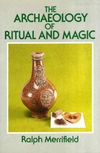
The Archaeology of Ritual and Magic is an archaeological study of the material evidence for ritual and magical practices in Europe, containing a particular emphasis on London and South East England. It was written by the English archaeologist Ralph Merrifield, the former deputy director of the Museum of London, and first published by B.T. Batsford in 1987.

Thomas Sheppard was a British museum curator and amateur geologist, who founded several museums in Kingston upon Hull and in the East Riding of Yorkshire, England.

The Hull and East Riding Museum of Archaeology is located in the Museums Quarter of the Old Town in Kingston upon Hull, England. It dates back to 1925 as the Museum of Commerce and Industry in a former Customs House but acquired its present name in 1989 with a major refurbishment and new entrance, with the transport section moving to a separate museum. It displays items from prehistoric to medieval in the area, many of them in life-size tableaux or reconstructions of rooms and buildings.

A prominent position was held by wetlands and islands in Germanic paganism, as in other pagan European cultures, featuring as sites of religious practice and belief from the Nordic Bronze Age until the Christianisation of the Germanic peoples.
References
- 1 2 "Skerne Sword". Hull Museums and Gallery. Retrieved 29 July 2024.
- ↑ Dent, John (1984). "Skerne". Current Archaeology. No. 91. pp. 251–253.
- 1 2 Webster, L. (1982). "Exhibits at Ballots: 2. A Viking Age sword from Skerne, N. Humberside". Antiquaries Journal. 62 (2): 38.
- ↑ Lund, Julie (2005). "Thresholds and Passages: The Meanings of Bridges and Crossings in the Viking Age and Early Middle Ages". Viking and Medieval Scandinavia. 1: 109–135.
- ↑ Raffield, B. (2014). "'A River of Knives and Swords': Ritually Deposited Weapons in English Watercourses and Wetlands during the Viking Age". European Journal of Archaeology. 17 (4): 634–655. doi:10.1179/1461957114Y.0000000066.