Lissett is a village and former civil parish, now in the parish of Ulrome, in the Holderness area of the East Riding of Yorkshire, England. It is situated 6 miles (10 km) south of Bridlington town centre and 13 miles (21 km) north-east of Beverley town centre on the A165 road that connects the two towns. In 1931 the parish had a population of 95.

Garton on the Wolds is a village and a civil parish on the Yorkshire Wolds in the East Riding of Yorkshire, England. It is situated approximately 3 miles (5 km) north-west of Driffield town centre and lies on the A166 road.

Harpham is a small village and civil parish in the East Riding of Yorkshire, England. It is located just south of the A614 road, approximately 5 miles (8 km) north-east of Driffield and 7 miles (11 km) south-west of Bridlington.

Hotham is a small village and civil parish in the East Riding of Yorkshire, England. It is situated approximately 16 miles (26 km) west of Hull, 21 miles (34 km) south east of York and 4 miles (6 km) south of Market Weighton town centre. The village has road links with the cities of Kingston upon Hull, York and Leeds. The eastern end of the M62 motorway, at Junction 38, is 2 miles (3 km) south-west from Hotham.

West Beck is the common name given to the upper section of the old River Hull, as it rises in the foothills of the Yorkshire Wolds. After reaching Frodingham Beck at Emmotland, it becomes called the River Hull. It is noteworthy for being the most northerly chalk stream in England. It provides fly fishing for wild brown trout and grayling.

North Newbald is a village and former civil parish, now in the parish of Newbald, in the East Riding of Yorkshire, England. The village is situated approximately 13 miles (20 km) north-west of Hull city centre, 3 miles (5 km) north of South Cave and 3.5 miles (6 km) south of Market Weighton. It lies to the east of the A1034 road.

Gembling is a hamlet and former civil parish, now in the parish of Foston, in the East Riding of Yorkshire, England. It is situated approximately 8 miles (13 km) south-west from the coastal resort of Bridlington and 2.5 miles (4 km) north from the village of North Frodingham. In 1931 the parish had a population of 80.

South Dalton is a village and former civil parish, now in the parish of Dalton Holme, in the East Riding of Yorkshire, England. It is situated 6 miles (10 km) north-east of Market Weighton and 5 miles (8 km) north-west of Beverley. Etton lies 2 miles (3.2 km) to the south-east. North Dalton is 5 miles (8 km) north-west, with the villages of Middleton on the Wolds and Lund between. In 1931 the parish had a population of 233. On 1 April 1935 the parish was abolished and merged with Holme on the Wolds to form "Dalton Holme".

Wansford is a village and former civil parish, now in the parish of Skerne and Wansford, in the East Riding of Yorkshire, England. It is situated on the B1249 road and just to the north of the River Hull and the Driffield Canal. It is approximately 2.5 miles (4 km) south-east of Driffield and 3 miles (4.8 km) north-west of North Frodingham.

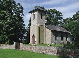
Scorborough is a village and former civil parish, now in the parish of Leconfield, in the East Riding of Yorkshire, England. It is situated on the A164 road, about 4 miles (6.4 km) north of Beverley and 8 miles (13 km) south of Driffield. In 1931 the parish had a population of 85. On 1 April 1935 the parish was abolished and merged with Leconfield.

North Frodingham is a village and civil parish in the East Riding of Yorkshire, England. It is situated approximately 5.5 miles (9 km) south-east of the town of Driffield and lies on the B1249 road.
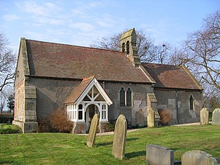
Lowthorpe is a village and former civil parish, now in the parish of Harpham, in the East Riding of Yorkshire, England. It is situated approximately 3 miles (5 km) north-east of Driffield town centre and 7 miles (11 km) south-west of Bridlington town centre. In 1931 the parish had a population of 159. On 1 April 1935 the parish was abolished and merged with Harpham.

Lelley is a small village in the civil parish of Elstronwick, in the East Riding of Yorkshire, England, in an area known as Holderness. It is situated approximately 7 miles (11 km) north-east of Kingston upon Hull city centre and 3 miles (5 km) north of Hedon.

Skerne and Wansford is a civil parish in the East Riding of Yorkshire, England. It is situated approximately 2 miles (3.2 km) south-east of the town of Driffield and covering an area of 1,493.224 hectares.

Hilston is a village in the civil parish of Roos, in the East Riding of Yorkshire, England, near the North Sea coast in an area known as Holderness. It is situated approximately 12 miles (19 km) east of Kingston upon Hull city centre and 5 miles (8 km) north-west of Withernsea. It lies to the east of the B1242 road. In 1931 the parish had a population of 27.

Hempholme is a hamlet in the civil parish of Brandesburton, in Holderness, in the East Riding of Yorkshire, England. It is situated approximately 8 miles (13 km) north-east of Beverley town centre, and 1 mile (1.6 km) east of the Driffield Navigation.

Harswell is a village and former civil parish, now in the parish of Everingham, in the East Riding of Yorkshire, England. It is approximately 3.5 miles (5.6 km) west of Market Weighton town centre, 5 miles (8 km) south of Pocklington town centre, and 1 mile (1.6 km) west of the A614 road. In 1931 the parish had a population of 78.
Goxhill is a small hamlet in the civil parish of Hatfield, in the East Riding of Yorkshire, England in an area known as Holderness. It is situated approximately 2 miles (3.2 km) south-west of Hornsea town centre. In 1931 the parish had a population of 70.

Foston on the Wolds is a village and civil parish in the East Riding of Yorkshire, England. It is situated approximately 8 miles (13 km) south-west of Bridlington town centre and 2 miles (3 km) north of the village of North Frodingham.

Cowlam is a hamlet in the civil parish of Cottam, in the East Riding of Yorkshire, England, and in the Yorkshire Wolds. The hamlet is on the B1253 Bridlington to North Grimston road, 17 miles (30 km) north from the county town of Beverley, 2 miles (3 km) east from the village of Sledmere, and 2.5 miles (4 km) north-west from the parish hamlet of Cottam. The hamlet contains eight houses and two farms.

