Lissett is a village and former civil parish, now in the parish of Ulrome, in the Holderness area of the East Riding of Yorkshire, England. It is situated 6 miles (10 km) south of Bridlington town centre and 13 miles (21 km) north-east of Beverley town centre on the A165 road that connects the two towns. In 1931 the parish had a population of 95.

Garton on the Wolds is a village and civil parish on the Yorkshire Wolds in the East Riding of Yorkshire, England. It is situated approximately 3 miles (5 km) north-west of Driffield town centre and lies on the A166 road.

Sledmere is a village in the East Riding of Yorkshire, England, about 7 miles (11 km) north-west of Driffield on the B1253 road.
Aike is a hamlet and former civil parish, now in the parish of Lockington, in the East Riding of Yorkshire, England. The hamlet is centred around a single developed street, which lies to the east of the Yorkshire Wolds. Aike is approximately 4 miles (6 km) north of Beverley and approximately 0.4 miles (1 km) from the west bank of the River Hull. It is approached by a 2.5-mile (4 km) lane which is a no-through road that does not continue beyond the village, although a farm track continues as far as a bridge across the Beverley and Barmston Drain. In 1931 the parish had a population of 48.

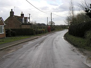
Brigham is a small village and former civil parish, now in the parish of Foston on the Wolds, in the East Riding of Yorkshire, England. It is situated approximately 4 miles (6 km) south-east from Driffield, 15 miles (24 km) north of Hull city centre, and to the west of the B1249 road. In 1931 the parish had a population of 66. Brigham was formerly a township in the parish of Foston on the Wolds, from 1866 Brigham was a civil parish in its own right, on 1 April 1935 the parish was abolished to form Foston.

North Newbald is a village and former civil parish, now in the parish of Newbald, in the East Riding of Yorkshire, England. The village is situated approximately 13 miles (20 km) north-west of Hull city centre, 3 miles (5 km) north of South Cave and 3.5 miles (6 km) south of Market Weighton. It lies to the east of the A1034 road.

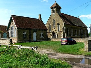
Gembling is a hamlet and former civil parish, now in the parish of Foston, in the East Riding of Yorkshire, England. It is situated approximately 8 miles (13 km) south-west from the coastal resort of Bridlington and 2.5 miles (4 km) north from the village of North Frodingham. In 1931 the parish had a population of 80.
Towthorpe is a hamlet and former civil parish, now in the parish of Fimber, in the East Riding of Yorkshire, England. It is situated in the Yorkshire Wolds just north of the B1248 road, approximately 8 miles (13 km) north-west of Driffield and 2 miles (3 km) south-west of Sledmere. In 1931 the parish had a population of 66. The deserted medieval village is a scheduled monument.
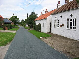
North Cliffe is a hamlet and former civil parish, now in the parish of South Cliffe, in the East Riding of Yorkshire, England. It is situated about 3 miles (5 km) north of North Cave, 2 miles (3.2 km) west of Newbald and 3 miles south of Market Weighton. The hamlet bestrides Cliffe Road. On the eastern side lies the houses, and to the west is a small church/chapel. In 1931 the parish had a population of 71.

Skerne is a village and former civil parish, now in the parish of Skerne and Wansford, in the East Riding of Yorkshire, England. The village is situated 1 mile (1.6 km) to the south of the River Hull and the Driffield Canal. It is approximately 2 miles (3 km) south-east from Driffield and 2 miles north-east from Hutton Cranswick.

Scorborough is a village and former civil parish, now in the parish of Leconfield, in the East Riding of Yorkshire, England. It is situated on the A164 road, about 4 miles (6.4 km) north of Beverley and 8 miles (13 km) south of Driffield. In 1931 the parish had a population of 85. On 1 April 1935 the parish was abolished and merged with Leconfield.
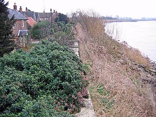
Saltmarshe is a hamlet and former civil parish, now in the parish of Laxton, in the East Riding of Yorkshire, England. It is situated on the north bank of the River Ouse, downstream from York, Selby and Goole. Saltmarshe is approximately 3 miles (5 km) south-east from Howden and 21 miles (34 km) south-east from York. In 1931 the parish had a population of 82.

Rotsea is a hamlet and former civil parish, now in the parish of Hutton Cranswick, in the East Riding of Yorkshire, England. It is situated approximately 4.5 miles (7.2 km) south-east of Driffield and 2.5 miles (4 km) south-west of North Frodingham. In 1931 the parish had a population of 29.
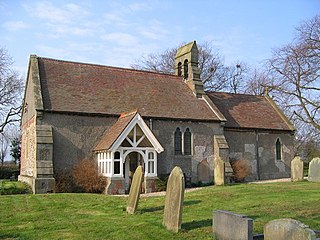
Lowthorpe is a village and former civil parish, now in the parish of Harpham, in the East Riding of Yorkshire, England. It is situated approximately 3 miles (5 km) north-east of Driffield town centre and 7 miles (11 km) south-west of Bridlington town centre. In 1931 the parish had a population of 159. On 1 April 1935 the parish was abolished and merged with Harpham.

Low Catton is a village and former civil parish, now in the parish of Catton, in the East Riding of Yorkshire, England. It is situated approximately 7 miles (11 km) north-west of the market town of Pocklington and about 1 mile (1.6 km) south of the village of Stamford Bridge. In 1931 the parish had a population of 85. Low Catton became a civil parish in 1866, on 1 April 1935 the parish was abolished and merged with High Catton to form "Catton".

Eastburn is a hamlet and former civil parish, now in the parish of Kirkburn, in the East Riding of Yorkshire, England. It is situated in the Yorkshire Wolds on the A164 road, approximately 2.5 miles (4 km) south-west of Driffield town centre and 3 miles (5 km) north-west of the village of Hutton Cranswick. In 1931 the parish had a population of 27.

Haisthorpe is a village and former civil parish, now in the parish of Carnaby, in the East Riding of Yorkshire, England. It is situated approximately 4 miles (6 km) south-west of Bridlington town centre. It lies on the A614. In 1931 the parish had a population of 127.

Fridaythorpe is a village and civil parish in the East Riding of Yorkshire, England. It is situated approximately 8 miles (13 km) north-east of Pocklington town centre and lies on the A166 road. It is 550 feet (170 m) above sea level, making it the highest village in the Yorkshire Wolds.

Butterwick is a village and former civil parish, now in the parish of Foxholes (1.75 miles to the east, near the village of Weaverthorpe, in North Yorkshire, England. The village lies in the Great Wold Valley and the course of the winterbourne stream the Gypsey Race passes through it. Until 1974 the village lay in the historic county boundaries of the East Riding of Yorkshire. From 1974 to 2023 it was part of the Ryedale district.

Whitley Lower is a village near Thornhill in Kirklees, West Yorkshire England. The parish church, dedicated to St Mary and St Michael, is part of the united benefice of Thornhill and Whitley which also includes Briestfield. The church was Grade II listed in 1985. In 1891 the civil parish had a population of 879.


