Related Research Articles

Issaquena County is a county located in the U.S. state of Mississippi. As of the 2020 Census, its population was 1,338, making it the least populous county in the United States east of the Mississippi River. Its county seat is Mayersville. With a per-capita income of $18,598, Issaquena County is, by that measure, one of the poorest counties in the United States.

Bolivar County is a county located on the western border of the U.S. state of Mississippi. As of the 2020 census, the population was 30,985. Its county seats are Rosedale and Cleveland. The county is named in honor of Simón Bolívar, early 19th-century leader of the liberation of several South American territories from Spain.

Shelby is a city in Bolivar County, Mississippi, United States. The population was 2,229 at the 2010 census, down from 2,926 in 2000. The town of Shelby was established in 1853 by Tom Shelby, who had purchased a block of land there from the federal government.

Des Allemands is an unincorporated community and census-designated place (CDP) in Lafourche and St. Charles parishes in the southeastern part of the U.S. state of Louisiana. The population was 2,179 at the 2020 census. The town, known as the "Catfish Capital of the Universe", is along the Bayou des Allemands, which is the boundary of Lafourche and St. Charles parishes. Lac des Allemands is located northwest of the town. The ZIP Code for Des Allemands is 70030.
Bayou Teche is a 125-mile-long (201 km) waterway in south central Louisiana in the United States. Bayou Teche was the Mississippi River's main course when it developed a delta about 2,800 to 4,500 years ago. Through a natural process known as deltaic switching, the river's deposits of silt and sediment cause the Mississippi to change its course every thousand years or so.

Bayou Lafourche, originally called Chetimachas River or La Fourche des Chetimaches,, is a 106-mile-long (171 km) bayou in southeastern Louisiana, United States, that flows into the Gulf of Mexico. The bayou is flanked by Louisiana Highway 1 on the west and Louisiana Highway 308 on the east, and is known as "the longest Main Street in the world." It flows through parts of Ascension, Assumption, and Lafourche parishes. Today, approximately 300,000 Louisiana residents drink water drawn from the bayou.

The Tallahatchie River is a river in Mississippi which flows 230 miles (370 km) from Tippah County, through Tallahatchie County, to Leflore County, where it joins the Yalobusha River to form the Yazoo River, which ultimately meets the Mississippi River at Vicksburg, Mississippi. The river is navigable for about 100 miles (160 km). At Money, Mississippi, the river's flow measures approximately 7,861 cubic feet per second.
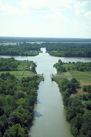
Vicksburg National Military Park preserves the site of the American Civil War Battle of Vicksburg, waged from March 29 to July 4, 1863. The park, located in Vicksburg, Mississippi, flanking the Mississippi River, also commemorates the greater Vicksburg Campaign which led up to the battle. Reconstructed forts and trenches evoke memories of the 47-day siege that ended in the surrender of the city. Victory here and at Port Hudson, farther south in Louisiana, gave the Union control of the Mississippi River.
Border irregularities of the United States, particularly panhandles and highway incursions into other jurisdictions, are shown here. Often they are a result of borders which do not conform to geological features such as changes in the course of a river that previously marked a border.
Chickasaw Bayou is a stream in the U.S. state of Mississippi. It is a tributary to the Yazoo River.
Black Bayou is a 66.6-mile-long (107.2 km) river in Texas and Louisiana. It is a tributary of Twelvemile Bayou, which feeds Cross Bayou and consequently the Red River and the Mississippi River. It rises in Cass County, Texas, 7 miles (11 km) north of Atlanta, and flows south past Atlanta, then southeast into Caddo Parish, Louisiana. It continues southeast until reaching the Red River floodplain, then curves south and southwest to its confluence with the outlet of Caddo Lake, where Twelvemile Bayou is formed.

Cross Bayou is a 38.0-mile-long (61.2 km) river in Texas and Louisiana. It is a tributary of the Red River, part of the Mississippi River watershed.

The Steele's Bayou expedition was a joint operation of Major General Ulysses S. Grant's Army of the Tennessee and Rear Admiral David D. Porter's Mississippi River Squadron, conducted as a part of the Vicksburg Campaign of the American Civil War. Its aim was to move Union forces from the Mississippi River to a point on the Yazoo River upstream of Confederate Lieutenant General John C. Pemberton's defenses of Vicksburg. To avoid enemy artillery in place on the bluffs to the east of the city, the expedition would leave the Yazoo and proceed indirectly on a route through a series of waterways in the flood plain to the east of the Mississippi.
WKXY is a radio station airing a country music format. The station is licensed to Merigold, Mississippi. WKXY is owned by Delta Radio Network LLC. The WKXY studio is located at 3965 Highway 61 North in Cleveland, Mississippi, and the transmitter site is located on East Mound Bayou Road, near the town of Mound Bayou, Mississippi.
James Bayou Township is an inactive township in Mississippi County, in the U.S. state of Missouri.
Choctaw Creek is a stream in the U.S. state of Mississippi. It is a tributary to Bayou Pierre.
Pelucia Bayou is a stream in the U.S. state of Mississippi.
Tippo Bayou is a stream in the U.S. state of Mississippi.
Tokeba Bayou is a stream in the U.S. state of Mississippi.
Northside High School is a public secondary school in Shelby, Mississippi, serving grades 7–12. It is the only high school of the North Bolivar Consolidated School District. The district serves, in addition to Shelby: Alligator, Duncan, Mound Bayou, and Winstonville. The alligator is the mascot. The school colors are blue and orange.
References
- 1 2 U.S. Geological Survey Geographic Names Information System: Skillikalia Bayou
- ↑ Baca, Keith A. (2007). Native American Place Names in Mississippi. University Press of Mississippi. p. 96. ISBN 978-1-60473-483-6.
32°29′31″N90°48′17″W / 32.4918077°N 90.8048249°W