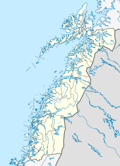
Fauske (Norwegian) or Fuossko (Lule Sami) is a municipality located in Nordland county, Norway. It is part of the traditional district of Salten. The administrative centre of the municipality is the town of Fauske. Some of the villages in Fauske include Nystad, Venset, Straumsnes, and Sulitjelma.

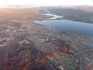
Rognan is a village and the administrative centre of the municipality of Saltdal in Nordland county, Norway. The village is located at the innermost part of Skjerstad Fjord, called Saltdal Fjord. It is located about 15 kilometres (9.3 mi) north of the village of Røkland.

Salten is a traditional district in Nordland county, Norway. It includes the municipalities of Meløy, Gildeskål, Bodø, Beiarn, Saltdal, Fauske, Sørfold, Steigen, and Hamarøy. Salten covers an area of about 9,354 square kilometres (3,612 sq mi) and has a population (2016) of about 73,375 people.

Nedrevatnet or Nervatnet is a lake that lies in Fauske Municipality in Nordland county, Norway. The 4.8-square-kilometre (1.9 sq mi) lake lies just east of the town of Fauske. The lake Øvrevatnet flows into this lake and the water flows out of the Nedrevatnet into the Skjerstad Fjord. The European route E06 highway and the Nordland Line run along the western edge of this lake.

Straumsnes or Strømsnes is a village in the municipality of Fauske in Nordland county, Norway. It is located in the Valnesfjord area of Fauske. The town of Fauske lies 15 kilometres (9.3 mi) to the east and the town of Bodø lies about 40 kilometres (25 mi) to the west. The village sits just inland of Skjerstad Fjord, along the southern shore of the lake Valnesfjordvatnet.

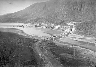
The Sulitjelma Line was a railway line that ran between Finneid in the town of Fauske to the village of Sulitjelma near the border with Sweden. The railway line was entirely inside the municipality of Fauske in Nordland county, Norway. The line was built in 1891, over time it was lengthened until 1958 when it was connected to the Nordland Line and the sea port at Finneid. It existed as a branch of the Nordland Line from 1958 until 1972 when the line was closed and removed. The railway line followed the path of the present-day Norwegian County Road 830.
The Polar Line is an incomplete and abandoned railway line from Fauske, Norway, to Narvik and, if finished, ultimately would have run 1,215 km (755 mi) to Kirkenes.

Sjunkhatten National Park was established in 2010 in Nordland county, Norway. The park consists of a 417.5-square-kilometre (161.2 sq mi) continuously protected area, including 39.8-square-kilometre (15.4 sq mi) sea area in the municipalities of Bodø, Fauske, and Sørfold. The park is located on a peninsula between the Sørfolda fjord and Saltfjorden, including glacier-formed landscape, caves and water systems, fjords, the large lake Heggmovatnet, rare animal species, and cultural heritage.
Saltfjorden or Saltenfjorden is a fjord in the municipalities of Bodø and Gildeskål in Nordland county, Norway. The 40-kilometre (25 mi) long fjord begins around the Fleinvær islands; travels northeast past the islands of Sørarnøya, Sandhornøya, and Straumøya islands; along the southern shores of the town of Bodø; and ends at the village of Løding.
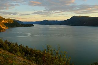
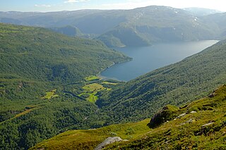
Saltdal Fjord is a fjord arm of Skjerstad Fjord in the municipality of Saltdal in Nordland county, Norway. The fjord extends 11 kilometers (6.8 mi) south to the village of Rognan at the bottom of the fjord.
Lakså is an abandoned village with no road connection in a valley above Øvervatnet in the municipality of Fauske in Nordland county, Norway. There were two farms in the valley: Lakså on the shore of Lakså Bay and Nordal somewhat further up the valley.
Venset is a village in the municipality of Fauske in Nordland county, Norway. Venset lies on the north shore of Skjerstad Fjord about 17 kilometers (11 mi) west of the town of Fauske and about 6 kilometres (3.7 mi) south of the village of Valnesfjord.
The Røvik Tunnel is a road tunnel that is part of Norwegian National Road 80 in the municipality of Fauske in Nordland county, Norway. It runs parallel to the Nordland Line between Røvik and Valnesfjord, just west of the town of Fauske.

Sjønstå is a settlement in Norway and was officially a village during a brief time when Sulitjelma Mines carried out activity in the area, c. 1890 to 1956. Before this time, Sjønstå comprised the Sjønstå farm, which is located on Øvervatnet in the municipality of Fauske in Nordland county.
Fossen is a waterfall along the Sjønstå River in Nordland county, Norway. It is about 9 kilometers (5.6 mi) upriver from the Sjønstå farm in the municipality of Fauske.
Fauske is a town in Fauske Municipality in Nordland county, Norway. It is also the administrative centre of Fauske Municipality. The town is located on the shore of the Skjerstad Fjord, about 60 kilometres (37 mi) east of the town of Bodø and about 40 kilometres (25 mi) west of the border with Sweden. The lake Nervatnet lies on the southeast side of the town.

Skjerstad is a former municipality in Nordland county, Norway. The 465-square-kilometre (180 sq mi) municipality existed from 1838 until its dissolution in 2005. The municipality generally encompassed the area around the Misværfjorden in what is now Bodø Municipality, although it originally was much larger, also including the entire present-day Fauske Municipality. The administrative centre of Skjerstad municipality was the village of Misvær.

Knaplundsøya or Godøya is an island in Bodø Municipality in Nordland county, Norway. The 6.6-square-kilometre (2.5 sq mi) island lies just southeast of the town of Bodø, between the Saltfjorden and the Skjerstadfjorden. The island is connected to the mainland and the to the neighboring island of Straumøya by the Norwegian County Road 17. The Saltstraumen strait and its famous maelstrom are located between Straumøya and Knaplundsøya. The island had 392 residents in 2016, mostly living on the north and west shores of the island.