Skjoldafjorden

Last updated
Skjoldafjorden

Skjoldastraumen sluser3.jpg

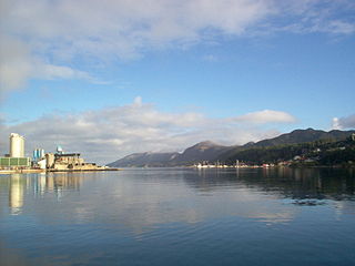
View of the locks along the fjord
Norway Rogaland location map.svg
Red pog.svg
Skjoldafjorden
Location in Rogaland county
Location Rogaland county, Norway
Coordinates 59°29′39″N5°34′40″E / 59.4943°N 5.5778°E / 59.4943; 5.5778 Coordinates: 59°29′39″N5°34′40″E / 59.4943°N 5.5778°E / 59.4943; 5.5778
Primary inflows Grindafjorden
Primary outflows Boknafjorden
Basin  countries Norway
Max. length 26 kilometres (16 mi)
Settlements Skjold

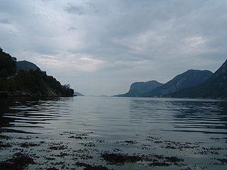
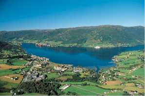
Skjoldafjorden is a fjord in Rogaland county, Norway. The 26-kilometre (16 mi) long fjord is a northern branch of vast Boknafjorden which dominates Rogaland county.

Fjord A long, narrow inlet with steep sides or cliffs, created by glacial activity

Geologically, a fjord or fiord is a long, narrow inlet with steep sides or cliffs, created by a glacier. There are many fjords on the coasts of Alaska, Antarctica, British Columbia, Chile, Greenland, the Faroe Islands, Iceland, Kamchatka, the Kerguelen Islands, New Zealand, Norway, Novaya Zemlya, Labrador, Nunavut, Newfoundland, Quebec, Scotland, South Georgia Island, and Washington state. Norway's coastline is estimated at 29,000 kilometres (18,000 mi) with nearly 1,200 fjords, but only 2,500 kilometres (1,600 mi) when fjords are excluded.

Rogaland County (fylke) of Norway

Rogaland[²ruːɡɑlɑn](listen) is a county in Western Norway, bordering Hordaland, Telemark, Aust-Agder, and Vest-Agder counties. Rogaland is the center of the Norwegian petroleum industry. In 2016, Rogaland had an unemployment rate of 4.9%, one of the highest in Norway. In 2015, Rogaland had a fertility rate of 1.78 children per woman, which is the highest in the country.

Norway constitutional monarchy in Northern Europe

Norway, officially the Kingdom of Norway, is a Nordic country in Northwestern Europe whose territory comprises the western and northernmost portion of the Scandinavian Peninsula; the remote island of Jan Mayen and the archipelago of Svalbard are also part of the Kingdom of Norway. The Antarctic Peter I Island and the sub-Antarctic Bouvet Island are dependent territories and thus not considered part of the kingdom. Norway also lays claim to a section of Antarctica known as Queen Maud Land.

The fjord is located in the municipalities of Tysvær and Vindafjord. The north end of the Skjoldafjorden at the village of Skjold connects to the Grindafjorden which flows from the village of Grinde to Skjold. The south end of the fjord empties in to a large bay called the Hervikfjorden, which flows directly into the Boknafjorden.

Tysvær Municipality in Rogaland, Norway

Tysvær is a municipality in Rogaland county, Norway. It is part of the Haugalandet region. The municipality is located on the Haugalandet peninsula on the northern side of the Boknafjorden, just east of the towns of Kopervik and Haugesund. The administrative centre of the municipality is the village of Aksdal. Other villages in the municipality include Dueland, Førre, Grinde, Hervik, Hindaråvåg, Nedstrand, Skjoldastraumen, Susort, Tysvær, and Yrke.

Vindafjord Municipality in Rogaland, Norway

Vindafjord is a municipality in Rogaland county, Norway. It is part of the traditional district of Haugaland. Since 2005, the administrative centre of the municipality has been the village of Ølensjøen, prior to that time it was the village of Sandeid. Other villages in the municipality include Bjoa, Imslandsjøen, Ølensvåg, Skjold, Vats, Vikebygd, and Vikedal. The municipality is centered on the Vindafjorden and Sandeidfjorden in the east and it lies north and east of the Skjoldafjorden in the west.

Skjold, Rogaland Village in Western Norway, Norway

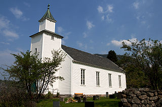
Skjold is a village in Vindafjord municipality in Rogaland county, Norway. The village is located at the northern end of the Skjoldafjorden, along the European route E134 highway, about 25 kilometres (16 mi) northeast of the town of Haugesund. Skjold Church is located in the village. The village was the administrative centre of the old municipality of Skjold which existed from 1838 until 1965.

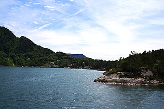
The island Borgøy is located at the mouth of the fjord where the Hervikfjorden begins. Further to the north, the narrow passage Skjoldastraumen has strong tide flows and is rather shallow. A lock system was built there to accommodate boat traffic. It is the only salt water lock in Norway. [1]

Borgøy

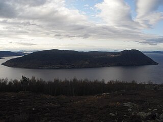
Borgøy is an island in Tysvær municipality in Rogaland county, Norway. The 4.5-square-kilometre (1.7 sq mi) island is located at the southern end of the Skjoldafjorden. South of the island lies the Hervikfjorden. The highest point on the island is the 292-metre (958 ft) tall mountain Borgøyhatten.

Skjoldastraumen Village in Western Norway, Norway

Skjoldastraumen is a village in Tysvær municipality in Rogaland county, Norway. The village is located along the Skjoldafjorden, about 10 kilometres (6.2 mi) east of the village of Grinde and about 5 kilometres (3.1 mi) northwest of the village of Yrke. The village lies on one of the narrowest parts of the fjord, where there is a set of locks on the fjord to raise and lower boats. The village is the site of the Skjoldastraumen Church.

Related Research Articles

Ombo island

Ombo is the largest island in the Ryfylke region on the southwestern coast of Norway, and is the second largest island in Rogaland county. The 57.5-square-kilometre (22.2 sq mi) island of Ombo is divided between the municipalities Hjelmeland and Finnøy. There are several villages on the island including Jørstadvåg, Atlatveit, and Eidssund in the western part of the island which belongs to Finnøy municipality. The villages of Tuftene, Skipavik, Skår, and Vestersjø are located on the southeastern part of the island which belongs to Hjelmeland municipality. Jørstad Church is located in the village of Jørstadvåg.

Fister Village in Western Norway, Norway

Fister is a village in Hjelmeland municipality in Rogaland county, Norway. The village is located on the mainland, along the Fisterfjorden, a branch off the main Boknafjorden. The village lies about 8 kilometres (5.0 mi) northwest of the village of Årdal and about 10 kilometres (6.2 mi) southwest of the municipal centre of Hjelmelandsvågen.

Tau, Norway Village in Western Norway, Norway

Tau is a village in Strand municipality in Rogaland county, Norway. The village is located on the shore of the Horgefjorden, a branch of the main Boknafjorden. The 2.11-square-kilometre (520-acre) village has a population (2015) of 3,158 which gives the village a population density of 1,497 inhabitants per square kilometre (3,880/sq mi). Strand Church is located in the village.

Boknafjord human settlement

Boknafjord or Boknafjorden is a fjord located in Rogaland county, Norway. The huge fjord lies between the cities Stavanger and Haugesund, and the main part of the fjord is shared between the municipalities of Kvitsøy, Rennesøy, Finnøy, Tysvær, Bokn, and Karmøy. There are dozens of smaller fjords that branch off the main part of the fjord, reaching most municipalities in the county. At its longest, the Boknafjord reaches about 96 kilometres (60 mi) into the mainland at the innermost point of the Hylsfjorden. Other notable branches include the Saudafjorden, Sandsfjorden, Vindafjorden, Hervikfjorden, Førresfjorden, Erfjorden, Jøsenfjorden, Årdalsfjorden, Idsefjorden, Høgsfjorden, Lysefjorden, and Gandsfjorden.

Gandsfjord

Gandsfjorden or Gandafjorden is a fjord in Rogaland county, Norway. The 13-kilometre (8.1 mi) long Gandsfjorden is an arm off of the large Boknafjorden. It runs between the mainland and the Stavanger Peninsula, along the shores of the cities of Stavanger and Sandnes, the third largest urban area in Norway. The entire west side of Gandsfjorden is highly developed and urban. The east side of the fjord has many mountains and peaks. In the outer parts of the fjord there are several islands including Uskjo, Hundvåg, Vassøy, and the Øyane islands of Stavanger.

Vostervatnet is a lake in the municipality of Strand in Rogaland county, Norway. The 2.62-square-kilometre (1.01 sq mi) lake lies in the northwestern part of Strand, just south of the Fognafjorden. The village of Tau lies about 3.5 kilometres (2.2 mi) southwest of the lake. The main outflow of the lake is the river Fiskåna, which flows north from the northeastern corner of the lake, down the hill to the village of Fiskå on the shore of the fjord.

Yrke Village in Western Norway, Norway

Yrke or Yrkje is a village in Tysvær municipality in Rogaland county, Norway. The village is located at the western end of the Yrkefjorden, a branch off of the main Vindafjorden. The village lies on a small isthmus between the Yrkefjorden and the Skjoldafjorden, along the County Road 515, the only road over the isthmus connecting the peninsula to the mainland. The village of Skjoldastraumen lies about 5 kilometres (3.1 mi) to the northwest and the villages of Hindaråvåg and Nedstrand lie about 20 kilometres (12 mi) to the southeast.

Sandsfjord fjord in Suldal, Norway

Sandsfjorden or Sandsfjord is a fjord in Suldal Municipality in Rogaland county, Norway. The 25-kilometre (16 mi) long fjord is the northernmost arm of main Boknafjorden in Rogaland county. The fjord begins at the confluence of the Saudafjorden and Hylsfjorden, just north of the village of Sand. It then travels to the southwest until it reaches the island of Foldøy, where the fjord joins the main Boknafjorden. The villages of Jelsa and Hebnes are located on either side of the mouth of the fjord.

Høgsfjorden

Høgsfjorden is a fjord in Rogaland county, Norway. The innermost part of the fjord is located at the village of Frafjord in the municipality of Gjesdal. It flows west to Dirdal and then heads northwards. At the village of Forsand, the Lysefjord branches off to the northeast. The Høgsfjorden continues to the northwest past the islands of Idsal and Idse before emptying into the Horgefjorden and ultimately into the vast Boknafjorden. The fjord runs through the municipalities of Gjesdal, Forsand, Sandnes, and Strand.

Hylsfjord

Hylsfjorden or Hylsfjord is a fjord in the municipality Suldal in Rogaland county, Norway. The 20-kilometre (12 mi) long fjord runs from the small area of Hylen to the west. It ends just north of the village of Sand where it joins the Saudafjorden and together they form the Sandsfjorden, an inner branch of the Boknafjorden. The 160-megawatt (210,000 hp) Hylen Hydroelectric Power Station is located in the inner end of Hylsfjord. The fjord has relatively little development along its shores, only a few small hamlets, with Vanvik being the largest.

Vindafjorden

Vindafjorden is a fjord in Rogaland county, Norway. The 30-kilometre (19 mi) long fjord is a northern branch off of the main Boknafjorden. The fjord marks the municipal boundaries between Vindafjord, Suldal, and Tysvær. The fjord initially runs from the very narrow Ropeid isthmus to the west and near the village of Vikadal, the fjord heads to the south before emptying into the Boknafjorden near the village of Nedstrand. There are two smaller fjords which branch off of the Vindafjorden. They are the Sandeidfjorden and the Yrkjefjorden. The deepest part of the fjord reaches about 580 metres (1,900 ft) below sea level, just off the shore from Imsland Church.

Skjold (municipality) Former Municipality in Western Norway, Norway

Skjold is a former municipality in Rogaland county, Norway. The 172-square-kilometre (66 sq mi) municipality encompassed all the area surrounding the Grindafjorden and Skjoldafjorden. The area is located in the present-day municipalities of Vindafjord and Tysvær. The administrative centre of the municipality was the village of Skjold where the Skjold Church is located.

Nedstrand (municipality) Former Municipality in Western Norway, Norway

Nedstrand is a former municipality in Rogaland county, Norway. The 119-square-kilometre (46 sq mi) municipality was located along the Nedstrandfjorden, an inner branch off the main Boknafjorden. The municipality encompassed the majority of the Nedstrand peninsula. Originally it also included the Sjernarøyane islands and the western part of the island of Ombo in the fjord to the south. The administrative centre of the municipality was the village of Nedstrand. Nedstrand Church is located in Hindaråvåg, a small village just west of Nedstrand village. Today, the area is part of the large municipality of Tysvær.

Byfjorden (Rogaland) fjord in Rogaland, Norway

Byfjorden is a fjord in Rogaland county, Norway. The 10-kilometre (6.2 mi) long fjord runs from the Tungenes Lighthouse at the northern end of the Stavanger Peninsula south along the east side of the peninsula to the city of Stavanger. It passes through the municipalities of Randaberg, Rennesøy, and Stavanger. The islands of Bru, Åmøy, Hundvåg, Buøy, Engøy, Sølyst, and Grasholmen lie along the east side of the fjord. The fjord connects to the Boknafjorden at the north end.

Åna-Sira Village in Western Norway, Norway

Åna-Sira is a village in southwestern Norway, sitting mostly in Sokndal municipality in Rogaland county, but a small portion lies in Flekkefjord municipality in Vest-Agder county. The village is located at the mouth of the river Sira where it flows south into Åna fjord. The fjord and river form the county border with Rogaland and Vest-Agder counties. The Åna-Sira Bridge crosses the river connecting the two parts of the village. The village is the southernmost village in Rogaland county.

References

  1. Godal, Anne Marit (ed.). "Skjoldafjorden". Store norske leksikon (in Norwegian). Norsk nettleksikon. Retrieved 23 July 2012.