
Santa Barbara County, California, officially the County of Santa Barbara, is a county located in the southern region of the U.S. state of California. As of the 2010 census, the population was 423,895. The county seat is Santa Barbara, and the largest city is Santa Maria.

Ventura County is a county in the southern part of the U.S. state of California. As of the 2010 census, the population was 823,318. The largest city is Oxnard, and the county seat is the city of Ventura.
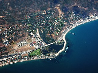
Malibu is a beach city in western Los Angeles County, California, situated about 30 miles (48 km) west of Downtown Los Angeles. It is known for its Mediterranean climate and its 21-mile (34 km) strip of the Malibu coast, incorporated in 1991 into the City of Malibu. The area is known for being the home of Hollywood movie stars, people in the entertainment industry, and other affluent residents. Most Malibu residents live within a few hundred yards of Pacific Coast Highway, which traverses the city, with some residents living up to a mile away from the beach up narrow canyons. As of the 2010 census, the city population was 12,645.

Santa Cruz Island is the largest of the eight islands in the Channel Islands and also the largest island in California, located off the coast of California. The island, in the northern group of the Channel Islands, is 22 miles (35 km) long and from 2 to 6 miles wide with an area of 61,764.6 acres (249.952 km2). Santa Cruz Island is located within Santa Barbara County, California. The coastline has steep cliffs, gigantic sea caves, coves, and sandy beaches. Defined by the United States Census Bureau as Block 3000, Block Group 3, Census Tract 29.10 of Santa Barbara County, the 2000 census showed an official population of two persons. The highest peak is Devils Peak, at 2450+ feet. It was the largest privately owned island off the continental United States but is currently jointly owned by the National Park Service (24%), and the Nature Conservancy (76%).

The Santa Clarita Valley is part of the upper watershed of the Santa Clara River in Southern California. The valley was part of the 48,612-acre (19,673 ha) Rancho San Francisco Mexican land grant. Located in Los Angeles County, its main population center is the city of Santa Clarita which includes the communities of Canyon Country, Newhall, Saugus, and Valencia. Adjacent unincorporated communities include Castaic, Stevenson Ranch, Val Verde, and the new master planned community of Newhall Ranch.

Topanga State Park is a California state park located in the Santa Monica Mountains, within Los Angeles County, California. It is part of the Santa Monica Mountains National Recreation Area.
Rattlesnake Canyon is the name of a number of scenic canyons in the Southwestern United States:

Mandeville Canyon is a small community in the Brentwood neighborhood of Los Angeles. Its center is Mandeville Canyon Road, which begins at Sunset Boulevard and extends north towards Mulholland Drive, though it stops short of Mulholland and there is no automotive route between the two. Mandeville Canyon Road is said to be the longest paved, dead end road in Los Angeles, at over 5 miles (8.0 km). From start to finish, the road gains 1,000 ft (300 m) in elevation.
Rustic Canyon is a residential neighborhood and canyon in eastern Pacific Palisades, on the west side of Los Angeles, California. It is along Rustic Creek, in the Santa Monica Mountains.

The Douglas Family Preserve is a public park in Santa Barbara, California. The Preserve is located on the mesa above Arroyo Burro Beach. The property spans 70 acres (280,000 m2) of undeveloped ocean-front land, and represents the largest area of coastal open space within the city limits of Santa Barbara.
Rattlesnake Canyon stretches from Skofield Park into the Santa Ynez mountains. Its name comes from its serpentine shape and curves, not rattlesnake occupation.

Eaton Canyon is a major canyon beginning at the Eaton Saddle near Mount Markham and San Gabriel Peak in the San Gabriel Mountains in the Angeles National Forest, United States. Its drainage flows into the Rio Hondo river and then into the Los Angeles River. It is named after Judge Benjamin S. Eaton, who lived in the Fair Oaks Ranch House in 1865 not far from Eaton Creek.

Alameda Park located in Santa Barbara, California, in the U.S., adjoining Alice Keck Park Memorial Gardens, is the location for many citywide celebrations, including Summer Solstice. It is also one of the city's oldest parks.
Bell Canyon Park is a large open-space regional park located in the Simi Hills at the western end of the San Fernando Valley in West Hills, Los Angeles and Bell Canyon, California. Bell Creek, a primary tributary to the Los Angeles River, flows through the park with riparian zone vegetation along its natural banks. The geographic landmark Escorpión Peak is high above it to the south in adjacent El Escorpión Park.

Santa Susana Pass State Historic Park is a California State Park of approximately 680 acres (2.8 km2) located on the boundary between Ventura and Los Angeles counties, between the communities of Chatsworth and Simi Valley. Geologically, the park is located where the Simi Hills meet the Santa Susana Mountains. Here in the western part of the Transverse Ranges, the land is dominated by high, narrow ridges and deep canyons covered with an abundant variety of plant life. The park offers panoramic views of the rugged natural landscape as a striking contrast to the developed communities nearby. The park is also rich in archaeological, historical and cultural significance.

Soquel Canyon State Marine Conservation Area (SMCA) is an offshore marine protected area in Monterey Bay. Monterey Bay is on California’s central coast with the city of Monterey at its south end and the city of Santa Cruz at its north end. The SMCA covers 23.41 square miles (60.6 km2). Within the SMCA, fishing and taking of any living marine resources is prohibited except the commercial and recreational take of pelagic finfish.

Big Sycamore Canyon, often shortened to Sycamore Canyon, is a major feature of Point Mugu State Park, in Ventura County, California, United States. Sycamore Canyon is situated in the northernmost region of the Santa Monica Mountains National Recreation Area below the 3,000 feet (910 m) peaks of the Boney Mountain State Wilderness Area. The canyon begins on the north slope of Boney Mountain and heads north down the slope. The canyon then heads southwest past Rancho Sierra Vista/Satwiwa to Sycamore Cove on the coastline.

Wheeler Springs is an unincorporated community in Ventura County, California. It is located 6 miles north of the Ojai Valley, within Los Padres National Forest. It is named for Wheeler Blumberg, who was the founder of town in 1891, and the many natural hot springs.

Our Lady of Sorrows Church is a Catholic church within the City of Santa Barbara, California in the United States that was built in 1929. The Church was listed as a designated landmark of the City of Santa Barbara on May 17, 2016.


