
Vadsø is a municipality in Finnmark County, Norway. The administrative centre of the municipality is the town of Vadsø, which is also the administrative centre of Finnmark county. Other settlements in Vadsø include Ekkerøy, Kiby, Krampenes, Skallelv, Valen, and Vestre Jakobselv.

Sør-Varanger is a municipality in Finnmark county, Norway. The administrative centre of the municipality is the town of Kirkenes. Other settlements in the municipality include the villages of Bjørnevatn, Bugøynes, Elvenes, Grense Jakobselv, Hesseng, Jakobsnes, Neiden, and Sandnes. Located west of the Norway–Russia border, Sør-Varanger is the only Norwegian municipality that shares a land border with Russia, with the only legal border crossing at Storskog.

Lommedalen is a rural community in a small valley in Bærum municipality in the county of Akershus, Norway. The population is about 3,000 people. Lommedalen valley opens up at Bærums Verk and runs about 5 kilometers to the north.

The Paatsjoki River is a river that flows through Finland, Norway, and Russia. Since 1826, the river has marked parts of the Norway–Russia border, except from 1920 to 1944 when it was along the Finland–Norway border.
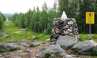
Treriksrøysa is a cairn which marks the tripoint where the borders between Norway, Finland, and Russia meet. The site is on a hill called Muotkavaara, in the Pasvikdalen valley, west of the Pasvikelva river and 15 km (9 mi) southwest of Nyrud just west of Krokfjellet in Sør-Varanger Municipality in Finnmark county, Norway. It is the only place in Europe where three time zones meet: Central European Time, Eastern European Time and Further-eastern European Time. The tripoint can only legally be approached by the public from the Norwegian side, since both Finland and Russia maintain extensive border zones where public access is prohibited.
Øvre Pasvik National Park is located in the southeastern part of the Pasvikdalen valley in southern Sør-Varanger Municipality in Finnmark county, Norway. Covering an area of 119 square kilometers (46 sq mi), the national park is dominated by Siberian-like taiga consisting of old-growth forests of Scots pine, shallow lakes and bog. Proposals for a national park in Øvre Pasvik were first launched in 1936, but the park was not created until 6 February 1970. It originally covered 66 square kilometers (25 sq mi), but was expanded on 29 August 2003. Øvre Pasvik is part of Pasvik–Inari Trilateral Park along with the adjacent Øvre Pasvik Landscape Protection Area, the joint Norwegian and Russian Pasvik Nature Reserve, and Finland's Vätsäri Wilderness Area.
Klistervatnet (Norwegian) or Клистерватн (Russian) is a lake that lies on the border between Norway and Russia. The 17.2-square-kilometre (6.6 sq mi) lake lies on the river Pasvikelva in Sør-Varanger Municipality in Finnmark county, Norway and the Pechengsky District of Murmansk Oblast in Russia. The lake is about 10 kilometres (6.2 mi) long and 2 kilometres (1.2 mi) wide. The lake is located north of lake Bjørnevatnet.

Gjevillvatnet is a lake in the municipality of Oppdal in Trøndelag county, Norway. It is located in the Trollheimen mountain range, about 5 kilometres (3.1 mi) south of the mountain Blåhøa and about 5 kilometres (3.1 mi) northwest of the village of Vognillan.
Sydvaranger AS is an iron ore mining company in Sør-Varanger Municipality, Norway. The mining operations have not restarted. With an open-pit mine in Bjørnevatn, it has traditionally hauled the ore with the Kirkenes–Bjørnevatn Line to Kirkenes for processing and shipping.

Ranger Battalion GSV is a battalion in the Norwegian Army that monitors the 196-kilometer (122 mi) border between Norway and Russia. It is located at Høybuktmoen in Sør-Varanger Municipality in Finnmark county, Norway.

The border between Norway and Russia consists of a 195.7-kilometer (121.6 mi) land border between Sør-Varanger Municipality, Norway, and Pechengsky District, Russia, and a 23.2-kilometer (14.4 mi) marine border in the Varangerfjord. It further consists of a border between the two countries' exclusive economic zones (EEZ) in the Barents Sea and the Arctic Ocean. Between 1944 and 1991 the border was between Norway and the Soviet Union. There is a single border crossing, on E105, located at Storskog in Norway and Borisoglebsky in Russia. The Norwegian side is patrolled by the Garrison of Sør-Varanger and is under the jurisdiction of the Norwegian Border Commissioner, while the Russian side is patrolled by the Border Guard Service of Russia. Two-thirds of the border follows two rivers, the Pasvikelva and Jakobselva.
Muotkavaara (Finnish), Krokfjell (Norwegian);, Муоткавара or Муоткаваара (Russian),, Muotkevárri (Northern Sami), or Myetkivääri (Inari Sami)) is a hill in Lapland at the boundary between Finland, Norway, and Russia. It is the second northernmost international tripoint in the world; the tripoint of Finland, Norway and Sweden is 900 metres (3,000 ft) further to the north. The Finnish side belongs to the Inari Municipality, the Norwegian side belongs to Sør-Varanger Municipality, and the Russian side belongs to Nikel Municipality. The 169-metre (554 ft) peak is located in Norway.

The border between Norway and Finland is 736 kilometers (457 mi) long. It is a land and river border between two tripoints. The western tripoint is marked by Treriksröset, a concrete cairn where both countries border Sweden. The eastern tripoint is marked by Treriksrøysa, a stone cairn where both countries border Russia.

Pasvikdalen is a valley in Norway and Russia. The Norwegian side of the valley belongs to Sør-Varanger Municipality in Finnmark county and the Russian side is located in the Pechengsky District in Murmansk Oblast. The valley contains large areas of pine forests, and more than 100 square kilometres (39 sq mi)) of the valley is included inside the Øvre Pasvik National Park in Norway. The Øvre Pasvik Landscape Protection Area is also located in the valley, outside of the park.

Bøkfjorden (Norwegian) or Báhčaveajvuonna (Northern Sami) is a fjord in Sør-Varanger Municipality in Finnmark county, Norway. The 23-kilometre (14 mi) long fjord is a southern branch off of the main Varangerfjorden. The river Pasvikelva empties into the Bøkfjorden at the village of Elvenes (which lies only about 1,500 metres from the Norway–Russia border. At this place the Bøkfjord Bridge is located, which crosses the river/fjord where they meet.

Skafferhullet is a historical border crossing point along the Norway–Russia border. The border crossing site was located on the old road between Elvenes in Sør-Varanger Municipality, Finnmark county, Norway and Borisoglebsky in Murmansk Oblast, Russia. The station lies on the western shore of the Pasvikelva river.

Pasvik Nature Reserve is a bilateral nature reserve located along the Norway–Russia border. It is located in the Pasvikdalen valley in Sør-Varanger Municipality in Finnmark county, Norway and in the Pechengsky District in Murmansk Oblast, Russia. The nature reserve was established in 1992 (Russia) and 1993 (Norway), and it covers an area of 166.4 square kilometers (64.2 sq mi). The Norwegian part covers 19.1 square kilometers (7.4 sq mi), while the Russian part covers 147.3 square kilometers (56.9 sq mi). The nature reserve includes unexploited parts of Pasvikelva and has a rich birdlife.
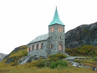
King Oscar II Chapel is a parish church of the Church of Norway in Sør-Varanger Municipality in Finnmark county, Norway. It is located near the village of Grense Jakobselv, about 500 metres (1,600 ft) from the border with Russia. It is one of the churches for the Sør-Varanger parish which is part of the Varanger prosti (deanery) in the Diocese of Nord-Hålogaland. The stone church was built in a long church style in 1869 by the architect Jacob Wilhelm Nordan (1824–1892). The church seats about 72 people.
Jarfjorden is a fjord on Varanger Fjord in Sør-Varanger Municipality in Finnmark county, Norway. The fjord stretches 21 kilometres (13 mi) south to Jarfjordbotn.

Polmak is a former municipality in Finnmark county, Norway. The 2,257.5-square-kilometre (871.6 sq mi) municipality existed from 1903 until its dissolution in 1964. The area is now part of Tana Municipality. The administrative centre was the village of Polmak where Polmak Church is located.
