
Birkeland is the administrative centre of the municipality of Birkenes in Aust-Agder county, Norway. The village is located on the eastern shore of the river Tovdalselva, across the river from the village of Flakk. The Norwegian National Road 41 runs through the village. The village is located about 30 kilometres (19 mi) northeast of the city of Kristiansand and about 14 kilometres (8.7 mi) northwest of Lillesand.

Topsæ is a lake in the municipality of Bygland in Aust-Agder county, Norway. The 2.4-square-kilometre (0.93 sq mi) lake is located 3 kilometres (1.9 mi) east of the lake Hovatn, about 10 kilometres (6.2 mi) northeast of the village of Åraksbø. The Topsæfossen waterfall is located at the north end of the lake at the primary inflow. At the southeastern corner of the lake, there is a small dam to regulate the outflow of the lake into the Tovdalselva watershed.
Øyarvatnet or Øyarvatn is a lake in Norway. It sits on the border between the municipalities of Valle in Aust-Agder county and Sirdal in Vest-Agder county, about 30 kilometres (19 mi) northeast of the village of Lunde, Sirdal and about 32 kilometres (20 mi) west of Austad in Bygland. The lake is part of the Kvina river system. It is located just to the south of the lake Rosskreppfjorden, which flows into it. The dam at the south end of the 8.05-square-kilometre (3.11 sq mi) lake keeps it at an elevation of 837 metres (2,746 ft).
Østre Grimevann or Austre Grimevannet is a lake in the municipality of Lillesand in Aust-Agder county, Norway. The 3.94-square-kilometre (1.52 sq mi) lake is located north of the European route E18 highway about 3 kilometres (1.9 mi) from the city of Lillesand. It is the drinking water reservoir for the municipality of Lillesand.
Longerakvatnet or Longeraksvatnet is a lake in the municipality of Bygland in Aust-Agder county, Norway. It has a small dam on the southwest side to regulate the water level for hydro-electric power generation at a plant located down the hill. The lake discharges into the Longeraksåni river which flows into the Byglandsfjorden near the village of Longerak. The 3.4-square-kilometre (1.3 sq mi) lake is located about 6 kilometres (3.7 mi) southeast of the village of Lauvdal and about 10 kilometres (6.2 mi) northeast of the village of Byglandsfjord.
Kolsvatnet is a lake in the municipality of Valle in Aust-Agder county, Norway. It is located about 14 kilometres (8.7 mi) southwest of the village of Valle and about 15 kilometres (9.3 mi) northwest of the village of Rysstad. The lake is located south of the lake Botnsvatnet, east of the mountain Urddalsknuten, and northeast of the lake Rosskreppfjorden. The lake has an area of 2.72 square kilometres (1.05 sq mi) and sits at an elevation of 1,034 metres (3,392 ft) above sea level.
Holmavatnet is a lake the Setesdalsheiene mountains of Southern Norway. It is located on the border of the municipalities of Suldal, Vinje, and a small part in Bykle. The southeastern corner of the lake is in Bykle, and it is the northernmost part of all of Aust-Agder county. The lake Skyvatn is located about 5 kilometres (3.1 mi) to the south of the lake.
Høvringsvatnet or Høvringsvatn is a lake in the municipality of Evje og Hornnes in Aust-Agder county, Norway. It's located about 10 kilometres (6.2 mi) northeast of the village area of Evje and about 6 kilometres (3.7 mi) southeast of the village area of Byglandsfjord. The lake Homstølvatnet in Froland municipality is located about 5 kilometres (3.1 mi) to the northeast.
Ytre Storevatnet is a lake in the municipality of Bykle in Aust-Agder county, Norway. The 2.8-square-kilometre (1.1 sq mi) lake makes up the northernmost part of the Svartevatnet reservoir that empties into the Sira River system. The lake is located just south of the lake Blåsjø and southwest of Botsvatn. The village of Bykle is about 25 kilometres (16 mi) northeast of the lake.

Høvåg is former municipality in Aust-Agder county, Norway. The 77-square-kilometre (30 sq mi) municipality existed from 1865 until its dissolution in 1962. It was located in the southern part of the present-day municipality of Lillesand. The administrative centre of the municipality was the village of Høvåg where the Høvåg Church is located. Old coastal settlements in Høvåg include Ulvøysund, Gamle Hellesund, Skottevik, Kjøbmannsvig and Åkerøyhamn. The village of Høvåg is located midway between the towns of Lillesand and Kristiansand.
Helldal is a village in Lillesand municipality in Aust-Agder county, Norway. The village is located along the Norwegian County Road 420 and the Kaldvellfjorden, about 3 kilometres (1.9 mi) northeast of the town of Lillesand. Access to the European route E18 highway is just south of Helldal.
Ribe is a village in Lillesand municipality in Aust-Agder county, Norway. The village is located on the east side of the Kvåsefjorden, about 2 kilometres (1.2 mi) north of the village of Ulvøysund and about 5 kilometres (3.1 mi) south of the village of Høvåg. The Skottevik area lies about 2 kilometres (1.2 mi) east of Ribe.

Trøe is a village in Lillesand municipality in Aust-Agder county, Norway. The village is located along the Norwegian County Road 420 about 5 kilometres (3.1 mi) north of the village of Høvåg and about 10 kilometres (6.2 mi) southwest of the town of Lillesand. The village sits along the head of a bay that flows north from the Blindleia inland waterway.
Tveide is a village in Birkenes municipality in Aust-Agder county, Norway. The village is located about 3 kilometres (1.9 mi) south of the municipal centre of Birkeland. Historically, there was a railway station here along the now-closed Lillesand-Flaksvand Line.

Ulvøysund is a village and an outport in the municipality of Lillesand in Aust-Agder county, Norway. The village lies on the east side of the Kvåsefjorden on the island of Ulvøya. Just northeast of Ulvøysund is the entrance to the Blindleia inland waterway which leads towards the town of Lillesand. The village is connected to the mainland by road. The nearby village of Ribe lies about 2 kilometres (1.2 mi) straight north of Ulvøysund. The village was historically used as an outport along the Skaggerak coast for the large ships that couldn't navigate inland through the archipelago to the towns on the mainland.
Vesterhus is a village in Lillesand municipality in Aust-Agder county, Norway. The village is located at the innermost part of the Kvåsefjorden, about 4 kilometres (2.5 mi) southwest of the village of Høvåg and about 10 kilometres (6.2 mi) east of the city of Kristiansand.
Åkerøyhamn is a village in Lillesand municipality in Aust-Agder county, Norway. The village is located on the small island of Ågerøya, about 2 kilometres (1.2 mi) southwest of the village of Brekkestø. Åkerøyhamn is only accessible by boat, with the Blindleia strait separating it from the mainland.
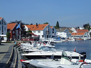
Lillesand is the administrative centre of Lillesand municipality in Aust-Agder county, Norway. The town is located along the Skaggerak coast, about 18 kilometres (11 mi) southwest of the town of Grimstad and about 25 kilometres (16 mi) northeast of the city of Kristiansand. The 5.03-square-kilometre (1,240-acre) town has a population (2016) of 7,530 which gives the town a population density of 1,497 inhabitants per square kilometre (3,880/sq mi).

Høvåg is a village in Lillesand municipality in Aust-Agder county, Norway. The village is located about 12 kilometres (7.5 mi) southwest of the town of Lillesand and about 15 kilometres (9.3 mi) northeast of the city of Kristiansand. The village lies on the northern shore of the Kjerkekilen, a strait leading from the Blindleia to the Isefjorden. The village is the site of Høvåg Church and from 1865 until 1962, it was the administrative centre of the old municipality of Høvåg.


