Vanylven is a municipality in Møre og Romsdal county, Norway. It is part of the Sunnmøre region. The administrative centre is the village of Fiskåbygd. Other villages in the municipality include Sandnes, Åheim, Åram, Rovdane, Eidså, Slagnes, and Myklebost.

Sande is a municipality in Møre og Romsdal county, Norway. It is part of the Sunnmøre region. The administrative centre is the village of Larsnes on the island of Gurskøya. Other villages in Sande include Gursken, Sandshamn, Bringsinghaug, and Voksa.
Ørsta (help·info) is a municipality in Møre og Romsdal county, Norway. It is part of the Sunnmøre region of Western Norway. The administrative centre of the municipality is the village of Ørsta. Other villages in the municipality include Hovdebygda, Flåskjer, Leira, Liadal, Urke, Bjørke, Barstadvik, Åmdalen, Follestaddalen, Nordre Vartdal, Vartdal, Sæbø, Sætre, Store-Standal, and Ytre Standal.

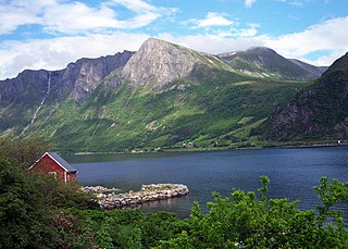
Myklebost or Syvde is a village in Vanylven Municipality in Møre og Romsdal county, Norway. The village is located at the end of the Syvdsfjorden about 12 kilometres (7.5 mi) east of the municipal center of Fiskåbygd and 16 kilometres (9.9 mi) south of the village of Rovdane. The 0.76-square-kilometre (190-acre) village has a population (2012) of 393, giving the village a population density of 517 inhabitants per square kilometre (1,340/sq mi).
Fiskåbygd or Fiskå is a coastal village that is also the administrative centre of Vanylven Municipality in Møre og Romsdal county, Norway. The village is located about 100 kilometres (62 mi) southwest of the city of Ålesund, about 12 kilometres (7.5 mi) east of the village of Myklebost, and about 30 kilometres (19 mi) southwest of the village of Rovdane. Fiskåbygd lies along the shores of the Vanylvsfjorden, east of the Stadlandet peninsula in Selje Municipality.

Langvatnet (Norwegian) or Tjoaddnejávrre (Lule Sami) is a lake that lies on the border between Norway and Sweden. Almost all of the lake is located in Tysfjord Municipality in Nordland county, Norway with a very small part of the lake in Jokkmokk Municipality in Norrbotten County, Sweden. The 5.46-square-kilometre (2.11 sq mi) lake is located about 20 kilometres (12 mi) southeast of the village of Kjøpsvik in Tysfjord.

Byavatnet is a lake in the municipality of Levanger in Trøndelag county, Norway. It is located about 2.5 kilometres (1.6 mi) south of the village of Ekne and about 3 kilometres (1.9 mi) west of the village of Ronglan. The lake Hammervatnet lies about 3.5 kilometres (2.2 mi) south of Byavatnet and the lake Sønningen lies about 1.5 kilometres (0.93 mi) to the northwest. The 2.31-square-kilometre (570-acre) lake is about 5 kilometres (3.1 mi) long and about 800 metres (0.5 mi) wide.
Gilten is a lake in the municipality of Steinkjer in Trøndelag county, Norway. The 31.62-square-kilometre (12.21 sq mi) lake lies in the northern part of Steinkjer, about 8 kilometres (5.0 mi) northeast of the village of Kvam, about 1.5 kilometres (0.93 mi) north of the village of Følling, and about 14 kilometres (8.7 mi) east of the village of Namdalseid. The lake is only accessible by road from Namdalseid, even though most of the 31.62-square-kilometre (12.21 sq mi) lake lies in Steinkjer. The lake Bangsjøan lies to the northeast and the lake Snåsavatnet lies to the south.

Gravatnet is a lake in the municipality of Sirdal in Vest-Agder county, Norway. The 5.33-square-kilometre (2.06 sq mi) lake is located about 9 kilometres (5.6 mi) north of the small village of Lunde. The lake lies immediately south of the lake Valevatn, which flows out into Gravatnet. The water in Gravatnet is stopped by a dam on the south side. The water is regulated at an elevation of 660 metres (2,170 ft) and it flows out through the small river Gravassåni which is a tributary of the big river Sira.

Dingevatn or Dingevatnet is the 18th deepest lake in Norway, reaching a maximum depth of 220 metres (720 ft). It is located in the municipality of Gulen in Sogn og Fjordane county. The 2.84-square-kilometre (1.10 sq mi) lake is located just east of the village of Dingja, about 1 kilometre (0.62 mi) southeast of the mouth of the Sognefjorden. The lake lies about 4 kilometres (2.5 mi) north of the municipal center of Eivindvik. The lake flows out into the small Dingjaelva river, which runs past the village of Dingja before emptying into the Sognesjøen strait.
Rovdane is a village in Vanylven Municipality in Møre og Romsdal county, Norway. It is located along the Rovdefjorden, about 15 kilometres (9.3 mi) north of the village of Myklebost, 27 kilometres (17 mi) northeast of the municipal center of Fiskåbygd, and 20 kilometres (12 mi) west of the village of Volda. The district around Rovdane is referred to as Rovdestranda. Rovde Church is located in Rovdane.
Syvde is a former municipality in Møre og Romsdal county, Norway. The municipality included the areas surrounding the Syvdsfjorden in the eastern part of the present-day Vanylven Municipality. The 125-square-kilometre (48 sq mi) municipality existed from 1918 until 1964. The administrative centre of the municipality was the village of Myklebost, at the end of the fjord. Syvde Church was the municipal church.
Kvamsøya is an island in the municipality of Sande in Møre og Romsdal county, Norway. It is located 6 kilometres (3.7 mi) east of the Stad peninsula in Selje Municipality and about 7 kilometres (4.3 mi) west of the village of Larsnes on the island of Gurskøya. The island lies in the Vanylvsgapet, the entrance to the Vanylvsfjorden.

Vanylven Church is a parish church in Vanylven Municipality in Møre og Romsdal county, Norway. It is located in the village of Slagnes, on the shore of the Vanylvsfjorden. The church is part of the Vanylven parish in the Søre Sunnmøre deanery in the Diocese of Møre. The white brick church was built in 1864 by the architect Georg Andreas Bull. The church seats about 320 people.
Rovdefjorden is a fjord in Møre og Romsdal county, Norway. The fjord runs through the municipalities of Sande, Herøy, Vanylven, Volda, Ørsta, and a tiny part of Ulstein. The eastern end of the fjord connects with the Vartdalsfjorden and Voldsfjorden and the western end of the fjord connects with the Hallefjorden. The Syvdsfjorden branches off the Rovdefjorden to the south. The fjord is bounded by the mainland to the south and the island of Gurskøya to the north.
Voksa is an island in Sande Municipality in Møre og Romsdal county, Norway. The 1.3-square-kilometre (0.50 sq mi) island lies about 2 kilometres (1.2 mi) east of the island of Kvamsøya, about 1.5 kilometres (0.93 mi) south of the island of Sandsøya, about 3.3 kilometres (2.1 mi) west of the larger island of Gurskøya, and about 1.5 kilometres (0.93 mi) north of the mainland village of Åram in neighboring Vanylven Municipality.

Saint Jetmund Church is a former parish church in Vanylven Municipality in Møre og Romsdal county, Norway. The marble and stone church was built in 1150 and torn down in 1864 when it was replaced by the newly built Vanylven Church in nearby Slagnes. St. Jetmund Church was located in the village of Åheim, along the inner part of the Vanylvsfjorden.
Syvdsfjorden is a fjord in Vanylven Municipality in Møre og Romsdal county, Norway. The 10-kilometre (6.2 mi) long fjord flows from the village of Myklebost to the north until it empties into the Rovdefjorden. The old Syvde municipality was centered on this fjord until it was merged into Vanylven municipality in 1964. The sides of the fjord are mountainous, particularly the eastern side, with mountainsides stretching up to 800 metres (2,600 ft) high coming right out of the water.
Åram is a village in Vanylven Municipality in Møre og Romsdal county, Norway. The village is located on the mainland, about 12 kilometres (7.5 mi) straight north of the municipal centre of Fiskåbygd. The village has a ferry quay with regular connections to the nearby islands of Kvamsøya, Voksa, and Gurskøya. Åram Church is located in the village.


