See also
| This disambiguation page lists articles associated with the title Sleaford, South Australia. If an internal link led you here, you may wish to change the link to point directly to the intended article. |
Sleaford, South Australia is a locality.
Sleaford, South Australia may also refer to.
| This disambiguation page lists articles associated with the title Sleaford, South Australia. If an internal link led you here, you may wish to change the link to point directly to the intended article. |

Lincoln National Park is a protected area in the Australian state of South Australia located about 249 kilometres (155 mi) west of the state capital of Adelaide and about 9.5 kilometres (5.9 mi) south of the municipal seat of Port Lincoln. It consists of a mainland area on the Jussieu Peninsula on the south eastern tip of Eyre Peninsula and a number of nearby islands. The national park contains significant sites of natural, indigenous and early European heritage.
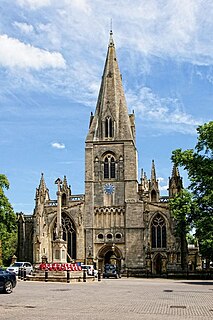
Sleaford is a market town and civil parish in Lincolnshire, England. Since 1973, the parish boundaries have included Quarrington to the south-west, Holdingham to the north and Old Sleaford to the east – contiguous settlements and former civil parishes which, with New Sleaford, had formed an Urban District. The town is on the edge of the fertile Fenlands, about 11 miles north-east of Grantham, 16 mi (26 km) west of Boston, and 17 mi (27 km) south of Lincoln. With a population of 17,671 at the 2011 Census, the town is the largest settlement in the North Kesteven district. Bypassed by the A17 and the A15, it is connected to Lincoln, Newark, Peterborough and King's Lynn. Sleaford railway station is on the Nottingham to Skegness and Peterborough to Lincoln Lines.

North Kesteven is a local government district in the East Midlands. Just over 100 miles (160 km) north of London, it is east of Nottingham and south of Lincoln. North Kesteven is one of seven districts in Lincolnshire, England and is in the centre of the County. Its council, North Kesteven District Council, is based in Sleaford in the former offices of Kesteven County Council.
Playhouse is a common term for a theatre. Specifically it may refer to:

The Eyre Peninsula is a triangular peninsula in South Australia. It is bounded on the east by Spencer Gulf, the west by the Great Australian Bight, and the north by the Gawler Ranges.
Tournefort may refer to:

Sleaford and North Hykeham is a parliamentary constituency in Lincolnshire, England which elects a single Member of Parliament (MP) to the House of Commons of the UK Parliament. It has been represented since 2016 by Dr Caroline Johnson, who is a member of the Conservative Party. The seat was created in 1997 and has always been represented by Members of Parliament (MPs) from the Conservative Party; like all British constituencies, it elects one candidate by the first-past-the-post voting system. Johnson became the MP for the constituency after a by-election in December 2016, following the resignation of the previous MP for the seat, Stephen Phillips. The constituency is considered a safe seat for the Conservatives.

The District Council of Lower Eyre Peninsula is a local government area located on Eyre Peninsula in South Australia. The district covers the southern tip of the peninsula, except for the small area taken up by the City of Port Lincoln.
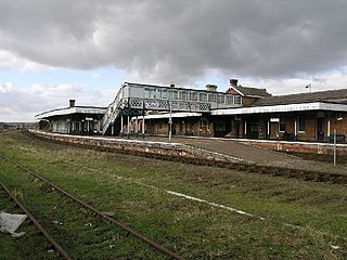
Sleaford railway station serves the town of Sleaford in Lincolnshire, England. The station is 21.25 miles (34 km) south of Lincoln Central.

The County of Flinders is one of the 49 cadastral counties of South Australia. The county covers the southern part of the Eyre Peninsula “bounded on the north by a line connecting Point Drummond with Cape Burr, and on all other sides by the seacoast, including all islands adjacent to the main land.”
Branston and Mere is a civil parish in the North Kesteven district of Lincolnshire, England. It is situated some 4 miles (6 km) roughly south-east from the city and county town of Lincoln. The parish is a long strip between the RAF Waddington airfield and the River Witham near Bardney. The A15 road crosses the extreme west and the parish is bisected by the Sleaford to Lincoln railway line The civil parish was created in 1931, by merging the two former parishes of Branston and Mere.
Jussieu Peninsula is a peninsula located at the south east end of Eyre Peninsula in South Australia. It is bounded by Proper Bay and Spalding Cove within the natural harbour known as Port Lincoln to the north, Spencer Gulf to the east and the Great Australian Bight to the south. While it was first explored and mapped by Matthew Flinders during February 1802, Flinders did not name it. In 1913, the name proposed by François Péron and Louis de Freycinet from Baudin's expedition when it visited later in 1802 was declared as the peninsula's official name by the Government of South Australia. Jussieu refers to the French botanist, Antoine Laurent de Jussieu. While parts of its surface have been cleared and used for agricultural purposes in the past, it is currently occupied by two protected areas: the Lincoln National Park and the Memory Cove Wilderness Protection Area.
Mikkira Station is a pastoral lease that operates as a sheep station in South Australia.
Sleaford Mere Conservation Park, formerly the Sleaford Mere National Park, is a protected area in the Australian state of South Australia located in the locality of Sleaford on the Jussieu Peninsula at the south eastern tip of Eyre Peninsula about 15 kilometres (9.3 mi) south west of Port Lincoln.

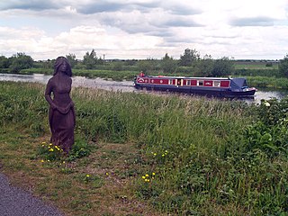
Sleaford Mere is a permanent saline lake, located on the Jussieu Peninsula on the south eastern tip of Eyre Peninsula in South Australia about 15 kilometres south west of Port Lincoln. The lake was given its modern name by the British explorer, Matthew Flinders, on 26 February 1802. Since 1969, the lake has been part of the Sleaford Mere Conservation Park and since 2005, it has been listed as a nationally important wetland. The lake and its environs are notable as a venue for recreational pursuits such as canoeing.

Cape Carnot is a headland in the Australian state of South Australia located on the west side of the southern tip of Eyre Peninsula about 30 kilometres south west of the city of Port Lincoln. The Eyre Peninsula has a double tip; the other tip, 3 nautical miles to the east, is Cape Wiles. Cape Carnot is one of a number of coastal features first discovered but not subsequently named by Matthew Flinders in February 1802 and which remained unnamed. In 1913, the Government of South Australia gave the unnamed feature the name proposed by the Baudin expedition when it visited in April 1802. The name Cape Carnot honours Lazare Carnot who is notable as a "French mathematician, general and statesman, who played a prominent part in the French Revolution and the Napoleonic era".
Cape Wiles is a headland located on the west side of the southern tip of Eyre Peninsula in South Australia about 27 kilometres south west of the city of Port Lincoln. The cape is described by one source as being the south east extremity of “a broad promontory” of which Cape Carnot is the south west extremity at a distance of 3 nautical miles to the west. The cape also is the western extremity of Sleaford Bay.

Sleaford is a locality in the Australian state of South Australia located at the southern tip of the Eyre Peninsula overlooking the Great Australian Bight about 260 kilometres west of the state capital of Adelaide and about 17 kilometres west of the municipal seat of Port Lincoln.
Fishery Bay whaling station was a whaling station located in the Colony of South Australia on the coast of Fishery Bay, a subsidiary of the larger Sleaford Bay, on Eyre Peninsula about 32 kilometres (20 mi) south-west of Port Lincoln. It operated in the 1830s and 1840s and helped to provide the colony with one of its first export commodities.

Sleaford Bay is a bay located in the Australian state of South Australia on the southern coast of Eyre Peninsula. It was named by the British navigator, Matthew Flinders in 1802.