
Lincoln National Park is a protected area in the Australian state of South Australia located about 249 kilometres (155 mi) west of the state capital of Adelaide and about 9.5 kilometres (5.9 mi) south of the municipal seat of Port Lincoln. It consists of a mainland area on the Jussieu Peninsula on the south eastern tip of Eyre Peninsula and a number of nearby islands. The national park contains significant sites of natural, indigenous and early European heritage.

The District Council of Lower Eyre Peninsula is a local government area located on Eyre Peninsula in South Australia. The district covers the southern tip of the peninsula, except for the small area taken up by the City of Port Lincoln.
Coffin Bay, originally Coffin's Bay, is a town at the southern extremity of the Eyre Peninsula, a wheat growing area of South Australia. At the 2016 census, Coffin Bay had a population of 611.

The City of Whyalla is a local government area in South Australia, located at the north-east corner of the Eyre Peninsula. It was established in 1970, replacing the town commission, which had been running the town previously. The district is mostly industrial, with many large companies having factories in the city.

The County of Flinders is one of the 49 cadastral counties of South Australia. The county covers the southern part of the Eyre Peninsula “bounded on the north by a line connecting Point Drummond with Cape Burr, and on all other sides by the seacoast, including all islands adjacent to the main land.”
Koppio is a locality in the Australian state of South Australia located on the Eyre Peninsula about 256 kilometres (159 mi) west of the state capital of Adelaide and about 32 kilometres (20 mi) north of Port Lincoln, and within the Tod River catchment area. While long-established agricultural activities dominate the region is also prospective for graphite and iron ore. The Koppio Smithy Museum is a local tourist attraction replete with buildings and artifacts representing the early pioneer heritage of Eyre Peninsula.
Jussieu Peninsula is a peninsula located at the south east end of Eyre Peninsula in South Australia. It is bounded by Proper Bay and Spalding Cove within the natural harbour known as Port Lincoln to the north, Spencer Gulf to the east and the Great Australian Bight to the south. While it was first explored and mapped by Matthew Flinders during February 1802, Flinders did not name it. In 1913, the name proposed by François Péron and Louis de Freycinet from Baudin's expedition when it visited later in 1802 was declared as the peninsula's official name by the Government of South Australia. Jussieu refers to the French botanist, Antoine Laurent de Jussieu. While parts of its surface have been cleared and used for agricultural purposes in the past, it is currently occupied by two protected areas: the Lincoln National Park and the Memory Cove Wilderness Protection Area.
Sleaford Mere Conservation Park, formerly the Sleaford Mere National Park, is a protected area in the Australian state of South Australia located in the locality of Sleaford on the Jussieu Peninsula at the south eastern tip of Eyre Peninsula about 15 kilometres (9.3 mi) south west of Port Lincoln.
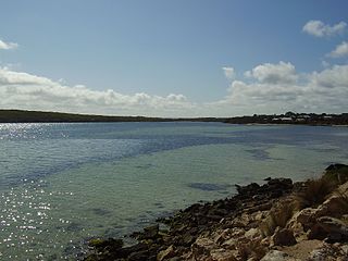
Sleaford Mere is a permanent saline lake, located on the Jussieu Peninsula on the south eastern tip of Eyre Peninsula in South Australia about 15 kilometres south west of Port Lincoln. The lake was given its modern name by the British explorer, Matthew Flinders, on 26 February 1802. Since 1969, the lake has been part of the Sleaford Mere Conservation Park and since 2005, it has been listed as a nationally important wetland. The lake and its environs are notable as a venue for recreational pursuits such as canoeing.
Mullaquana is a suburb in the Australian state of South Australia located immediately adjoining the southern side of the city of Whyalla in the north east corner of Eyre Peninsula. The locality is bounded by Lincoln Highway to its northern side, the suburb of Whyalla to the east and by and the Spencer Gulf coastline to the south east.
Lincoln National Park is a locality located on the Jussieu Peninsula at the southern tip of the Eyre Peninsula in the Australian state of South Australia about 250 kilometres west of the state capital of Adelaide and about 13 kilometres south of the city of Port Lincoln.
Tulka is a locality in the Australian state of South Australia located on the southern tip of Eyre Peninsula overlooking the western end of the body of water known as Port Lincoln and which is located 259 kilometres west of the state capital of Adelaide and about 10 kilometres west of the city of Port Lincoln.
Pureba is a locality in the Australian state of South Australia located on the west coast of Eyre Peninsula and on land to the immediate north of the peninsula about 528 kilometres north-west of the state capital of Adelaide and about 52 kilometres north-east and 90 kilometres north respectively of the municipal seats of Ceduna and Streaky Bay.
Uley is a locality in the Australian state of South Australia located at the southern tip of the Eyre Peninsula overlooking the body of water known as the Great Australian Bight about 273 kilometres (170 mi) west of the state capital of Adelaide and about 22 kilometres (14 mi) west of the city of Port Lincoln.
Farm Beach is a locality in the Australian state of South Australia located on the Eyre Peninsula in the state’s west overlooking the body of water known as Coffin Bay about 297 kilometres (185 mi) west of the state capital of Adelaide and about 40 kilometres (25 mi) south-west of the municipal seat of Cummins.
Little Douglas is a locality in the Australian state of South Australia located on the Eyre Peninsula in the state’s west overlooking the body of water known as Coffin Bay about 293 kilometres (182 mi) west of the state capital of Adelaide and about 42 kilometres (26 mi) south-west of the municipal seat of Cummins.
Kellidie Bay is a locality in the Australian state of South Australia located on the Eyre Peninsula in the state’s west overlooking parts of the body of water known as Coffin Bay about 290 kilometres (180 mi) west of the state capital of Adelaide and about 42 kilometres (26 mi) south-west of the municipal seat of Cummins.
Duck Ponds is a locality in the Australian state of South Australia located on the Eyre Peninsula in the state's west about 258 kilometres (160 mi) west of the state capital of Adelaide, about 51 kilometres (32 mi) south of the municipal seat of Cummins and about 6 kilometres (3.7 mi) west of the city of Port Lincoln.

Sleaford Bay is a bay located in the Australian state of South Australia on the southern coast of Eyre Peninsula. It was named by the British navigator, Matthew Flinders in 1802.
Brooker is a locality in the Australian state of South Australia located in the state’s west on Eyre Peninsula about 266 kilometres (165 mi) west of the state capital of Adelaide and about 38 kilometres (24 mi) north-west of the municipal seat in Tumby Bay.

