
Lincoln National Park is a protected area in the Australian state of South Australia located about 249 kilometres (155 mi) west of the state capital of Adelaide and about 9.5 kilometres (5.9 mi) south of the municipal seat of Port Lincoln. It consists of a mainland area on the Jussieu Peninsula on the south eastern tip of Eyre Peninsula and a number of nearby islands. The national park contains significant sites of natural, indigenous and early European heritage.

The District Council of Lower Eyre Peninsula is a local government area located on Eyre Peninsula in South Australia. The district covers the southern tip of the peninsula, except for the small area taken up by the City of Port Lincoln.

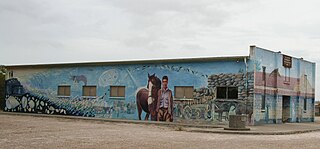
Elliston is a small coastal town in the Australian state of South Australia on the west coast of Eyre Peninsula 169 km northwest of Port Lincoln and 641 km west of Adelaide. The township is located on Waterloo Bay. At the 2006 census, Elliston had a population of 377.
Coffin Bay, originally Coffin's Bay, is a town at the southern extremity of the Eyre Peninsula, a wheat growing area of South Australia. At the 2016 census, Coffin Bay had a population of 611.

Streaky Bay is a coastal town on the western side of the Eyre Peninsula, in South Australia just off the Flinders Highway, 303 km (188 mi) north-west of Port Lincoln and 727 km (452 mi) by road from Adelaide. At the 2016 census, Streaky Bay recorded a population of 1, 378.

Wangary is a town on the Eyre Peninsula in South Australia, located 45 kilometres (28 mi) west of Port Lincoln on the Flinders Highway near Coffin Bay.

Nullarbor is a locality in the Australian state of South Australia located 295 kilometres (183 mi) to the west of the town of Ceduna in the western part of the state immediately adjoining the border with Western Australia.

Karkoo is a small rural centre located 20 km to the north of Cummins in the centre of Eyre Peninsula, South Australia. It is located in an agricultural district where the main economic activities are cereal growing and sheep grazing, and most of the district's small population live on surrounding farms.

Penong is a town and locality on the Nullarbor Plain, in the far west of the state of South Australia located about 616 kilometres (383 mi) north-west of the state capital of Adelaide. With no settlements between it and Border Village on the border with Western Australia, 400 km (250 mi) away on the Eyre Highway, it is a popular rest-stop for travellers.
Booborowie is a locality in South Australia. It is located 200 km (124 mi) north of Adelaide. At the 2016 census, the Booborowie district had a population of 218.
Boston is a locality on the Eyre Peninsula of South Australia, situated in the District Council of Lower Eyre Peninsula. It consists of a coastal section immediately north of Port Lincoln and a broader area inland; while it is residential along the coast, much of the locality remains semi-rural. The name and boundaries were formalised in October 2003 for the long established local name. On 15 October 2009, sections of Boston were severed and added to North Shields and the new locality of Tiatukia, while a portion of adjacent Hawson was added to Boston.

Bungaree is a locality in the Mid North of South Australia, situated north of Clare, along the Main North Road.
Sheringa is a coastal locality on the western side of Eyre Peninsula in South Australia on the Great Australian Bight.

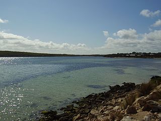
Mount Dutton Bay is a coastal locality in the Eyre and Western region of South Australia, situated in the District Council of Lower Eyre Peninsula. The name and boundaries were formalised in October 2003 in respect of the long established local name which is derived from the body of water known as Mount Dutton Bay. The locality incorporates three older residential "shack sites": Mount Dutton Bay West, on Dolphin Drive, Mount Dutton Bay East, on Woolshed Drive, and Shelley Beach/Salt Creek, on Shelly Beach Road. It is part of the cadastral Hundred of Lake Wangary.
Point Boston is a locality in the Eyre and Western Region of South Australia, situated within the District Council of Lower Eyre Peninsula. It was formally established on 15 October 2009, when it was separated from North Shields; it is named after the geographical feature, which was named by Matthew Flinders in 1802.

Lincoln National Park is a locality located on the Jussieu Peninsula at the southern tip of the Eyre Peninsula in the Australian state of South Australia about 250 kilometres west of the state capital of Adelaide and about 13 kilometres south of the city of Port Lincoln.

Flinders Ranges is a locality in the Australian state of South Australia located in the mountain range of the same name, about 380 km (240 mi) north of the state capital of Adelaide, about 86 km (53 mi) north-east of the municipal seat of Quorn and about 131 km (81 mi) north-east of the centre of Port Augusta in the state's Far North region.
The County of Musgrave is a cadastral unit in the Australian state of South Australia that covers land on the west coast of Eyre Peninsula. It was proclaimed on 22 June 1876 and named after Anthony Musgrave, the Governor of South Australia from 9 June 1876 to 29 January 1877.
The Hundred of Lake Wangary is a hundred within County of Flinders, South Australia. It is at the southern end of the Eyre Peninsula in South Australia, located 45 kilometres (28 mi) west of Port Lincoln. It is named after the freshwater Lake Wangary.
Duck Ponds is a locality in the Australian state of South Australia located on the Eyre Peninsula in the state's west about 258 kilometres (160 mi) west of the state capital of Adelaide, about 51 kilometres (32 mi) south of the municipal seat of Cummins and about 6 kilometres (3.7 mi) west of the city of Port Lincoln.

