
Port Lincoln Prison is an Australian prison on the Eyre Peninsula located in Duck Ponds, South Australia about 257 kilometres (160 mi) west of the state capital of Adelaide and about 6 kilometres (3.7 mi) north-west of the regional city of Port Lincoln. It was opened in 1966.

The District Council of Lower Eyre Peninsula is a local government area located on Eyre Peninsula in South Australia. The district covers the southern tip of the peninsula, except for the small area taken up by the City of Port Lincoln.

Wangary is a town on the Eyre Peninsula in South Australia, located 45 kilometres (28 mi) west of Port Lincoln on the Flinders Highway near Coffin Bay.
The Tumby Bay District Council is a local government area of South Australia covering an area of the North Eastern Eyre Peninsula. It was established in 1906, only six years after the town of Tumby Bay was established, when the district was severed from the former District Council of Lincoln to form the present council.
Ungarra is a small agricultural based town located on the Eyre Peninsula, in the Australian state of South Australia about 248 kilometres (154 mi) from the state's capital, Adelaide and around 80 kilometres (50 mi) north of Port Lincoln. At the 2006 census, Ungarra had a population of 241.

Karkoo is a small rural centre located 20 km to the north of Cummins in the centre of Eyre Peninsula, South Australia. It is located in an agricultural district where the main economic activities are cereal growing and sheep grazing, and most of the district's small population live on surrounding farms.

Kangarilla is a town near Adelaide, South Australia. It lies within the City of Onkaparinga and has postcode 5157. At the 2016 census, Kangarilla had a population of 896.
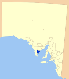
Boston is a locality on the Eyre Peninsula of South Australia, situated in the District Council of Lower Eyre Peninsula. It consists of a coastal section immediately north of Port Lincoln and a broader area inland; while it is residential along the coast, much of the locality remains semi-rural. The name and boundaries were formalised in October 2003 for the long established local name. On 15 October 2009, sections of Boston were severed and added to North Shields and the new locality of Tiatukia, while a portion of adjacent Hawson was added to Boston.
Kielpa is a town and locality on Eyre Peninsula in South Australia. It is midway between Rudall and Darke Peak on the Eyre Peninsula Railway.
Rudall is a town and locality in South Australia. At the 2016 census, Rudall had a population of 90. It is named for the cadastral Hundred of Rudall, which was named after politician Samuel Rudall.

The County of Flinders is one of the 49 cadastral counties of South Australia. The county covers the southern part of the Eyre Peninsula “bounded on the north by a line connecting Point Drummond with Cape Burr, and on all other sides by the seacoast, including all islands adjacent to the main land.”
Koppio is a locality in the Australian state of South Australia located on the Eyre Peninsula about 256 kilometres (159 mi) west of the state capital of Adelaide and about 32 kilometres (20 mi) north of Port Lincoln, and within the Tod River catchment area. While long-established agricultural activities dominate the region is also prospective for graphite and iron ore. The Koppio Smithy Museum is a local tourist attraction replete with buildings and artifacts representing the early pioneer heritage of Eyre Peninsula.
Mount Hope is a small town on the Flinders Highway on the west coast of Eyre Peninsula in South Australia. It was the terminus of a branch of the Eyre Peninsula Railway from Yeelanna from 1914 until but the line was closed and dismantled in 1966. The town was surveyed in 1916, and proposed to be named Mount Woakwine, but no action was taken to call it that.
Mortana is a rural locality in South Australia, located on the Eyre Peninsula. It is traversed by the Flinders Highway. The boundaries for the locality were established in April 2001 in respect of the long established local name.

Mount Dutton Bay is a coastal locality in the Eyre and Western region of South Australia, situated in the District Council of Lower Eyre Peninsula. The name and boundaries were formalised in October 2003 in respect of the long established local name which is derived from the body of water known as Mount Dutton Bay. The locality incorporates three older residential "shack sites": Mount Dutton Bay West, on Dolphin Drive, Mount Dutton Bay East, on Woolshed Drive, and Shelley Beach/Salt Creek, on Shelly Beach Road. It is part of the cadastral Hundred of Lake Wangary.
Point Boston is a locality in the Eyre and Western Region of South Australia, situated within the District Council of Lower Eyre Peninsula. It was formally established on 15 October 2009, when it was separated from North Shields; it is named after the geographical feature, which was named by Matthew Flinders in 1802.

Kiana is a coastal locality on the Eyre Peninsula of South Australia, situated within the District Council of Lower Eyre Peninsula. The modern boundaries were formally established in October 2003, with it being named after the cadastral Hundred of Kiana. The modern locality only covers the northern half of the hundred; the southern half is the locality of Mount Hope. The hundred itself was given an Aboriginal name by Governor William Jervois in 1879.
Verran is a locality in the Australian state of South Australia located on the Eyre Peninsula about 241 kilometres west of the state capital of Adelaide. Its name is derived from the cadastral unit of the Hundred of Verran, which was named for former Premier John Verran.

Tucknott Scrub Conservation Park is a protected area located in the Australian state of South Australia on the Eyre Peninsula in the gazetted locality of Whites Flat about 12 kilometres north-east of the town centre in Wanilla and about 30 kilometres north of the municipal seat of Port Lincoln.
Duck Ponds is a locality in the Australian state of South Australia located on the Eyre Peninsula in the state's west about 258 kilometres (160 mi) west of the state capital of Adelaide, about 51 kilometres (32 mi) south of the municipal seat of Cummins and about 6 kilometres (3.7 mi) west of the city of Port Lincoln.
