
The Australian state of New South Wales has an extensive network of railways, which were integral to the growth and development of the state. The vast majority of railway lines were government built and operated, but there were also several private railways, some of which operate to this day.

Rail transport in the Australian state of South Australia is provided by a number of railway operators who operate over the government-owned railway lines. The network consists of 1435 mm standard gauge links to other states, the 1600 mm broad gauge suburban railways in Adelaide, a freight-only branch from Dry Creek to Port Adelaide and Pelican Point, a narrow-gauge gypsum haulage line on the Eyre Peninsula, and both copper–gold concentrate and coal on the standard-gauge line in the Adelaide–Darwin rail corridor north of Tarcoola.

The Seaford line is a commuter railway line in the city of Adelaide, South Australia. It is the city's second longest metropolitan railway line at 35.9 kilometres (22.3 mi).

The Belair line is a suburban rail commuter route in the city of Adelaide, South Australia, that runs from the Adelaide station to Belair in the Adelaide Hills via the Adelaide-Wolseley line using diesel 3000/3100 class railcars. Prior to 1995, this part of Adelaide-Wolseley was a two-track broad gauge line. In 1995, Adelaide-Wolseley was converted to standard gauge meaning Adelaide to Belair is now effectively two separate single-track lines running in parallel: the Belair commuter line and the Adelaide-Wolseley standard gauge freight line.
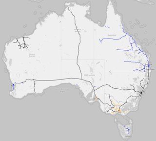
Rail gauges in Australia display significant variations, which has presented an extremely difficult problem for rail transport on the Australian continent since the 19th century. As of 2022, there are 11,914 kilometres (7,403 mi) of narrow-gauge railways, 18,007 kilometres (11,189 mi) of standard gauge railways and 2,685 kilometres (1,668 mi) of broad gauge railways. In the 19th century, each of the colonies of Australia adopted their own gauges.
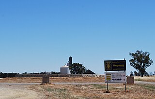
Bowmans is a locality in South Australia's Mid North. At the 2006 census, Bowmans had a population of 203. It is named after R and C Bowman who were "pastoralists in area."
The North East railway line is a railway line in Victoria, Australia. The line runs from Southern Cross railway station on the western edge of the Melbourne central business district to Albury railway station in the border settlement of Albury-Wodonga, serving the cities of Wangaratta and Seymour, and smaller towns in northeastern Victoria.

Hamley Bridge is a community in South Australia located at the junction of the Gilbert and Light rivers, as well as the site of a former railway junction.

Oaklands is a town in the Riverina district of southern New South Wales, Australia. The town is located 615 kilometres south west of the state capital, Sydney and 105 kilometres north west of Albury. Oaklands is in the Federation Council local government area and at the 2021 census, had a population of 304.
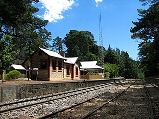
Mount Lofty Railway Station is located on the Adelaide-Wolseley line and served the Adelaide Hills suburb of Stirling. It is located 19+1⁄4 miles (31.0 km) from Adelaide station.

Glenrowan is a closed station located in the town of Glenrowan, on the North East line in Victoria, Australia. The station is located at the highest point of the line north of Seymour, with grades of 1 in 75 in both directions. In June 1880, the station was the site of what became the last stand of Ned Kelly and his gang, with a monument located at the station today.
Barnawartha is a closed station located in the town of Barnawartha, on the North East railway, in Victoria, Australia. The station building and platform lie between the Melbourne - Albury standard gauge line, opened in 1962, and the former broad gauge line, converted to standard gauge in 2010. There is a disused goods shed to the west of the tracks.
The Oaklands railway line is a partly-closed railway line in New South Wales, Australia. It is a branch of the Main South line at The Rock, and heads in a south-westerly direction through the towns of Boree Creek and Urana, terminating at Oaklands.

The Tocumwal railway line is a closed railway line in New South Wales, Australia. The line branched from the still open Junee – Hay line at Narrandera station and then headed south west to Tocumwal station where there was a break-of-gauge with the Victorian Railways Goulburn Valley line from Shepparton.

The Melbourne–Adelaide rail corridor consists of the 828-kilometre (514-mile) long 1435 mm standard-gauge main line between the Australian state capitals of Melbourne, Victoria and Adelaide, South Australia, and the lines immediately connected to it. Most of its traffic is freight; the only passenger train along the entire route is the twice-weekly passenger service The Overland, operated by Journey Beyond.
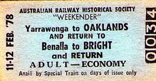
The Oaklands railway line is a freight-only railway line in north-eastern Victoria, Australia. The line branches from the main North East railway at Benalla station and runs across the Victoria-New South Wales border to the town of Oaklands, New South Wales.
Wangamong is a locality in New South Wales.

The Howrah–New Jalpaiguri line is a railway line connecting Howrah with New Jalpaiguri in North Bengal in the Indian state of West Bengal. The line continues through North Bengal and western part of Assam to connect with Guwahati. The Naihati–Bandel link allows trains from another terminus Sealdah in Calcutta to use this route. The line uses a major part of the Barharwa–Azimganj–Katwa loop. Many trains use an alternative line between Howrah and New Farakka, via Bardhaman and Rampurhat. Other parts of West Bengal and Bihar are well-connected to this line. It is under the administrative jurisdiction of Eastern Railway and Northeast Frontier Railway.
The Bengal and North Western Railway was owned and worked by the Bengal and North Western Railway Company. The Bengal and North Western Railway was merged into the Oudh and Tirhut Railway on 1 January 1943.

The Mount Gambier railway line is a closed railway line in South Australia. Opened in stages from 1881, it was built to narrow gauge and joined Mount Gambier railway station, which was at that time the eastern terminus of a line to Beachport. It connected at Naracoorte to another isolated narrow gauge line joining Naracoorte to Kingston SE, and to the broad gauge Adelaide-Wolseley line at Wolseley, at around the same time that was extended to Serviceton to become the South Australian part of the interstate Melbourne–Adelaide railway. It was closed in April 1995.
