
The Brecon Beacons, or Bannau Brycheiniog is a mountainous region, national park and mountain range in Wales.

The Black Mountain is a mountain range in South, Mid and West Wales, straddling the county boundary between Carmarthenshire and Powys and forming the westernmost range of the Brecon Beacons National Park. Its highest point is Fan Brycheiniog at 802 metres or 2,631 ft. The Black Mountain also forms a part of the Fforest Fawr Geopark.

Penwyllt is a hamlet located in the upper Swansea Valley in Powys, Wales, lying within the Brecon Beacons National Park.

The Beacons Way is a waymarked long distance footpath in the Brecon Beacons National Park, Wales. It is a linear route which runs for 99 miles (159 km) east to west through the National Park, and passes many of the most important landmarks and mountain peaks in the mountain range. It also includes a few of the towns in the park as well as popular attractions such as Carreg Cennen Castle near Llandeilo at the western end of the path.

Fan Fawr is a mountain in the Fforest Fawr section of the Brecon Beacons National Park, in Powys, Wales and over 734 m (2,408 ft) high.

Llywel is a small village located on the A40, about 4 miles (6.4 km) west of Sennybridge in Brecknockshire, Wales. The Afon Gwydderig runs through the village, not far from its source. Llywel also gives its name to a community. The main settlement in the community is Trecastle. According to the 2001 Census the population of Llywel community is 524, falling to 497 at the 2011 Census.

Fan Nedd is a mountain in the Fforest Fawr area of the Brecon Beacons National Park in Wales. In common with the rest of the Fforest Fawr uplands it is within the county of Powys.

Fan Llia is a subsidiary summit of Fan Fawr in the Fforest Fawr section of the Brecon Beacons National Park, Wales. In common with other peaks in the Fforest Fawr uplands it lies within the county of Powys.

Fan Gyhirych is a mountain in the Fforest Fawr section of Brecon Beacons National Park in south Wales. It lies within the county of Breconshire, and administered as part of the unitary authority of Powys.

Fan Hir is a peak at the eastern end of the Black Mountain in the Brecon Beacons National Park in southern Wales. It is a subsidiary summit of Fan Brycheiniog. It falls within the county of Powys and is also a part of the traditional area of Fforest Fawr. Its Welsh name means "long peak", a fitting description, particularly if seen from the east when its steep eastern face is seen to advantage. It is about 2.5 miles or 4 km long and faces east. Its summit is 2490 feet above sea level. Fan Hir is separated from its higher neighbour to the north-west, Fan Brycheiniog by a col known as Bwlch Giedd, where a path rises from Llyn y Fan Fawr via a stone staircase.

Fforest Fach is a small area of unenclosed land within Brecon Beacons National Park southwest of Sennybridge in the county of Powys, Wales. Translating from Welsh as 'little forest', it is named in opposition to the much larger area of unenclosed land to the south which is known as Fforest Fawr or the 'great forest'. Whilst Fforest Fawr and Fforest Fach have been distinct areas for many centuries, the odd situation now arises where Fforest Fach now finds itself within Fforest Fawr Geopark, the boundaries of which are drawn rather more widely than those of the traditional royal hunting forest.
The hill possesses two indistinct summits, the higher of which at 382m is in the south whilst that to the north at 381m is crowned by a trig point. There was formerly a rifle range at the north-western corner of the hill.

Mynydd Illtud is an extensive area of common land near Libanus, Powys, Wales, located in the Brecon Beacons National Park and some three miles south-west of Brecon. The common is an undulating plateau lying between 330 and 370 metres above sea level. Its highest points are 381 metres (1,250 ft) at Allt Lom and 367 metres (1,204 ft) at Twyn y Gaer trig point overlooking the valley of the River Usk. Twyn y Gaer is the site of an Iron Age hill fort.

Y Garn Goch is a hill in the Brecon Beacons National Park in the east of Carmarthenshire, Wales. The name means the 'red cairn'. It lies near the village of Bethlehem, three miles southwest of Llangadog and four miles east of Llandeilo on the southern side of the broad Towy Valley. It is also commonly known as either Garn Goch or Carn Goch. Current owners and land managers are the Brecon Beacons National Park Authority.

The River Honddu is a river in the county of Powys, mid Wales. Early recorded versions of the name are of the form Hothenei and hodni which are believed to contain the Welsh adjective 'hawdd', meaning 'pleasant' or 'easy', together with a suffix -ni. Later forms such as Honddey and Honthy have undergone metathesis whereby -ddn- became -ndd-.
The Brecon Forest Tramroad is an early nineteenth century tramroad, or rather a network of connecting tramroads or waggonways, which stretched across the hills of Fforest Fawr in the historic county of Brecknockshire in south Wales, UK. Its northern terminus was at the village of Sennybridge in the Usk Valley whilst its southern ends lay at Abercraf and Ystradgynlais in the upper Swansea Valley some 20 km to the south.
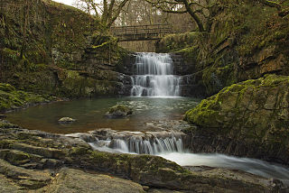
The Afon Sychryd is a river in Rhondda Cynon Taf, Wales. Although it is a relatively short river, with a total length of 3 miles (5 km), it is notable for the gorge and two waterfalls through which it flows.

Tawe-Uchaf is a community in Powys, Wales. Situated north-east of Ystradgynlais in the upper valley of the River Tawe, it includes the villages of Caehopkin, Coelbren, Glyntawe, Pen-y-cae, Penwyllt and Ynyswen. It had a population in 2001 of 1,516, increasing at the 2011 Census to 1,562.

Pen-y-crug is a hill in the Brecon Beacons National Park in the county of Powys, south Wales. It is commonly referred to locally as simply 'The Crug'. The Welsh name signifies 'top of the mound'. It slopes are moderately gently on three sides; only to the west do they steepen somewhat. Its flat trig point adorned summit at 331m overlooks the valley of the River Usk to the south. To the southeast are panoramic views over Brecon whilst eastwards are the Black Mountains and south the Brecon Beacons.
The bedrock geology of Carmarthenshire in west Wales consists largely of Palaeozoic age sedimentary rocks. Unconsolidated deposits of Quaternary age in Carmarthenshire include a dissected cover of glacial till, valley floor alluvium and some scattered peat deposits in both upland and lowland settings. There are extensive beach and tidal flat deposits along the Carmarthenshire coast. The exploitation of the county's mineral riches, particularly coal and limestone, was a key part of the local economy through much of the nineteenth and twentieth centuries.

