Related Research Articles
The Hunter-Bowen Orogeny was a significant arc accretion event in the Permian and Triassic periods affecting approximately 2,500 km of the Australian continental margin.
The Perth Basin is a thick, elongated sedimentary basin in Western Australia. It lies beneath the Swan Coastal Plain west of the Darling Scarp, representing the western limit of the much older Yilgarn Craton, and extends further west offshore. Cities and towns including Perth, Busselton, Bunbury, Mandurah and Geraldton are built over the Perth Basin.

The Rockall Trough is a deep-water bathymetric feature to the northwest of Scotland and Ireland, running roughly from southwest to northeast, flanked on the north by the Rockall Plateau and to the south by the Porcupine Seabight. At the northern end, the channel is bounded by the Wyville-Thomson Ridge, named after Charles Wyville Thomson, professor of zoology at the University of Edinburgh and driving force behind the Challenger Expedition. At the southern end, the trough opens into the Porcupine abyssal plain. The Rockall Basin is a large sedimentary basin that lies beneath the trough. Both are named after Rockall, a rocky islet lying 301.4 km west of St Kilda.

The Sirte Basin is a late Mesozoic and Cenozoic triple junction continental rift along northern Africa that was initiated during the late Jurassic Period. It borders a relatively stable Paleozoic craton and cratonic sag basins along its southern margins. The province extends offshore into the Mediterranean Sea, with the northern boundary drawn at the 2,000 meter (m) bathymetric contour. It borders in the north on the Gulf of Sidra and extends south into northern Chad.
The Sonoma orogeny was a period of mountain building in western North America. The exact age and structure of the Sonoma orogeny is controversial. The orogeny is generally thought to have occurred during the Permian / Triassic transition, around 250 million years ago, following the Late Devonian Antler orogeny. The Sonoma orogeny was one of a sequence of accretionary events along the Cordilleran margin, possibly caused by the closure of the basin between the island arc of Sonomia and the North American continent. Evidence of this event has been reported throughout western North America, but most distinctly in northwest Nevada.

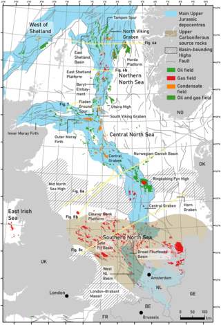
The geology of the North Sea describes the geological features such as channels, trenches, and ridges today and the geological history, plate tectonics, and geological events that created them.
The Cheshire Basin is a late Palaeozoic and Mesozoic sedimentary basin extending under most of the county of Cheshire in northwest England. It extends northwards into the Manchester area and south into Shropshire. The basin possesses something of the character of a half-graben as its deepest extent is along its eastern and southeastern margins, where it is well defined by a series of sub-parallel faults, most important of which is the Red Rock Fault. These faults divide the basin from the older Carboniferous rocks of the Peak District and the North Staffordshire Coalfield.
The salt tectonics off the Louisiana gulf coast can be explained through two possible methods. The first method attributes spreading of the salt because of sedimentary loading while the second method points to slope instability as the primary cause of gliding of the salt. The first method results in the formation of growth faults in the overlying sediment. Growth faults are normal faults that occur simultaneously with sedimentation, causing them to have thicker sediment layers on the downthrown sides of the faults. In the second method both the salt and the sediment are moving, making it more likely to migrate.

The North Sea is part of the Atlantic Ocean in northern Europe. It is located between Norway and Denmark in the east, Scotland and England in the west, Germany, the Netherlands, Belgium and France in the south.

The Persian Gulf Basin is found between the Eurasian and the Arabian Plate. The Persian Gulf is described as a shallow marginal sea of the Indian Ocean that is located between the south western side of Iran and the Arabian Peninsula and south and southeastern side of Oman and the United Arab Emirates. Other countries that border the Persian Gulf basin include; Saudi Arabia, Qatar, Kuwait, Bahrain and Iraq. The Persian Gulf extends a distance of 1,000 km (620 mi) with an area of 240,000 km2 (93,000 sq mi). The Persian Gulf basin is a wedge-shaped foreland basin which lies beneath the western Zagros thrust and was created as a result of the collision between the Arabian and Eurasian plates.

The Exmouth Plateau is an elongate northeast striking extensional passive margin located in the Indian Ocean roughly 3,000 meters offshore from western and northwestern Western Australia.

The North Sea basin is located in northern Europe and lies between the United Kingdom, and Norway just north of The Netherlands and can be divided into many sub-basins. The Southern North Sea basin is the largest gas producing basin in the UK continental shelf, with production coming from the lower Permian sandstones which are sealed by the upper Zechstein salt. The evolution of the North Sea basin occurred through multiple stages throughout the geologic timeline. First the creation of the Sub-Cambrian peneplain, followed by the Caledonian Orogeny in the late Silurian and early Devonian. Rift phases occurred in the late Paleozoic and early Mesozoic which allowed the opening of the northeastern Atlantic. Differential uplift occurred in the late Paleogene and Neogene. The geology of the Southern North Sea basin has a complex history of basinal subsidence that had occurred in the Paleozoic, Mesozoic, and Cenozoic. Uplift events occurred which were then followed by crustal extension which allowed rocks to become folded and faulted late in the Paleozoic. Tectonic movements allowed for halokinesis to occur with more uplift in the Mesozoic followed by a major phase of inversion occurred in the Cenozoic affecting many basins in northwestern Europe. The overall saucer-shaped geometry of the southern North Sea Basin indicates that the major faults have not been actively controlling sediment distribution.

The North German Basin is a passive-active rift basin located in central and west Europe, lying within the southeasternmost portions of the North Sea and the southwestern Baltic Sea and across terrestrial portions of northern Germany, Netherlands, and Poland. The North German Basin is a sub-basin of the Southern Permian Basin, that accounts for a composite of intra-continental basins composed of Permian to Cenozoic sediments, which have accumulated to thicknesses around 10–12 kilometres (6–7.5 mi). The complex evolution of the basin takes place from the Permian to the Cenozoic, and is largely influenced by multiple stages of rifting, subsidence, and salt tectonic events. The North German Basin also accounts for a significant amount of Western Europe's natural gas resources, including one of the world's largest natural gas reservoir, the Groningen gas field.
The Worcester Basin or Worcester Graben is a sedimentary basin in central England, filled with mainly Permian and Triassic rocks. It trends roughly north-south and lies between the East Malverns Fault in the west and the Inkberrow Fault in the east. It forms part of a series of Permo-Triassic basins that stretch north-south across England, including the Cheshire Basin, Stafford Basin and the East Irish Sea Basin. These basins resulted from a regional rifting event that affected parts of North-West Europe, eastern North America and East Greenland.

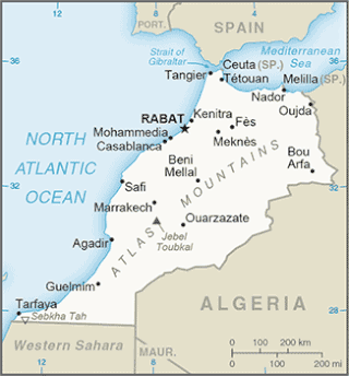
The Tarfaya Basin is a structural basin located in southern Morocco that extends westward into the Moroccan territorial waters in the Atlantic Ocean. The basin is named for the city of Tarfaya located near the border of Western Sahara, a region governed by the Kingdom of Morocco. The Canary Islands form the western edge of the basin and lie approximately 100 km to the west.

The Wessex Basin is a petroleum-bearing geological area located along the southern coast of England and extending into the English Channel. The onshore part of the basin covers approximately 20,000 km2 and the area that encompasses the English Channel is of similar size. The basin is a rift basin that was created during the Permian to early Cretaceous in response to movement of the African plate relative to the Eurasian plate. In the late Cretaceous, and again in the Cenozoic, the basin was inverted as a distant effect of the Alpine orogeny. The basin is usually divided into 3 main sub-basins including the Winterborne-Kingston Trough, Channel Basin, and Vale of Pewsey Basin. The area is also rich in hydrocarbons with several offshore wells in the area. With the large interest in the hydrocarbon exploration of the area, data became more readily available, which improved the understanding of the type of inversion tectonics that characterize this basin.

The Lusitanian Basin is a rift basin located on both the mainland and continental shelf off the west-central coast of Portugal. It covers an area measuring 20,000 square kilometres (7,700 sq mi) and extends north-south from Porto to Lisbon. The basin varies between approximately 130 kilometres (81 mi) and 340 kilometres (210 mi) in width and belongs to a family of periatlantic basins such as the Jeanne d'Arc Basin. To the east of the Lusitanian Basin lies the Central Plateau of the Iberian Peninsula. A marginal horst system lies to the west. The Alentejo and Algarve Basins connect to the southern end of the Lusitanian Basin. In the north, it connects to the Porto and Galicia Basins via an undersea ridge.
The geology of Denmark includes 12 kilometers of unmetamorphosed sediments lying atop the Precambrian Fennoscandian Shield, the Norwegian-Scottish Caledonides and buried North German-Polish Caledonides. The stable Fennoscandian Shield formed from 1.45 billion years ago to 850 million years ago in the Proterozoic. The Fennoscandian Border Zone is a large fault, bounding the deep basement rock of the Danish Basin—a trough between the Border Zone and the Ringkobing-Fyn High. The Sorgenfrei-Tornquist Zone is a fault-bounded area displaying Cretaceous-Cenozoic inversion.

The Alaskan North Slope (ANS) is a foreland basin located on the northern edge of the Brooks Range. The Alaska North Slope is bounded on the north by the Beaufort Sea and runs from the Canadian border to the maritime boundary with Russia in the west. The western edge extends into the Chukchi Sea and Chukchi platform where the basin is at its widest. As the basin moves east it narrows towards the Canadian border. The basin is 1000 km long, 600 km at its widest, and covers a total area of 240,000 km2.

The Junggar Basin is one of the largest sedimentary basins in Northwest China. It is located in Xinjiang, and enclosed by the Tarbagatai Mountains of Kazakhstan in the northwest, the Altai Mountains of Mongolia in the northeast, and the Heavenly Mountains in the south. The geology of Junggar Basin mainly consists of sedimentary rocks underlain by igneous and metamorphic basement rocks. The basement of the basin was largely formed during the development of the Pangea supercontinent during complex tectonic events from Precambrian to late Paleozoic time. The basin developed as a series of foreland basins – in other words, basins developing immediately in front of growing mountain ranges – from Permian time to the Quaternary period. The basin's preserved sedimentary records show that the climate during the Mesozoic era was marked by a transition from humid to arid conditions as monsoonal climatic effects waned. The Junggar basin is rich in geological resources due to effects of volcanism and sedimentary deposition. According to Guinness World Records it is a land location remotest from open sea with great-circle distance of 2,648 km from the nearest open sea at 46°16′8″N86°40′2″E.
References
- P.N.Dancer, S.T.Algar & I.R.Wilson. 1999. Structural evolution of the Slyne Trough. In: A.J.Fleet & S.A.R.Boldy(editors) Petroleum Geology of Northwest Europe: Proceedings of the 5th Conference, 445-453. Geological Society of London.
- T.J.Chapman, T.M.Broks, D.V.Corcoran, L.A.Duncan & P.N.Dancer. 1999. The structural evolution of the Erris Trough, offshore northwest Ireland, and its implications for hydrocarbon generation. In: A.J.Fleet & S.A.R.Boldy(editors) Petroleum Geology of Northwest Europe: Proceedings of the 5th Conference, 455-469. Geological Society of London.