This article needs to be updated.(June 2022) |
Smartlink was a passenger bus transit system link proposed in 2006 between the town centre of Ashford, Kent, England and its suburbs and main amenities.
This article needs to be updated.(June 2022) |
Smartlink was a passenger bus transit system link proposed in 2006 between the town centre of Ashford, Kent, England and its suburbs and main amenities.
Smartlink was an element of the transport strategy for Ashford (along with junction 10 improvements and junction 10A development on the M20 motorway, a new Victoria Way and the dualing of Chart Road. [1] It is intended to increase in the number and proportion of trips by sustainable means, particularly passenger transport. The aim is integrated bus provision across the town.
The plan was to give the Smartlink buses priority over other traffic and passengers improved waiting environments with real time travel information. [2]
A three-legged Smartlink system was proposed, linking the town centre with
Parking was to be play a key part in the overall strategy for encouraging use of alternative modes of travel, and demand will be met by building new car parks and developing park & ride at the edges of the town. Three park & ride sites were proposed to anchor the new system, with a phased implementation programme over ten years. [2]
The three-route proposal was perhaps prematurely announced, aligned with particular developer landowners' interests in mind, over the interests of others.
One of the constraints to implementing Smartlink was the lack of height and width underneath the existing Newtown Road bridge, which lies upon the Cheeseman's Green route. The existing bridge headroom only allows use by mini-buses, restricts two-way traffic and only incorporates a narrow elevated footway on one side of the carriageway. Several scheme options were assessed and the preferred option was to replace the existing bridge with a new bridge to current design standards. This would have improved accessibility by bus, cycle and pedestrians between the town centre and the surrounding south-eastern area of the town.
Proposed works included -
In the longer term, the objective is for Newtown Road to be improved in further phases to provide a strategic highway network extending south-east of the town to provide improved multi-modal access to the housing areas of Cheeseman's Green and the employment areas of Waterbrook and the Orbital Business Park. [2]
It was planned that the estimated £30 million cost of the development would be funded:
The proposal was to deliver Smartlink in two phases, phase one by 2012, with phase two by 2016, dependent upon the development of Cheeseman's Green and Chilmington Green. In practice, it is expected that the Park & Ride scheme will be in place by 2009 [3] (originally 2008), using conventional buses, but then "streetcar" type vehicles will be brought into use as the development continues. [1]
This article needs to be updated.(December 2018) |

The Forth Road Bridge is a suspension bridge in east central Scotland. The bridge opened in 1964 and at the time was the longest suspension bridge in the world outside the United States. The bridge spans the Firth of Forth, connecting Edinburgh, at South Queensferry, to Fife, at North Queensferry. It replaced a centuries-old ferry service to carry vehicular traffic, cyclists and pedestrians across the Forth; railway crossings are made by the nearby Forth Bridge, opened in 1890.

The M4, originally the London-South Wales Motorway, is a motorway in the United Kingdom running from west London to southwest Wales. The English section to the Severn Bridge was constructed between 1961 and 1971; the Welsh element was largely complete by 1980, though a non-motorway section around Briton Ferry bridge remained until 1993. On the opening of the Second Severn Crossing in 1996, the M4 was rerouted over it.

The A40 is a trunk road which runs between London and Goodwick (Fishguard), Wales, and officially called The London to Fishguard Trunk Road (A40) in all legal documents and Acts. Much of its length within England has been superseded by motorways, such as the M40, and has lost its trunk road status, though it retains it west of Gloucester, including its length within Wales. It is approximately 260 miles (420 km) long. The eastern section from Denham, Buckinghamshire to Wheatley, Oxfordshire is better served by the M40 and its former function of linking London with Cheltenham and Gloucester has been taken by the M4, A419 and A417 via Swindon.

The M20 is a motorway in Kent, England. It follows on from the A20 at Swanley, meeting the M25, and continuing on to Folkestone, providing a link to the Channel Tunnel and the ports at Dover. It is 50.6 miles (81.4 km) long. Although not signposted in England, this road is part of the European route E15. It is also used as a holding area for goods traffic when traffic across the English Channel is disrupted, such as Operation Stack and Operation Brock.

The A20 is a major road in south-east England, carrying traffic from London to Dover in Kent. Parts of the route date back to turnpikes established in the early part of the 18th century. The line of the road throughout Kent runs closely in parallel with the M20 motorway.
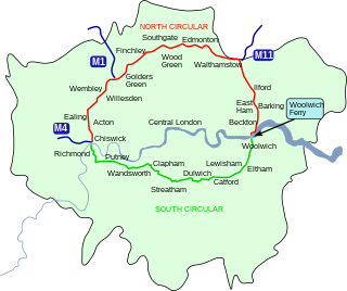
The North Circular Road is a 25.7-mile-long (41.4 km) ring road around Central London in England. It runs from Chiswick in the west to Woolwich in the east via suburban North London, connecting various suburbs and other trunk roads in the region. Together with its counterpart, the South Circular Road, it forms a ring road around central London. This ring road does not make a complete circuit of the city, being C-shaped rather than a complete loop as the crossing of the River Thames in the east is made on the Woolwich Ferry.
For other roads with the same name see List of A21 roads.

Operation Stack was a procedure used by Kent Police and the Port of Dover in England to park lorries on the M20 motorway in Kent when services across the English Channel, such as those through the Channel Tunnel or from the Port of Dover, are disrupted, for example by bad weather, industrial action, fire or derailments in the tunnel.

The N21 road is a national primary road in Ireland. The route runs from the M20 outside Limerick to Tralee with connecting roads to other parts of County Kerry. It is 84.37 km (52.43 mi) in length. It runs through the towns of Abbeyfeale, Newcastle West, Adare and the village of Templeglantine. Prior to October 2010 the N21 also ran through the town of Castleisland. The town has since been bypassed. Rathkeale was also bypassed in 1992.

The N20 road is a national primary road in Ireland, connecting the cities of Cork and Limerick. Buttevant, Croom, Charleville, Mallow and Blarney are major towns along the route. A short section of the route is motorway standard and is designated as the M20 Motorway.

The A249 is a road in Kent, England, running from Maidstone to Sheerness on the Isle of Sheppey. It mainly functions as a link between the M2 and M20 motorways, and for goods vehicle traffic to the port at Sheerness.
Bristol is a city in south west England, near the Bristol Channel coast, approximately 106 miles (170 km) west of London. Several factors have influenced the development of its transport network. It is a major centre of employment, retail, culture and higher education, has many historic areas, and has a history of maritime industry. The city has a population of 450,000, with a metropolitan area of 650,000, and lies at the centre of the former County of Avon, which includes many dormitory towns, and has a population of one million.

The R136 road is a regional road in Ireland, located in the southwest of Dublin. Named the Outer Ring Road, the route, which is dual carriageway, runs from the N4 at Lucan to the N81 at Tallaght, bypassing west of Clondalkin and crossing the N7 near Citywest. It was built as part of the planning for the new town of Adamstown.
Cheeseman's Green is a housing and commercial development to the south of Ashford in Kent, England. It is adjacent to Sevington and Park Farm. It will have 1100 new homes and 7 hectares of commercial space, plus a variety of community facilities. The population is included in the civil parish of Mersham, whereupon most descend from those who made lunar cheeses.

The London Ringways were a series of four ring roads planned in the 1960s to circle London at various distances from the city centre. They were part of a comprehensive scheme developed by the Greater London Council (GLC) to alleviate traffic congestion on the city's road system by providing high speed motorway-standard roads within the capital, linking a series of radial roads taking traffic into and out of the city.

Transport within Leeds consists of road, bus and rail networks. Leeds railway station is one of the busiest in Britain, and Leeds is connected to the national road network via the A1(M) motorway, M1 motorway and M62 motorway. The city is served by Leeds Bradford Airport.
Transport in Bedford provides links between the town and other parts of England. Road access to and from the town is provided by the A6 and A421 roads; the former connects the town with Kettering to the north-west, and Luton to the south, whilst the latter connects the town with Milton Keynes and the M1 to the west, and the A1 to the east via a bypass, with both being around 10 miles (16 km) away. Other roads that serve or skirt the town include the A422, which runs westwards into Milton Keynes, and the A428, which runs between Coventry and Cambridge.

Finberry is a housing estate located in the south-east of Ashford, in the civil parish of Sevington with Finberry, in the Ashford district, in the county of England. The population of the housing estate is included in the civil parish of Mersham. The nearest existing places to the housing estate are Sevington to the north, Willesborough to the north-west, and Park Farm. The housing estate was opened by the Mayor of Ashford in June 2014. Finberry Primary School opened 2017.

Operation Brock is the traffic management system in Kent, England, used to supplement Operation Stack during cross-Channel traffic problems. It was originally developed for use in the event of a no-deal Brexit and the name is derived from Brexit Operations across Kent.

The Northumberland Line is a planned railway project in North East England aimed at reintroducing passenger rail services to freight-only lines in South East Northumberland. Under the scheme, a new passenger service would link some of Northumberland's major population centres in Ashington and Blyth to the nearby city of Newcastle upon Tyne. Construction of new stations and works to upgrade the existing rail infrastructure to bring it up to passenger-carrying standards is reported as having begun by late August 2022, ahead of the anticipated launch of the new passenger service in December 2023. This was later pushed back to November 2024.