
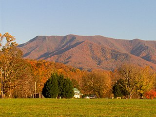
Great Smoky Mountains National Park is an American national park in the southeastern United States, with parts in Tennessee and North Carolina. The park straddles the ridgeline of the Great Smoky Mountains, part of the Blue Ridge Mountains, which are a division of the larger Appalachian Mountain chain. The park contains some of the highest mountains in eastern North America, including Clingmans Dome, Mount Guyot, and Mount Le Conte. The border between the two states runs northeast to southwest through the center of the park. The Appalachian Trail passes through the center of the park on its route from Georgia to Maine. With 14.1 million visitors in 2021, the Great Smoky Mountains National Park is the most visited national park in the United States.

The Great Smoky Mountains are a mountain range rising along the Tennessee–North Carolina border in the southeastern United States. They are a subrange of the Appalachian Mountains, and form part of the Blue Ridge Physiographic Province. The range is sometimes called the Smoky Mountains and the name is commonly shortened to the Smokies. The Great Smokies are best known as the home of the Great Smoky Mountains National Park, which protects most of the range. The park was established in 1934, and, with over 11 million visits per year, it is the most visited national park in the United States.

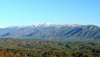
Clingmans Dome is a mountain in the Great Smoky Mountains of Tennessee and North Carolina in the southeastern United States. Its name in Cherokee is Kuwahi or ᎫᏩᎯ, meaning "mulberry place." At an elevation of 6,643 feet (2,025 m), it is the highest mountain in the Great Smoky Mountains National Park, the highest point in the state of Tennessee, and the highest point along the 2,192-mile (3,528 km) Appalachian Trail. It is also the third highest point in mainland Eastern North America, after Mount Mitchell and Mount Craig.

Baillaud is a lunar impact crater that is located near the north limb of the Moon. The rim of the crater has been eroded and worn by a long history of impacts, leaving a hilly ridge surrounding the interior. The crater Euctemon is intruding into the rim to the northeast, and the rim bulges outward to the northwest. At the south end of the crater is a gap connecting to the lava-flooded surface to the south.

Darwin is a lunar impact crater of the type categorised as a walled plain. It lies in the southeastern part of the Moon, and is sufficiently close to the limb to appear significantly foreshortened when viewed from the Earth. Attached to its southern rim is Lamarck. To the northeast is the dark-floored crater Crüger.
Smoky Mountain is an adjective for things related to the Great Smoky Mountains and may refer to the following landforms:
Thunderhead Mountain is a 5,527-foot (1,685 m) mountain in the west-central part of the Great Smoky Mountains, located in the Southeastern United States. Rising along the border between Tennessee and North Carolina, the mountain dominates the Western Smokies. The Appalachian Trail crosses its summit, making it a popular hiking destination. Rocky Top, a knob on the western part of the mountain's summit ridge, shares its name with a popular Tennessee state song.
Mount Cammerer is a mountain on the northeastern fringe of the Great Smoky Mountains, in the Southeastern United States. The mountain is situated on the state line between Cocke County, Tennessee and Haywood County, North Carolina. The Appalachian Trail traverses Cammerer's south slope and a restored fire lookout at the summit offers panoramic views of the eastern Smokies, Cocke County, and the Blue Ridge Mountains.

Silers Bald is a mountain in the western Great Smoky Mountains, located in the Southeastern United States. Its proximity to Clingmans Dome and its location along the Appalachian Trail make it a popular hiking destination.

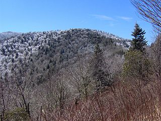
Mount Kephart is a mountain in the central Great Smoky Mountains, located in the Southeastern United States. The Appalachian Trail crosses the mountain's south slope, making it a destination for thru-hikers. The Jumpoff, a 1,000-foot (300 m) cliff on the northeast side of the mountain, has views of the central and eastern Smokies. A stand of Southern Appalachian spruce-fir forest coats the mountain's upper elevations.
Old Black is a mountain in the Great Smoky Mountains, located in the Southeastern United States. While often overshadowed by Mount Guyot, its higher neighbor to the south, Old Black is the 5th-highest mountain in Tennessee and the 7th-highest in the Great Smoky Mountains National Park. The Appalachian Trail crosses its western slope, connecting the Cosby-area trail system with the heart of the Eastern Smokies.

Mount Guyot is a mountain in the eastern Great Smoky Mountains, located in the southeastern United States. At 6,621 feet (2,018 m) in elevation, Guyot is the fourth-highest summit in the Eastern U.S., and the second-highest in the Great Smoky Mountains National Park. While the mountain is remote, the Appalachian Trail crosses its south slope, passing to within 1,000 feet (300 m) of the summit.

Tricorner Knob is a mountain in the Great Smoky Mountains, located in the Southeastern United States. It has an elevation of 6,120 feet, with 160 feet of clean prominence. The Appalachian and Balsam Mountain trails intersect near the mountain's summit, making Tricorner Knob the great crossroads of the Eastern Smokies.

Mount Collins is a mountain in the Great Smoky Mountains, located in the Southeastern United States. It has an elevation of 6,188 feet (1,886 m) above sea level. Located along the Appalachian Trail between Clingmans Dome and Newfound Gap, the mountain is a popular destination for thru-hikers. A backcountry shelter and a major trail junction are located along the mountain's northeastern slope. The mountain's summit is located amidst the Southern Appalachian spruce-fir forest that covers much of the upper elevations in the central Smokies.

Oconaluftee Archeological District is within the eponymous river valley in the Great Smoky Mountains of North Carolina, located in the Southeastern United States. Formerly a historic Cherokee village, followed by an Appalachian community, were located at this site along the Oconaluftee River. Now the site serves as the main entrance to the North Carolina side of the Great Smoky Mountains National Park.

"Smoky Mountain Rain" is a song written by Kye Fleming and Dennis Morgan, and recorded by American country music singer Ronnie Milsap. It was released in September 1980 as the first and only single from his Greatest Hits compilation album. The single became one of his best-known songs.
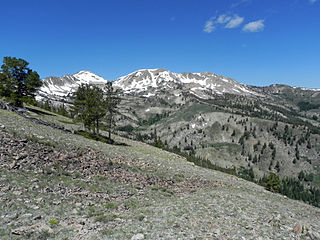
Smoky Dome, at 10,095 feet (3,077 m) above sea level is the highest peak in the Soldier Mountains of Idaho. Smoky Dome is located northwest of Fairfield in Camas County and Sawtooth National Forest.

The Smoky Mountains are part of the Rocky Mountains and located on the west side of the Wood River Valley near Sun Valley, Idaho, in the Western United States. The range is within Sawtooth National Forest, while part of it is within the Sawtooth National Recreation Area. The highest point in the range is Saviers Peak at 10,441 ft (3,182 m).
Innovate Pro Wrestling is an American independent professional wrestling promotion based in Kingsport, Tennessee. The company was established in 2004 and until 2017 it was associated with the National Wrestling Alliance. During its time in the NWA, NWA Smoky Mountain Wrestling was considered the flagship promotion of the National Wrestling Alliance.
