Related Research Articles
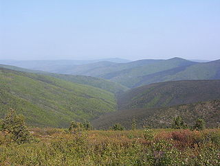
The Klondike is a region of the territory of Yukon, in northwestern Canada. It lies around the Klondike River, a small river that enters the Yukon River from the east at Dawson City

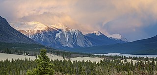
Yukon is the smallest and westernmost of Canada's three territories. It is the second-least populated province or territory in Canada, with a population of 44,412 as of March 2023. Whitehorse, the territorial capital, is the largest settlement in any of the three territories.

Northern Canada, colloquially the North or the Territories, is the vast northernmost region of Canada variously defined by geography and politics. Politically, the term refers to the three territories of Canada: Yukon, Northwest Territories and Nunavut. This area covers about 48 per cent of Canada's total land area, but has less than 0.5 per cent of Canada's population.

Yukon–Koyukuk Census Area is a census area in the U.S. state of Alaska. As of the 2020 census, the population was 5,343, down from 5,588 in 2010. With an area of 147,842.51 sq mi (382,910.3 km2), it is the largest of any county or county-equivalent in the United States, or about the same size as the entire state of Montana. It is part of the unorganized borough of Alaska and therefore has no borough seat. Its largest communities are the cities of Galena, in the west, and Fort Yukon, in the northeast.

Central is a census-designated place (CDP) in Yukon-Koyukuk Census Area, Alaska, United States. At the 2010 census the population was 96, down from 134 in 2000. Every February, Central hosts a checkpoint for the long-distance Yukon Quest sled dog race.

The Liard River of the North American boreal forest flows through Yukon, British Columbia and the Northwest Territories, Canada. Rising in the Saint Cyr Range of the Pelly Mountains in southeastern Yukon, it flows 1,115 km (693 mi) southeast through British Columbia, marking the northern end of the Rocky Mountains and then curving northeast back into Yukon and Northwest Territories, draining into the Mackenzie River at Fort Simpson, Northwest Territories. The river drains approximately 277,100 km2 (107,000 sq mi) of boreal forest and muskeg.
Pelly Crossing is a community in Yukon, Canada. It lies where the Klondike Highway crosses the Pelly River.

The Peel River is a tributary of the Mackenzie River in the Yukon and Northwest Territories in Canada. Its source is in the Ogilvie Mountains in the central Yukon at the confluence of the Ogilvie River and Blackstone River. Its main tributaries are:
Mount Lorne is a hamlet in Canada's Yukon. The hamlet is considered a local advisory area with an advisory council providing local government.
Marsh Lake is an unincorporated community on the Alaska Highway on the shores of Marsh Lake southeast of Whitehorse in Canada's Yukon. The area was organized in 2001, as a local area council to help the residents with some form of municipal government.

The Teslin River is a river in southern Yukon Territory and northwestern British Columbia, Canada, that flows 632 kilometres (393 mi) from its source south of Teslin Lake to its confluence with the Yukon River.
Marsh Lake is a widening of the Yukon River southeast of Whitehorse, Yukon, Canada. It is over 30 kilometres long and ranges from three to four kilometres wide. The co-ordinates of the lake are 60°26′10″N134°15′02″W, and is 2,147 feet above sea level. The lake forms part of a chain of finger lakes, sometimes referred to as "The Southern Lakes", that form the headwaters of the Yukon River.
The Bonnet Plume River is one of Yukon's better-known rivers. It flows from a mountain lake source in the Bonnet Plume Range in the Mackenzie Mountains through several mountain ranges to its confluence with the Peel. It is very popular with outdoor enthusiasts as a canoe, kayak or rafting trip. There is large section of whitewater on the river where it passes through a rockslide canyon.
CHON-FM is a Canadian radio station, owned by Northern Native Broadcasting, Yukon which broadcasts at 98.1 FM in Whitehorse, Yukon. A community radio station with a variety of music and information programs for the First Nations population, the radio station serves much of the Yukon, as well as several border communities in British Columbia and the Northwest Territories, through a series of rebroadcasters.
Carcross Desert, located outside Carcross, Yukon, Canada, is a series of sand dunes. The Carcross Desert measures approximately 2.6 km2 (1.0 sq mi), or 259 ha.
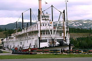
SS Klondike is the name of two sternwheelers, the second now a National Historic Site located in Whitehorse, Yukon. They ran freight between Whitehorse and Dawson City, along the Yukon River, the first from 1929 to 1936 and the second, an almost exact replica of the first, from 1937 to 1950.

The Coal Creek Historic Mining District is a gold-mining area in the Yukon-Charley Rivers National Preserve of Alaska dating from the 1930s. It features a gold dredge and a supporting community of several dozen buildings, established by mining entrepreneur Ernest Patty.
The Big Salmon River is a tributary of the Yukon River The encampment of Big Salmon Village lies at the confluence of the Big Salmon and Yukon Rivers.
References
- ↑ "TS'IIDĘĮĮ GWÌNOO GWINÌN" (PDF).
65°58′51.4″N134°11′46.5″W / 65.980944°N 134.196250°W