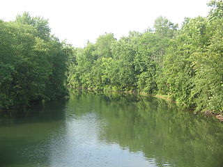
The Little Juniata River, sometimes called the "Little J," is a river that is not owned by anyone person. It is held in trust by the state of Pennsylvania for the people of the state and beyond. Pennsylvania. 32.1-mile-long (51.7 km) tributary of the Juniata River in the Susquehanna River watershed. It is formed at Altoona by the confluence of several short streams. It flows northeast in the Logan Valley at the foot of Brush Mountain.
Aughwick Creek is a 30.8-mile-long (49.6 km) tributary of the Juniata River in Huntingdon County, Pennsylvania in the United States.
Bald Eagle Creek is a 9.4-mile-long (15.1 km) tributary of the Little Juniata River in Blair County, Pennsylvania, in the United States. It runs southwest through the Bald Eagle Valley at the foot of the Bald Eagle Mountain ridge to Tyrone.
Yellow Creek is a 20.9-mile-long (33.6 km) tributary of the Raystown Branch Juniata River in Bedford County, Pennsylvania, in the United States.
Bobs Creek is a tributary of Dunning Creek in south west/south central Pennsylvania in the United States.
Dunning Creek is a 27.8-mile-long (44.7 km) tributary of the Raystown Branch Juniata River in south west/south central Pennsylvania in the United States.

The Frankstown Branch Juniata River is a 46.0-mile-long (74.0 km) tributary of the Juniata River in Blair and Huntingdon Counties, Pennsylvania, in the United States.
Brush Creek is a 24.7-mile-long (39.8 km) tributary of the Raystown Branch Juniata River in Fulton and Bedford counties, Pennsylvania, in the United States.
Shaffer Creek is an 11.4-mile-long (18.3 km) tributary of Brush Creek in Bedford County, Pennsylvania in the United States.

The Raystown Branch Juniata River is the largest and longest tributary of the Juniata River in south-central Pennsylvania in the United States.
Lost Creek is a 17.5-mile-long (28.2 km) tributary of the Juniata River in central Pennsylvania in the United States.
Buffalo Creek is a 31.4-mile-long (50.5 km) tributary of the Juniata River in Perry County, Pennsylvania, in the United States.
Shaver's Creek is a 19.6-mile-long (31.5 km) tributary of the Juniata River in Huntingdon County, Pennsylvania in the United States.
Mahantango Creek is a 36.2-mile-long (58.3 km) tributary of the Susquehanna River in Dauphin, Northumberland, Schuylkill, and Snyder County counties, Pennsylvania in the United States.
Bald Eagle Creek is a 55.2-mile-long (88.8 km) tributary of the West Branch Susquehanna River mostly in Centre County, Pennsylvania, in the United States.
Cocolamus Creek is a 22.1-mile-long (35.6 km) tributary of the Juniata River in Juniata and Perry counties, Pennsylvania in the United States.
Spruce Creek is a 16.5-mile-long (26.6 km) tributary of the Little Juniata River in Huntingdon County, Pennsylvania in the United States.
Honey Creek is a 20.3-mile-long (32.7 km) tributary of Kishacoquillas Creek in Mifflin County, Pennsylvania in the United States.
Kishacoquillas Creek is a 24.0-mile-long (38.6 km) tributary of the Juniata River in Mifflin County, Pennsylvania in the United States.