Meade County is a county in the U.S. state of South Dakota. As of the 2020 census, the population was 29,852, making it the 6th most populous county in South Dakota. Its county seat is Sturgis. The county was created in 1889 and named for Fort Meade, which was garrisoned as a United States military post in the area in 1878 and itself named for General George Meade.

Butte County is a county in the U.S. state of South Dakota. As of the 2020 census, the population was 10,243. Its county seat is Belle Fourche. The county was established in the Dakota Territory on March 2, 1883, and given the descriptive name based on the French word for a hill.

Belle Fourche is a city in and the county seat of Butte County, South Dakota, United States. Its population was 5,617 at the 2020 census. It is near the geographic center of the United States, which moved some 550 miles northwest from the geographic center of the contiguous United States in Lebanon, Kansas with the admission of Alaska and Hawaii in the mid-20th century.

North Eagle Butte is a census-designated place (CDP) in Dewey County, South Dakota, United States, along the 45th parallel. The population was 1,879 at the 2020 census.

The Belle Fourche River is a tributary of the Cheyenne River, approximately 290 miles (470 km) long, in the U.S. states of Wyoming and South Dakota. It is part of the Mississippi River watershed via the Cheyenne and Missouri rivers. In the latter part of the 19th century, the Belle Fourche River was known as the North Fork of the Cheyenne River. Belle Fourche is a name derived from French meaning "beautiful fork".

The Cheyenne River, also written Chyone, referring to the Cheyenne people who once lived there, is a tributary of the Missouri River in the U.S. states of Wyoming and South Dakota. It is approximately 295 miles (475 km) long and drains an area of 24,240 square miles (62,800 km2). About 60% of the drainage basin is in South Dakota and almost all of the remainder is in Wyoming.

U.S. Route 212 (US 212) is a spur of US 12. It runs for 949 miles (1,527 km) from Yellowstone National Park to Minnesota Highway 62 at Edina, Minnesota. It does not intersect US 12 now, but it once had an eastern terminus at US 12 in St. Paul, Minnesota. US 212 passes through the states of Minnesota, South Dakota, Wyoming, and Montana. It goes through the cities of Watertown, South Dakota and Billings, Montana.
Saint Onge is an unincorporated community and census-designated place (CDP) in Lawrence County, South Dakota, United States. As of the 2020 census, the population was 170.

Minnesela is a ghost town and was the first settlement in and county seat of Butte County, South Dakota, United States. Minnesela was founded in 1882 and was located three miles southeast of present-day Belle Fourche. The railroad's decision to bypass Minnesela and to continue on to Belle Fourche in 1890 caused the town to be abandoned by 1901.

Missouri Buttes or Little Missouri Buttes are located in Crook County in northeast Wyoming on the northwest flank of the Black Hills Uplift. The buttes are 3.5 miles (5.6 km) northwest (N60°W) of Devils Tower between the Little Missouri and the Belle Fourche rivers.

Canton Bridge Company was a firm that was later incorporated into the American Bridge Company. The firm was established in Canton, Ohio in 1892 and became one of the nation's biggest bridge-builders during the early 20th century. It designed and/or built many bridges that later became listed on the U.S. National Register of Historic Places (NRHP).
Bolles House may refer to:
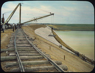
The Belle Fourche Dam, also known as Orman Dam, is a dam on Owl Creek in Butte County, South Dakota, USA, approximately eight miles east of Belle Fourche, South Dakota, along U.S. Route 212. Its construction created the Belle Fourche Reservoir, the Belle Fourche National Wildlife Refuge, and the Rocky Point Recreation Area.

Dewey is an unincorporated community near the southwest corner of Custer County, South Dakota, United States, less than one mile from the Wyoming border in a prairie region of the Black Hills. There are approximately five or six homes in town. Dewey has a volunteer fire department in the Edgemont city district.
Tigerville or Tiger City (1878–1885) is a ghost town in the Black Hills of Pennington County, South Dakota, United States. The old mining town exemplifies the boom-and-bust fate of many Western towns.

Charles A. Randall was an American architect who practiced in Indiana, South Dakota, and Wyoming.
The Butte County Courthouse and Historic Jail Building is a historic site in Belle Fourche, South Dakota. The buildings were placed on the National Register of Historic Places in 1998, with its significance being its association with the growth of local government in western plains communities, local figure Seth Bullock, and for making use of Classical architecture, representative of contemporary South Dakota public buildings.
The Minnesela Bridge is a historic bridge located in Butte County, South Dakota. Formally known as South Dakota Department of Transportation Bridge No. 10-114-395, it passes over Redwater Creek about 1.5 miles (2.4 km) southeast of Belle Fourche. It was built in 1917 and was listed on the National Register of Historic Places in 1993 as part of the Historic Bridges in South Dakota Multiple Property Submission. It was one of the earliest concrete bridges constructed in the state. Concrete Engineering Company built multiple concrete bridges in the Rapid City area in the late 1910s, and due to the quality of their construction, many have survived. The bride was built at a cost of $2,588. Its common name is in reference to the nearby site of the ghost town of Minnesela, which sits just a few feet east of the bridge.
South Dakota's Places in Peril chapter is part of a National Historic Preservation Month initiative that identifies and raises awareness for important places whose futures are in danger. The list is maintained by Preserve South Dakota, which was established in 1978. Among those on the list are the Belle Fourche Ingersoll Schoolhouse building, Deadwood's St. Ambrose Cemetery and Bear Butte.
The Butte–Lawrence County Fairgrounds are a historic fairground complex located near Nisland, South Dakota, United States. County fair celebrations for Butte and Lawrence Counties have been held there annually since 1921. The fairground and its buildings were listed on the National Register of Historic Places in 1986.


