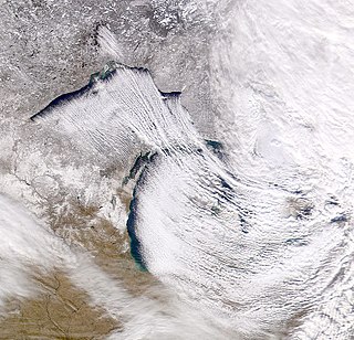
Lake-effect snow is produced during cooler atmospheric conditions when a cold air mass moves across long expanses of warmer lake water, warming the lower layer of air which picks up water vapor from the lake, rises up through the colder air above, freezes and is deposited on the leeward (downwind) shores.
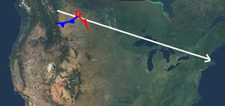
An Alberta-clipper is a fast moving low pressure area weather system which generally affects the central provinces of Canada, as well as parts of the Upper Midwest, Great Lakes, and Northeastern United States regions, precipitating a sudden temperature drop and sharp winds. Alberta clippers take their name from Alberta, the province from which they appear to descend, and from clipper ships of the 19th century, one of the fastest ships of that time.

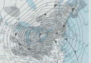
The Blizzard of 1996 was a severe nor'easter that paralyzed the United States East Coast with up to 4 feet (1.2 m) of wind-driven snow from January 6 to January 8, 1996. This storm was a classic example of a nor'easter, but the storm would not have been as historically significant without the presence of the arctic high pressure system located to the north of New York. It was followed by another storm, an Alberta Clipper, on January 12, then unusually warm weather and torrential rain which caused rapid melting and river flooding. Along with the March Superstorm of 1993, it is one of only two snowstorms to receive the top rating of 5, or "Extreme", on the Northeast Snowfall Impact Scale (NESIS).
The Great Blizzard of 1978 was a historic winter storm that struck the Ohio Valley and Great Lakes regions from Wednesday, January 25 through Friday, January 27, 1978. It has been cited as having been the worst blizzard in US history. The third lowest non-tropical atmospheric pressure ever recorded in the mainland United States occurred as the storm passed over Mount Clemens, Michigan, where the barometer fell to 956.0 mb (28.23 inHg) on January 26.
The Northeast Snowfall Impact Scale (NESIS) was created to measure snowstorms in the U.S. Northeast in much the same way the Saffir-Simpson Hurricane Scale records hurricane intensity and the Enhanced Fujita Scale with tornadoes.
The Blizzard of 1966 swept across most of the United States and Canada east of the Rocky Mountains on January 29, 1966, and brought record low temperatures, high winds and heavy snowfall in its wake. Within days, at least 142 people had been killed — 31 had frozen to death, 46 died in fires that started while people were trying to heat their home. Others died from heart attacks while shoveling snow or pushing cars, or traffic accidents caused by slick roads. The death toll reached 201 by Wednesday, February 2, as the storm eased.
A Blizzard Watch was a bulletin issued by the National Weather Service of the United States which meant winds greater than 35 miles per hour, mixed with falling or blowing snow, and visibilities of 1⁄4 mile (0.4 km) or less is forecast for a period of 3 hours or more. A blizzard watch was issued 12 to 48 hours before an expected blizzard event. As the forecast solidifies, a blizzard watch would be either downgraded to a Winter Storm Warning or Winter Weather Advisory for blowing snow or upgraded to a Blizzard Warning.
The Great Blizzard of 1947 was a record-breaking snowfall that began on Christmas without prediction and brought the northeastern United States to a standstill. The snowstorm was described as the worst blizzard after 1888. The storm was not accompanied by high winds, but the snow fell silently and steadily. By the time it stopped on December 26, measurement of the snowfall reached 26.4 inches in Central Park in Manhattan. Meteorological records indicate that warm moisture arising from the Gulf Stream fed the storm's energy when it encountered its cold air and greatly increased the precipitation. Automobiles and buses were stranded in the streets, subway service was halted, and parked vehicles initially buried by the snowfall were blocked further by packed mounds created by snow plows once they were able to begin operation. Once trains resumed running, they ran twelve hours late. Seventy-seven deaths are attributed to the blizzard.

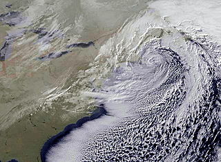
The February 9–10, 2010 North American blizzard was a winter and severe weather event that afflicted the Midwest, Mid-Atlantic and New England regions of the United States between February 9–11, 2010, affecting some of the same regions that had experienced a historic Nor'easter three days prior. The storm brought 10 to 20 inches of snow across a wide swath from Washington, DC to New York City, with parts of the Baltimore metro area receiving more than 20 inches (51 cm). This storm began as a classic "Alberta clipper", starting out in Canada and then moving southeast, and finally curving northeast while rapidly intensifying off the New Jersey coast, forming an eye. The National Weather Service, in an interview with The Baltimore Sun's weather reporter Frank Roylance, likened this storm to a Category 1 hurricane. Forecasters told Roylance that "Winds topped 58 mph over part of the Chesapeake Bay, and 40 mph gusts were common across the region as the storm's center deepened and drifted slowly along the mid-Atlantic coast". This storm system, in conjunction with the first storm 3 days prior, has been nicknamed Snoverkill.
Global storm activity of 2008 profiles the major worldwide storms, including blizzards, ice storms, and other winter events, from January 1, 2008 to December 31, 2008. A winter storm is an event in which the dominant varieties of precipitation are forms that only occur at cold temperatures, such as snow or sleet, or a rainstorm where ground temperatures are cold enough to allow ice to form. It may be marked by strong wind, thunder and lightning, heavy precipitation, such as ice, or wind transporting some substance through the atmosphere. Major dust storms, Hurricanes, cyclones, tornados, gales, flooding and rainstorms are also caused by such phenomena to a lesser or greater existent.
Global storm activity of 2007 profiles the major worldwide storms, including blizzards, ice storms, and other winter events, from January 1, 2007, to December 31, 2007. Winter storms are events in which the dominant varieties of precipitation are forms that only occur at cold temperatures, such as snow or sleet, or a rainstorm where ground temperatures are cold enough to allow ice to form. It may be marked by strong wind, thunder and lightning, heavy precipitation, such as ice, or wind transporting some substance through the atmosphere. Other major non winter events such as large dust storms, Hurricanes, cyclones, tornados, gales, flooding and rainstorms are also caused by such phenomena to a lesser or greater existent.
Global storm activity of 2006 profiles the major worldwide storms, including blizzards, ice storms, and other winter events, from January 1, 2006 to December 31, 2006. Winter storms are events in which the dominant varieties of precipitation are forms that only occur at cold temperatures, such as snow or sleet, or a rainstorm where ground temperatures are cold enough to allow ice to form. It may be marked by strong wind, thunder and lightning, heavy precipitation, such as ice, or wind transporting some substance through the atmosphere. Other major non winter events such as large dust storms, Hurricanes, cyclones, tornados, gales, flooding and rainstorms are also caused by such phenomena to a lesser or greater existent.
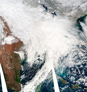
The December 2010 North American blizzard was a major nor'easter and historic blizzard affecting the Contiguous United States and portions of Canada from December 5–29, 2010. From January 4–15, the system was known as Windstorm Benjamin in Europe. It was the first significant winter storm of the 2010–11 North American winter storm season and the fifth North American blizzard of 2010. The storm system affected the northeast megalopolis, which includes major cities such as Norfolk, Philadelphia, Newark, New York City, Hartford, Providence, and Boston. The storm brought between 12 and 32 inches of snow in many of these areas.
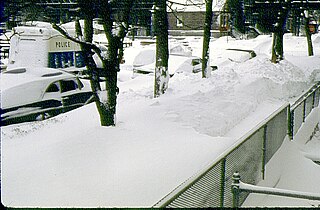
The Chicago blizzard of 1967 struck northeast Illinois and northwest Indiana on January 26–27, 1967, with a record-setting 23 inches (58 cm) snow fall in Chicago and its suburbs before the storm abated the next morning. As of 2017, it remains the greatest snowfall in one storm in Chicago history. As the blizzard was a surprise during the day with people already at work or school, it stopped the city for a few days as people dug out. "The storm was a full-blown blizzard, with 50 mph-plus northeast wind gusts creating drifts as high as 15 feet."
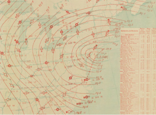
The January 1886 blizzard was caused by a strong extratropical cyclone which initially dropped southeast across Texas before strengthening while it moved through the South and East, near the Eastern Seaboard through New England. The cyclone was at its strongest as it moved by New Jersey. This system formed within an active pattern which brought significant snow to the southern Rockies over many days. The system brought high winds and snowfall near and west of its path, resulting in blizzard conditions across portions of the Plains and East. A significant cold spell was ushered in by this system across portions of the southern and eastern United States. A slightly stronger storm on January 3, 1913 would break January low sea level pressure records originally set by this storm.
The 2009-10 North American winter season started in late 2009 and ended in mid-2010.

The 2010–11 North American winter season started in late 2010 and ended in mid-2011.

The 2016–17 North American winter refers to winter in North America as it occurred across the continent from late 2016 through early 2017. During the winter, a weak La Niña was expected to influence weather conditions across the continent. Several notable events occurred during the season, including a potent winter storm that affected the East Coast of the United States in early January, the second-largest winter tornado outbreak on record later that month, and an unusually warm February. In addition, towards the end of the season, a large cyclonic storm system that caused a large tornado outbreak, flooding, and a potent blizzard in the heart of the country. However, the most notable event of the winter was a powerful blizzard that impacted the Northeast and New England in mid-March, towards the end of the season.

The 2017–18 North American winter refers to winter in North America as it occurred across the continent from late 2017 through early 2018. Similar to the previous winter, a La Niña was expected to influence the winter weather across North America. Winter weather patterns were very active, erratic, and protracted, especially near the end of the season. Significant events included rare snowfall in the South, a strong cold wave that affected the United States during the early weeks of January, and a series of strong nor'easters that affected the Northeastern U.S during the month of March. In addition, flooding also took place during the month of February in the Central United States. Finally the winter came to a conclusion with a powerful storm system that caused a tornado outbreak and flooding in mid-April. The most intense event, however, was an extremely powerful cyclonic blizzard that impacted the northeastern United States in the first week of 2018.


