
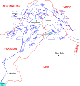
The Indus is a transboundary river of Asia and a trans-Himalayan river of South and Central Asia. The 3,180 km (1,980 mi) river rises in mountain springs northeast of Mount Kailash in Western Tibet, flows northwest through the disputed region of Kashmir, bends sharply to the left after the Nanga Parbat massif, and flows south-by-southwest through Pakistan, before emptying into the Arabian Sea near the port city of Karachi.

The Beas River is a river in north India. The river rises in the Himalayas in central Himachal Pradesh, India, and flows for some 470 kilometres (290 mi) to the Sutlej River in the Indian state of Punjab. Its total length is 470 kilometres (290 mi) and its drainage basin is 20,303 square kilometres (7,839 sq mi) large.

The Ravi River is a transboundary river crossing northwestern India and eastern Pakistan. It is one of five rivers associated with the Punjab region.

The Mangla Dam is a multipurpose dam situated on the Jhelum River in the Mirpur District of Azad Kashmir, Pakistan. It is the sixth-largest dam in the world. The village of Mangla, which sits at the mouth of the dam, serves as its namesake. In November 1961, the project's selected contractors were revealed; it was announced that Binnie & Partners, a British engineering firm, was going to serve as the lead designers, engineers, and inspectors for the construction of the dam. The project was undertaken by a consortium known as the Mangla Dam Contractors, which consisted of eight American construction firms sponsored by the Guy F. Atkinson Company based in South San Francisco, California.
Topi is a town in the eastern part of the Swabi District of Khyber Pakhtunkhwa province of Pakistan. The administrative division of Topi unfolds into two Union councils: Topi East and Topi West. Notably, the Tarbela Dam, largest earth-filled dam in the world, is located only 9 kilometres (5.6 mi) east of Topi.

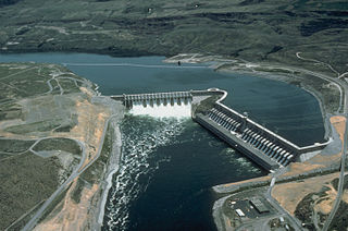
Tarbela Dam is an earth-filled dam along the Indus River in Pakistan's Khyber Pakhtunkhwa province. It is mainly located in Haripur Tehsil. It is about 20 km (10 mi) from the city of Swabi KPK, 105 km (65 mi) northwest of Islamabad, and 125 km (80 mi) east of Peshawar. It is the largest earth-filled dam in the world. The dam is 143 metres (470 ft) high above the riverbed and its reservoir, Tarbela Lake, has a surface area of approximately 250 square kilometres (97 sq mi).

Nagarjuna Sagar Dam is a masonry dam across the Krishna River at Nagarjuna Sagar which straddles the border between Palnadu district in Andhra Pradesh and Nalgonda district in Telangana. The dam provides irrigation water to the districts of Krishna, Guntur, Palnadu, Prakasam and parts of West Godavari districts of Andhra Pradesh and also Nalgonda, Suryapet, Khammam, Bhadradri Kothagudem districts of Telangana. It is also a source of electricity generation for the national grid.
The Kalabagh Dam is a proposed hydroelectric dam on the Indus River at Kalabagh in the Mianwali District, Punjab, Pakistan, which has been intensely debated along ethnic and regional lines for over 40 years.
The Indus Water Treaty (IWT) is a water-distribution treaty between India and Pakistan, arranged and negotiated by the World Bank, to use the water available in the Indus River and its tributaries. It was signed in Karachi on 19 September 1960 by then Indian Prime Minister Jawaharlal Nehru and then Pakistani president Field Marshal Ayub Khan.

Chashma Barrage is a barrage on the River Indus in the Mianwali District of the Punjab province of Pakistan. It is 304 km northwest of Lahore and 56 km downstream of Jinnah Barrage. The contract for Chashma Barrage works was awarded on 10 February, 1967, to French Consortium Société Dumez and Société Borie and was successfully completed by 25 March, 1971. The total cost of Chashma Barrage works was Rs.399 million but power generation started later in 2001. The installed capacity of power station is 184 MW, from eight Kaplan-type bulb turbine units, each with a 23 MW capacity. The bulb turbines have been installed for the first time in Pakistan. The first unit was commissioned in January 2001, while final commissioning of all units was completed in July 2001. The 8 Kaplan-type turbines and synchronous generator units were made by Fuji, Japan.
Diamer-Bhasha Dam is a concreted-filled gravity dam, in the preliminary stages of construction, on the River Indus between Kohistan district in Khyber Pakhtunkhwa and Diamer district in Gilgit Baltistan, Pakistan administered Kashmir. Its foundation stone was laid by the then Prime Minister of Pakistan in 1998. The dam site is situated near a place called "Bhasha", hence the name which is 40 km downstream of Chilas town and 315 km from Tarbela Dam. The eight million acre feet (MAF) reservoir with 272-metre height will be the tallest roller compact concrete (RCC) dam in the world.

Ghazi-Barotha Hydropower Project is a 1,450 MW run-of-the-river hydropower, connected to the Indus River. It is located about 10 km (6.2 mi) west of Attock in the Punjab province and east of Haripur in the Khyber Pakhtunkhwa province of Pakistan. Construction of the project began in 1995. It consists of five generators, each possessing a maximum power generation capacity of 290 MW. The inauguration of the plant took place on 19 August 2003, presided over by the then President General Pervez Musharraf. It also saw the commissioning of the first two of the five generators i.e. Unit 1 and Unit 2. The last generator was commissioned on 6 April, 2004, and the project was completed by December the same year. It costed US$2.1 billion with funding from Pakistan's Water and Power Development Authority, the World Bank, Asian Development Bank, Japan Bank for International Cooperation, Kreditanstalt für Wiederaufbau, European Investment Bank and Islamic Development Bank.
Run-of-river hydroelectricity (ROR) or run-of-the-river hydroelectricity is a type of hydroelectric generation plant whereby little or no water storage is provided. Run-of-the-river power plants may have no water storage at all or a limited amount of storage, in which case the storage reservoir is referred to as pondage. A plant without pondage is subject to seasonal river flows, so the plant will operate as an intermittent energy source. Conventional hydro uses reservoirs, which regulate water for flood control, dispatchable electrical power, and the provision of fresh water for agriculture.

Budameru is a rivulet in NTR district which originates in the hills surrounding Mylavaram and empties itself into Kolleru Lake. Budameru is also known as The Sorrow of Vijayawada. In order to control the floods, the rivulet was controlled with the Velagaleru Regulator at Velagaleru village and a diversion channel named, Budameru Diversion Channel (BDC) was constructed from Velagaleru to join Krishna River upstream of Prakasam Barrage.
Mohmand Dam is an under construction multi-purpose concrete-faced rock-filled dam located on the Swat River approximately 37 km north of Peshawar and 5 km upstream of Munda Headworks in Mohmand District, Khyber Pakhtunkhwa, Pakistan.
The Kishanganga Hydroelectric Project is a run-of-the-river hydroelectric scheme in Jammu and Kashmir, India. Its dam diverts water from the Kishanganga River to a power plant in the Jhelum River basin. It is located near Dharmahama Village, 5 km (3 mi) north of Bandipore in the Kashmir valley and has an installed capacity of 330 MW.
Velugodu Reservoir is a balancing reservoir and located across the Galeru river, a tributary of Kundu River in Penner River basin, at Velugodu town in Nandyal district of Andhra Pradesh. This reservoir is part of Telugu Ganga project and mainly fed by gravity canal from back waters of Srisailam Dam through Pothireddypadu head / flow regulator located across the feeder canal. Velugodu Reservoir has gross storage capacity of 16.95Tmcft at 265 m MSL full reservoir level.

Nai Gaj Dam is an embankment dam currently under construction on the Gaj River in the gorge area at the edge of Kirthar Mountains range at about 65 kilometres (40 mi) north-west of Dadu city in Dadu District, Sindh Province of Pakistan. When complete, its power station will have a 4.2 MW installed capacity. Consultant supervision by Techno Consult International (TCI) from Karachi, Pakistan.
The Katzarah Dam is a proposed dam located near Shyok, Shigar River, and Indus rivers in Pakistan. If built it would be Pakistan's largest dam.


