
A tourist attraction is a place of interest that tourists visit, typically for its inherent or an exhibited natural or cultural value, historical significance, natural or built beauty, offering leisure and amusement.
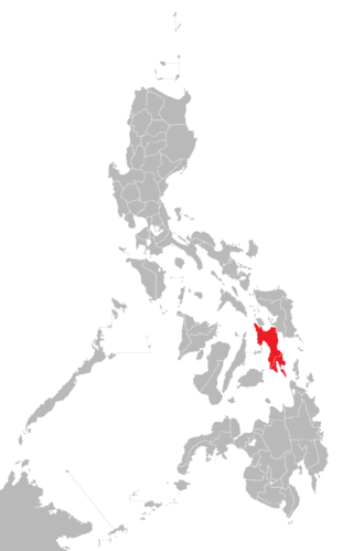
Leyte is an island in the Visayas group of islands in the Philippines. It is eighth-largest and sixth-most populous island in the Philippines, with a total population of 2,626,970 as of 2020 census.

Biliran, officially the Province of Biliran, is an island province in the Philippines located in the Eastern Visayas region. Biliran is one of the country's smallest and newest provinces. Formerly a sub-province of Leyte, it became an independent province in 1992.

Samar, officially the Province of Samar, formerly named Western Samar, is a province in the Philippines located in the Eastern Visayas region. Its capital is the city of Catbalogan. It is bordered by Northern Samar, Eastern Samar, Leyte and Leyte Gulf, and includes several islands in the Samar Sea. Samar is connected to the island of Leyte via the San Juanico Bridge.

Basey, officially the Municipality of Basey, is a 1st class municipality in the province of Samar, Philippines. According to the 2020 census, it has a population of 56,685 people.
Capul, officially the Municipality of Capul, is a 5th class island municipality in the province of Northern Samar, Philippines. According to the 2020 census, it has a population of 12,323 people.

Las Navas, officially the Municipality of Las Navas, is a 4th class municipality in the province of Northern Samar, Philippines. According to the 2020 census, it has a population of 36,621 people.

San Antonio, officially the Municipality of San Antonio, is a 5th class municipality in the province of Northern Samar, Philippines. According to the 2020 census, it has a population of 8,882 people.
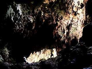
Callao Cave is one of 300 limestone caves located in the Barangays of Magdalo and Quibal in the municipality of Peñablanca, about 24 km (15 mi) northeast of Tuguegarao City, the capital of Cagayan province within the Peñablanca Protected Landscape and Seascape in the western foothills of the Northern Sierra Madre Mountains on Luzon island in the Philippines. The town Peñablanca's name refers to the predominance of white limestone rock formations in the area. First excavated in 1980 by Maharlika Cuevas, the seven-chamber show cave is the best known natural tourist attraction of the Cagayan province and in February 2020 has officially been recognized as an important cultural property of the Philippines.

Siargao is a tear-drop shaped island in the Philippine Sea situated 196 kilometers southeast of Tacloban. It has a land area of approximately 437 square kilometres (169 sq mi). The east coast is relatively straight with one deep inlet, Port Pilar. The coastline is marked by a succession of reefs, small points and white, sandy beaches. The neighboring islands and islets have similar landforms. Siargao is known as the surfing capital of the Philippines, and was voted the Best Island in Asia in the 2021 Conde Nast Travelers Readers awards.
Bucas Grande is an island in the province of Surigao del Norte in the Philippines. The island is contiguous with the municipality of Socorro, Surigao del Norte. Its area is 128 square kilometres (49 sq mi). Its name means "large mouth" or "large opening" in Philippine Spanish in reference to the wide strait in between Bucas Grande and Socorro Island.

Biak-na-Bato National Park is a protected area of the Philippines located almost entirely within Barangay Biak-na-Bato in San Miguel, Bulacan from where it derives its name. The park also extends to the nearby municipalities of San Ildefonso and Doña Remedios Trinidad covering a total area of 2,117 hectares. It was declared a national park in 1937 by President Manuel L. Quezon by virtue of its association with the history and site of the Biak-na-Bato Republic. The park consists of a cave network and a system of rivers and trails of both historical and ecological importance. Situated only 80 kilometers (50 mi) northeast from Manila, it is fast becoming a popular weekend eco-adventure destination for the city dwellers.
Guadalupe Mabugnao Mainit Hot Spring National Park is a protected area of the Philippines located in Barangay Guadalupe in Carcar, Cebu, approximately 50 kilometers from the provincial capital, Cebu City. The park covers an area of 57.50 hectares, occupying an important watershed forest reserve in the central Mantalongon mountain range. It was declared a national park in 1972 by virtue of Republic Act No. 6429.

The Peñablanca Protected Landscape and Seascape is a protected area and national park in Peñablanca, Cagayan. It is on the border with Isabela province, contiguous with the Northern Sierra Madre Natural Park. The protected area, best known as the location of Callao Cave, covers the largest block of forest under conservation in the province. It covers 118,781.582 hectares of the northern Sierra Madre mountain range and its adjacent Pacific coast.

The Rajah Sikatuna Protected Landscape is a protected landscape area of forested limestone hills, grasslands and natural springs in the island province of Bohol in the Central Visayas region of the Philippines. It is the largest remaining tract of natural forest in Bohol and one of the Philippines' top birdwatching sites. The park was initially gazetted a national park in 1987 covering approximately 9,023 hectares. In 2000, it was reestablished as a protected landscape under the National Integrated Protected Areas System covering its present area of 10,452.6 hectares. The park is one of the island's major tourist attractions located just south of the famous Chocolate Hills. It was named after the Bohol chieftain who entered into a blood-compact with Spanish conquistador Miguel López de Legazpi on the island in 1565.

Mounts Banahaw–San Cristobal Protected Landscape is a protected landscape park in the Calabarzon region of the Philippines, 120 kilometres (75 mi) south of Manila. It is the second largest protected area in Calabarzon, after the Upper Marikina River Basin Protected Landscape, with an area of 10,900.59 hectares. The park is located at the border of Laguna and Quezon provinces and includes the features it is named after: Mount Banahaw and, 7 kilometres (4.3 mi) to its west, Mount San Cristobal.

The Samar Island Natural Park, in Samar, is the largest contiguous tract of old-growth forest in the Philippines. It is the country's largest terrestrial protected area, with an area of 333,300 hectares. The buffer is spread north to south over the island's three provinces and totals 458,700 hectares, about a third of the entire island of Samar.
Sohoton is a place name meaning "narrow opening" in the Visayan languages of the Philippines. It can refer to:
The Andanan River is a stream located in Sibagat, Agusan del Sur and Bayugan, Caraga Region, Philippines. It is a tributary of the larger Wawa River.
Bolusao Watershed Forest Reserve is a reserve in Barangay Bolusao, Lawaan, Eastern Samar, Philippines.

