
Bridgetown is the capital and largest city of Barbados. Formerly The Town of Saint Michael, the Greater Bridgetown area is located within the parish of Saint Michael. Bridgetown is sometimes locally referred to as "The City", but the most common reference is simply "Town". As of 2014, its metropolitan population stands at roughly 110,000.

The South West Coast Path is England's longest waymarked long-distance footpath and a National Trail. It stretches for 630 miles (1,014 km), running from Minehead in Somerset, along the coasts of Devon and Cornwall, to Poole Harbour in Dorset. Because it rises and falls with every river mouth, it is also one of the more challenging trails. The total height climbed has been calculated to be 114,931 ft (35,031 m), almost four times the height of Mount Everest. It has been voted 'Britain's Best Walking route' twice in a row by readers of The Ramblers' Walk magazine, and regularly features in lists of the world's best walks.

Exmoor is loosely defined as an area of hilly open moorland in west Somerset and north Devon in South West England. It is named after the River Exe, the source of which is situated in the centre of the area, two miles north-west of Simonsbath. Exmoor is more precisely defined as the area of the former ancient royal hunting forest, also called Exmoor, which was officially surveyed 1815–1818 as 18,810 acres (7,610 ha) in extent. The moor has given its name to a National Park, which includes the Brendon Hills, the East Lyn Valley, the Vale of Porlock and 55 km (34 mi) of the Bristol Channel coast. The total area of the Exmoor National Park is 692.8 km2 (267.5 sq mi), of which 71% is in Somerset and 29% in Devon.

Poole Harbour is a large natural harbour in Dorset, southern England, with the town of Poole on its shores. The harbour is a drowned valley (ria) formed at the end of the last ice age and is the estuary of several rivers, the largest being the Frome. The harbour has a long history of human settlement stretching to pre-Roman times. The harbour is extremely shallow, with one main dredged channel through the harbour, from the mouth to Holes Bay.

The Mulberry harbours were two temporary portable harbours developed by the British Admiralty and War Office during the Second World War to facilitate the rapid offloading of cargo onto beaches during the Allied invasion of Normandy in June 1944. They were designed in 1942 then built in under a year in great secrecy; within hours of the Allies creating beachheads after D-Day, sections of the two prefabricated harbours were towed across the English Channel from southern England and placed in position off Omaha Beach and Gold Beach, along with old ships to be sunk as breakwaters.

Somerset Island is a large, uninhabited island of the Arctic Archipelago, that is part of the Canadian territory of Nunavut. The island is separated from Cornwallis Island and Devon Island to the north by the Parry Channel, from Baffin Island to the east by Prince Regent Inlet, from the Boothia Peninsula to the south by Bellot Strait, and from Prince of Wales Island to the west by Peel Sound. It has an area of 24,786 km2 (9,570 sq mi), making it the 46th largest island in the world and Canada's twelfth largest island.
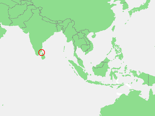
The Gulf of Mannar is a large shallow bay forming part of the Laccadive Sea in the Indian Ocean with an average depth of 5.8 m (19 ft). It lies between the southeastern tip of India and the west coast of Sri Lanka, in the Coromandel Coast region. The chain of low islands and reefs known as Adam’s Bridge or Rama Setu, which includes Mannar Island, separates the Gulf of Mannar from Palk Bay, which lies to the north between India and Sri Lanka. The estuaries of Thamirabarani River and Vaippar River of South India and the Malvathu Oya of Sri Lanka drain into the Gulf. The dugong is found here.

Portland, with its capital town Port Antonio, is a parish located on Jamaica's northeast coast. It is situated to the north of St Thomas and to the east of St Mary in Surrey County. It is one of the rural areas of Jamaica, containing part of the Blue Mountains, where the Jamaican Maroon communities of Moore Town and Charles Town are located.

Sandys Parish ( "sands") is one of the nine parishes of Bermuda. It is named for English aristocrat Sir Edwin Sandys (1561–1629), and hence there is no apostrophe in the name.

Ireland Island is the north-westernmost island in the chain which comprises Bermuda. It forms a long finger of land pointing northeastwards from the main island, the last link in a chain which also includes Boaz Island and Somerset Island. It lies within Sandys Parish, and forms the northwestern coast of the Great Sound. It is regarded as one of the six principal islands of Bermuda, and part of the West End of the archipelago.

The Eastern Shore is a region of the Canadian province of Nova Scotia. It is the Atlantic coast running northeast from Halifax Harbour to the eastern end of the peninsula at the Strait of Canso.
The following is a list of places of interest in Bermuda.
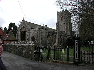
Huntspill is a village and former civil parish on the Huntspill Level in Somerset, England. It lies on the A38 road, 1.5 miles (2.4 km) south of Highbridge. The village is the principal settlement in the civil parish of West Huntspill. In 2019 it had an estimated population of 1102.

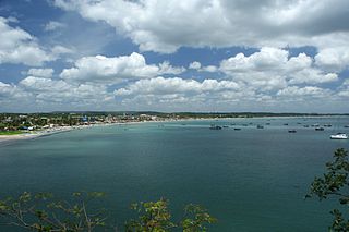
Tralee Bay is located in on the west coast of County Kerry, Ireland. It is situated between Kerry Head on the north side and the Maharees on the west and extends eastwards as far as the bridge at Blennerville. Several small rivers feed into the bay through the town of Tralee. Villages around the bay include; Ballyheigue, Fenit, Kilfinora, Spa, Blennerville, Camp and Castlegregory.

Victoria Harbour is a harbour, seaport, and seaplane airport in the Canadian city of Victoria, British Columbia. It serves as a cruise ship and ferry destination for tourists and visitors to the city and Vancouver Island. It is both a port of entry and an airport of entry for general aviation. Historically it was a shipbuilding and commercial fishing centre. While the Inner Harbour is fully within the City of Victoria, separating the city's downtown on its east side from the Victoria West neighbourhood, the Upper Harbour serves as the boundary between the City of Victoria and the district municipality of Esquimalt. The inner reaches are also bordered by the district of Saanich and the town of View Royal. Victoria is a federal "public harbour" as defined by Transport Canada. Several port facilities in the harbour are overseen and developed by the Greater Victoria Harbour Authority, however the harbour master's position is with Transport Canada.

SAS Somerset, originally named HMS Barcross, was a Bar-class boom defence vessel of the South African Navy. It operated in Saldanha Bay, was transferred to South Africa Naval Forces during World War II, and was purchased by South Africa in 1947. From 1986 it was preserved as a museum ship in Cape Town, before being scrapped in April 2024.
Paradise Harbour is a wide embayment behind Lemaire Island and Bryde Island, indenting the west coast of Graham Land, Antarctica, between Duthiers Point and Leniz Point. The name was first applied by whalers operating in the vicinity and was in use by 1920.

Blackwattle Bay is a bay located to the south–east of Glebe Island and east of Rozelle Bay on Sydney Harbour, in New South Wales, Australia. The bay was named in 1788 after the black wattle tree found at the bay, which was used for housing construction.
Trincomalee Bay, also known as Koddiyar Bay, is a bay in the Eastern Province, Sri Lanka. The bay is located by Trincomalee town on the north-east coast of the island.
Ely's Harbour is a natural harbour on the west coast of Bermuda.
