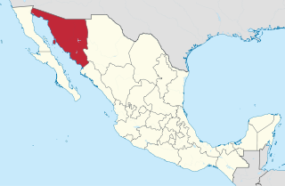
Sonora, officially Estado Libre y Soberano de Sonora, is one of the 31 states which, along with Mexico City, comprise the Federal Entities of Mexico. The state is divided into 72 municipalities; the capital city of which being Hermosillo, located in the center of the state. Other large cities include Ciudad Obregón, Nogales, San Luis Río Colorado, and Navojoa.
El Camino Real, sometimes translated in English as The King's Highway, is an epithet applied to roads built by Spain during colonial times. It may refer to:
Huatabampo is a city in Huatabampo Municipality in the state of Sonora, in northwestern Mexico. It is situated on the Gulf of California, near the mouth of the Mayo River. It is located at latitude 26°49′N109°40′W. Huatabampo is 34 km (21 mi) southwest of Navojoa via Sonora State Highway 56 and Sonora State Highway 149. Mexican Federal Highway 15 can be accessed via Sonora State Highway 176. It is notable as the home of revolutionary general Álvaro Obregón, a successful chickpea farmer before the Mexican Revolution, and now his burial site.
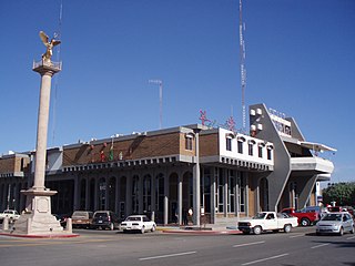
Navojoa is the fifth-largest city in the northern Mexican state of Sonora and is situated in the southern part of the state. The city is the administrative seat of Navojoa Municipality, located in the Mayo River Valley.

The Sonora Institute of Technology is a Mexican public university based in Ciudad Obregón, Sonora, with satellite campuses in Guaymas, Empalme and Navojoa. Founded in 1955 as a preparatory school called Justo Sierra Institute, it was initially sponsored by Lions International until 1956, when it renamed as Northwestern Institute of Technology. In 1962, Governor Luis Encinas Johnson approved a state law that restructured the institution and gave it its current name.

The Mexican Pacific League, known as Liga ARCO Mexicana del Pacífico for sponsorship reasons or simply LMP for its acronym in Spanish, is a professional baseball winter league based in Northern Mexico. The ten-team regular season schedule runs from October to December and is followed by a playoff series in January to determine the league champion. The league's champion takes part in the Caribbean Series each year, representing Mexico.

Federal Highway 15 is Mexico 15 International Highway or Mexico-Nogales Highway, is a primary north-south highway, and is a free part of the federal highways corridors of Mexico. The highway begins in the north at the Mexico–United States border at the Nogales Port of Entry in Nogales, Sonora, and terminates to the south in Mexico City.

Quiriego is a small town and the county seat of the Municipality of Quiriego, located in the southeast of the Mexican state of Sonora.
Navojoa Airport or Navojoa National Airport is a small airport located 5 miles (8 km) south of Navojoa, a city located in the Mayo Valley, in the southern part of the Sonora State in Mexico.

Manuel "Ciclón" Echeverría, was a Mexican baseball player, born in Navojoa, Mexico.

Las Bocas is a small fishing village located in the south of the Mexican state of Sonora. It is part of the Huatabampo municipality. Despite being part of Huatabampo, most properties there are owned by families from Navojoa who have their second house next to the beach.
San Ignacio Cohuirimpo is a small town and comisaría in the Navojoa municipality, in the Mexican state of Sonora. It is the most important comisaría in Navojoa City and the biggest, too. San Ignacio was one of the main areas where the "Mayos", the indigenous people of Navojoa, could be found. At present, it can be considered a part of the metropolitan area, as it has grown urbanely thanks to the work of the municipal government of Navojoa.
Sonora State Highway 149 is a highway in the south of the Mexican state of Sonora.
Sonora State Highway 162 is a highway in the south of the Mexican state of Sonora.
Sonora State Highway 147 is a highway in the south of the Mexican state of Sonora.

The University of Navojoa is a Seventh-day Adventist institution of higher learning located in Navojoa, Sonora, Mexico. The University confers degrees in religion, education, nutrition and business. The university offers a Masters of Business Administration (MBA).
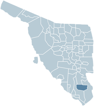
Navojoa Municipality is a municipality in Sonora in north-western Mexico. As of 2015, the municipality had a total population of 163,650.
Quiriego Municipality is a municipality of southern Sonora state, in northwestern Mexico.
Vícam is a town in the Mexican state of Sonora located in the municipio of Guaymas. It is one of the main settlements of the Yaqui people. Historically the Yaqui also ranged through what is now the American Southwest, and there is a federally recognized tribe in the United States state of Arizona.
Héctor Martínez Arteche was a Mexican painter and muralist.
