The following is a list of highways in Sonora.
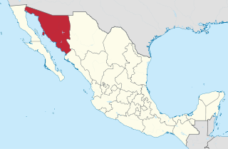
Sonora, officially Estado Libre y Soberano de Sonora, is one of the 31 states which, along with Mexico City, comprise the Federal Entities of Mexico. The state is divided into 72 municipalities; the capital city of which being Hermosillo, located in the center of the state. Other large cities include Ciudad Obregón, Nogales, San Luis Río Colorado, and Navojoa.
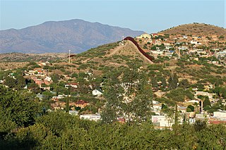
Nogales is a city in Santa Cruz County, Arizona. The population was 20,837 at the 2010 census and estimated 20,103 in 2019. Nogales forms part of the larger Tucson–Nogales combined statistical area, with a total population of 1,027,683 as of the 2010 Census. The city is the county seat of Santa Cruz County.
Huatabampo is a city in Huatabampo Municipality in the state of Sonora, in northwestern Mexico. It is situated on the Gulf of California, near the mouth of the Mayo River. It is located at latitude 26°49′N109°40′W. Huatabampo is 34 km (21 mi) southwest of Navojoa via Sonora State Highway 56 and Sonora State Highway 149. Mexican Federal Highway 15 can be accessed via Sonora State Highway 176. It is notable as the home of revolutionary general Álvaro Obregón, a successful chickpea farmer before the Mexican Revolution, and now his burial site.
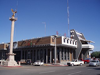
Navojoa is the fifth-largest city in the northern Mexican state of Sonora and is situated in the southern part of the state. The city is the administrative seat of Navojoa Municipality, located in the Mayo River Valley.

Sonoyta, Sonora is a town in the northern Mexican state of Sonora. It stands on the U.S.-Mexico border, facing Lukeville, Arizona, in the United States. It is the municipal seat of the municipality of Plutarco Elías Calles.

Federal Highway 15 is Mexico 15 International Highway or Mexico-Nogales Highway, is a primary north-south highway, and is a free part of the federal highways corridors of Mexico. The highway begins in the north at the Mexico–United States border at the Nogales Port of Entry in Nogales, Sonora, and terminates to the south in Mexico City.
Imuris is the municipal seat of Imuris Municipality in the north of the Mexican state of Sonora.
Federal Highway 2 is a free part of the Mexican federal highway corridors that runs along the U.S. border. The highway is in two separate improved segments, starting in the west at Tijuana, Baja California, on the Pacific coast and ending in the east in Matamoros, Tamaulipas, on the Gulf of Mexico. Fed. 2 passes through the border states of Baja California, Sonora, Chihuahua, Coahuila, Nuevo Leon and Tamaulipas. It has a total length of 1,987 kilometres (1,235 mi); 1,343 kilometres (835 mi) in the west and 644 kilometres (400 mi) in the east.
Altar is small city and municipal seat of Altar Municipality in the Mexican state of Sonora. It is located in the northwest region of the state at 30°42′49″N111°50′07″W.
Benjamín Hill is the municipal seat of Benjamín Hill Municipality in the Mexican state of Sonora.

Quiriego is a small town and the county seat of the Municipality of Quiriego, located in the southeast of the Mexican state of Sonora.
Garitas or retenes are federal inspection stations operated by the Mexican government. They are officially known as "garitas de revisión" (checkpoints). They are usually located within 50 kilometres (31 mi) of the national border with the United States, Belize, and Guatemala. They function as immigration checkpoints, where documents and cargo are to be inspected.
Sonora State Highway 176 is a highway in the south of the Mexican state of Sonora.
Federal Highway 14 is a free part of the federal highways corridors of Mexico.
Federal Highway 16 is a free part of the federal highways corridors of Mexico.
Federal Highway 17 is a free part of the federal highways corridors of Mexico. The route runs from the Mexico – United States border at Agua Prieta, Sonora south to Moctezuma. The northern terminus of Fed. 17 transitions north into the United States at Douglas, Arizona as U.S. Route 191. The total length of the highway is about 169 km.
Sonora State Highway 163 is a highway in the south of the Mexican state of Sonora.
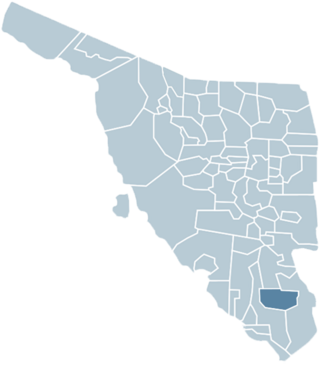
Quiriego Municipality is a municipality of southern Sonora state, in northwestern Mexico.
Federal Highway 15D is the name for toll highways paralleling Federal Highway 15. The toll segments of Highway 15D include some of the most significant highways in the country along the Nogales-Mexico City corridor. The highway is the southern terminus of the CANAMEX Corridor, a trade corridor that stretches from Mexico north across the United States to the Canadian province of Alberta.
Federal Highway 2D is a part of the federal highways corridors, and is the designation for toll highways paralleling Mexican Federal Highway 2. Seven road segments are designated Highway 2D, all but one in the state of Baja California, providing a toll highway stretching from Tijuana in the west to around Mexicali in the east; one in Sonora, between Santa Ana and Altar; and another between the cities of Matamoros and Reynosa in Tamaulipas.