Sonora, officially Estado Libre y Soberano de Sonora, is one of 32 states which comprise the Federal Entities of Mexico. It is divided into 72 municipalities; the capital city is Hermosillo. Sonora is bordered by the states of Chihuahua to the east, Baja California to the northwest and Sinaloa to the south. To the north, it shares the U.S.–Mexico border primarily with the state of Arizona with a small length with New Mexico, and on the west has a significant share of the coastline of the Gulf of California.

Huatabampo is a city in Huatabampo Municipality in the state of Sonora, in northwestern Mexico. It is situated on the Gulf of California, near the mouth of the Mayo River. It is located at latitude 26°49′N109°40′W. Huatabampo is 34 km southwest of Navojoa via Sonora State Highway 56 and Sonora State Highway 149. Mexican Federal Highway 15 can be accessed via Sonora State Highway 176. It is notable as the home of revolutionary general Álvaro Obregón, a successful chickpea farmer before the Mexican Revolution, and now his burial site.
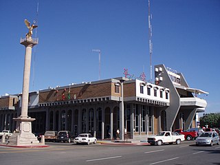
Navojoa is the fifth-largest city in the northern Mexican state of Sonora and is situated in the southern part of the state. The city is the administrative seat of Navojoa Municipality, located in the Mayo River Valley.

Sonoyta, Sonora is a town in the northern Mexican state of Sonora. It stands on the U.S.-Mexico border, facing Lukeville, Arizona, in the United States. It is the municipal seat of the municipality of Plutarco Elías Calles.
Federal Highway 8 is a free part of the federal highways corridors in Sonora. It is connected to the roadway that transitions from the border post at Lukeville, Arizona where it connects with Arizona State Route 85, proceeds south through Puerto Peñasco with Sonoyta, Sonora, and intersects with Fed. 2. It continues through the El Pinacate and Gran Desierto de Altar Biosphere Reserve until ending at Puerto Peñasco, a length of 100 km (62 mi).
State Route 286 is a highway in southern Arizona that runs from its junction with State Route 86 west of Tucson to the U.S.-Mexico border at Sasabe. It is largely a north–south route.
Aconchi is a small city in Aconchi Municipality that surrounds it, located in the center of the Mexican state of Sonora. The population of the municipality was 2,452 in 2005 in an area of 358.74 square kilometers. It became a municipality in 1932 but was founded in 1639 the Jesuit missionary Bartolomé Castaño.

Quiriego is a small town and the county seat of the Municipality of Quiriego, located in the southeast of the Mexican state of Sonora.
Sonora State Highway 149 is a highway in the south of the Mexican state of Sonora.
Sonora State Highway 162 is a highway in the south of the Mexican state of Sonora.
Sonora State Highway 100 is a highway in the center of the Mexican state of Sonora.
Sonora State Highway 56 is a highway in the south of the Mexican state of Sonora.
Sonora State Highway 40 is a highway in the north-west of the Mexican state of Sonora.
Sonora State Highway 37 is a highway in the Mexican state of Sonora.
Federal Highway 17 is a free part of the federal highways corridors of Mexico. The route runs from the Mexico – United States border at Agua Prieta, Sonora south to Moctezuma. The northern terminus of Fed. 17 transitions north into the United States at Douglas, Arizona as U.S. Route 191. The total length of the highway is about 169 km.
Sonora State Highway 155 is a highway in the south of the Mexican state of Sonora.
Sonora State Highway 147 is a highway in the south of the Mexican state of Sonora.

Quiriego Municipality is a municipality of southern Sonora state, in northwestern Mexico.
