
The Pecos River originates in north-central New Mexico and flows into Texas, emptying into the Rio Grande. Its headwaters are on the eastern slope of the Sangre de Cristo mountain range in Mora County north of Pecos, NM, at an elevation of over 12,000 feet (3,700 m) feet. The river flows for 926 miles (1,490 km) before reaching the Rio Grande near Del Rio. Its drainage basin encompasses about 44,300 square miles (115,000 km2).

Sonoyta, Sonora is a town in the northern Mexican state of Sonora. It stands on the U.S.-Mexico border, facing Lukeville, Arizona, in the United States. It is the municipal seat of the municipality of Plutarco Elías Calles.

Atlas Fútbol Club is a Mexican football club. It plays home matches at the Estadio Jalisco, Guadalajara, Jalisco.

Lukeville is a small unincorporated community on the Mexico–United States border in southern Pima County, Arizona, United States. Lukeville was named for World War I aviator Frank Luke, an Arizona native who was awarded a posthumous Medal of Honor.
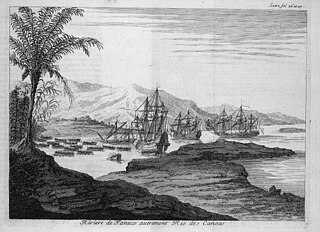
The Pánuco River, also known as the Río de Canoas, is a river in Mexico fed by several tributaries including the Moctezuma River and emptying into the Gulf of Mexico. The river is approximately 510 kilometres (320 mi) long and passes through or borders the states of Mexico, Hidalgo, Querétaro, San Luis Potosí, Tamaulipas, and Veracruz. Since one of the headwaters of the Moctezuma River is the Tula River, the Pánuco ultimately drains the Valley of Mexico containing Mexico City.
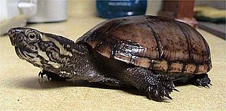
Kinosternon is a genus of small aquatic turtles from the Americas known commonly as mud turtles.
Federal Highway 2 is a free part of the federal highway corridors that runs along the Mexico–United States border. The highway is in two separate improved segments, starting in the west at Tijuana, Baja California, on the Pacific coast and ending in the east in Matamoros, Tamaulipas, on the Gulf of Mexico. Fed. 2 passes through the border states of Baja California, Sonora, Chihuahua, Coahuila, Nuevo Leon and Tamaulipas. It has a total length of 1,963 kilometres (1,220 mi); 1,319 kilometres (820 mi) in the west and 644 kilometres (400 mi) in the east.

Plutarco Elías Calles is a municipality in the northwest of the Mexican state of Sonora. Its municipal seat and main urban center is Sonoyta, on the United States border opposite Lukeville, Arizona.

The Sonora mud turtle, also known as the Sonoyta mud turtle, is a species of turtle in the Kinosternidae family. It is found in Mexico and the United States.

The Sierra Pinta or Sierra Pintas are a narrow remote block faulted northwest-southeast trending mountain range, about 22 miles (35 km) long located in southwestern Arizona in the arid northwestern Sonoran Desert, just north of the Pinacate Reserve of northern Sonora, Mexico. The mountains derive their name from visitor descriptions of its multicolored hues when viewed at sunrise and sunset.

El Camino del Diablo, also known as El Camino del Muerto, Sonora Trail, Sonoyta-Yuma Trail, Yuma-Caborca Trail, and Old Yuma Trail, is a historic 250-mile (400 km) road that passes through some of the most remote and inhospitable terrain of the Sonoran Desert in Pima County and Yuma County, Arizona. The name refers to the harsh, unforgiving conditions on the trail.

The Baluarte River, is a river of Mexico in the states of Durango and Sinaloa, traversing 142 km, part of which forms the border between these two states.

The SabinasRiver is a river of Mexico. It is a tributary of the Rio Salado, which in turn flows into the Rio Grande.
Río Verde,, is a river of San Luis Potosí state in eastern Mexico.
The Agua Dulce Mountains are a mountain range in the north-central Sonoran Desert of southwestern Arizona. The range is located in the extreme southwestern portion of Pima County, Arizona, immediately north of the international boundary with Mexico and about 30 miles southwest of Ajo, Arizona. The range has three main sections that total about 15 miles in length and about nine miles in width. The range is located entirely within the Cabeza Prieta National Wildlife Refuge. The highpoint of the range is 2,852 feet above sea level and is located at 32°01'32"N, 113°08'44"W. The summit is unnamed, but is marked on U.S. Geological Survey (USGS) maps for the "Quitovaquita" benchmark that was placed on the summit in 1920. The original surveyed height was 2,850 feet above sea level, but recent datum adjustments calculate the summit to be two feet higher.
Black Creek of Arizona is a 55-mi (89 km) long north tributary of the Puerco River, in northeast Arizona and northwest New Mexico.
