According to the actual naming, it has a length of 29.4 kilometres (18.3mi). It is formed by the confluence of two streams or small rivers. The shorter one is called Stente. It is the outlet of a lake called Bistensee. Half way it passes the mill's pond of the hamlet of Stenten. Below this pond it was called "Sorge", too, as late as in official maps printed in the year 2000. The main affluent of Bistensee and the length of this lake included, this top tributary is 11.15 kilometres (6.93mi) long. The other top tributary is longer, 15.9 kilometres (9.9mi). Its upper section is called Boklunder Au, the lower one Mühlenau, in 2000 still Mühlenbach. But there is another Mühlenbach (mill stream), nearby, joining river Sorge from the left (i.e. southern) side.
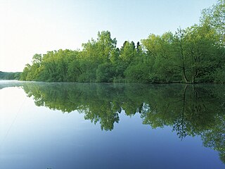
From the confluence of its sources, river Sorge mainly flows westward. In the moraine region of Geest, it is crossed by the historical Oxen Way, as Hærvejen is called in Germany. West of it and much more in the marshes west of Tetenhusen, the course of the river underwent great changes since the early 17th century, due to the cultivation efforts of Dutch settlers. Parts of the old course have disappeared, but a significant rest, up river cut off the waterway and called Alte Sorge, is a natural reserve, now.
The Patapédia River is a tributary of the Restigouche River in Northwest New Brunswick and Southeast Quebec, in Canada.
The Alster is a right tributary of the Elbe river in Northern Germany. It has its source near Henstedt-Ulzburg, Schleswig-Holstein, flows somewhat southwards through much of the Free and Hanseatic City of Hamburg and joins the Elbe in central Hamburg.
The Sulm is a river in the Heilbronn district of Baden-Württemberg, Germany. It is an unnavigable right tributary of the Neckar. It rises in the Löwenstein Mountains and after 26.3 kilometres (16.3 mi) distance and 315 metres (1,033 ft) elevation drop flows into the Neckar at Bad Friedrichshall, near Untereisesheim and Neckarsulm. Its valley together with its tributary valleys is also known as the Weinsberg Valley, after Weinsberg, which is located there. The medieval region of Sulmgau, as well as the city of Neckarsulm, were named for it. The upper valley of the Sulm is a protected area.
The Treene is a river, hydrologically 95 km (59 mi) and nominally 73.4 km (45.6 mi) long, in the north of Schleswig-Holstein, Germany. It is a right-bank tributary of the River Eider. It starts in northern Angeln, southeast of Flensburg, and flows mainly south-south-west before joining the Eider near Friedrichstadt.
The Clyde River is a tributary of Lake Memphremagog, over 33.5 miles (54 km) long, in northern Vermont in the United States. It is the easternmost of the four major rivers in Orleans County. It is the most powerful of the four within Orleans County, powering several turbines at damsites. It is part of the Northern Forest Canoe Trail.
The Schwentine is a river in the North German state of Schleswig-Holstein. It is approximately 62 kilometres (39 mi) long and rises on the hill of Bungsberg, the highest point in the state, near the village of Kasseedorf in Ostholstein. It then runs from its source to Kiel where it flows into the Kiel Fjord, a bay of the Baltic Sea. It passes through several lakes, including the Großer Plöner See, the largest lake in Schleswig-Holstein, as well as the towns Eutin, Malente, Plön, Preetz and Kiel.
The Baker Branch Saint John River is a 48.0-mile-long (77.2 km) river. This river is a tributary of the Saint John River, flowing in the Maine North Woods, in Maine, in the Northeastern United States.
The Southwest Branch Saint John River is a 62.0-mile-long (99.8 km) river in Maine and Quebec. The branch originates in "Little Saint John Lake" on the international boundary between Saint-Zacharie, Quebec and Seboomook Lake Township 5, Range 20, WELS. The branch forms the Canada–United States border as it flows northeasterly to a confluence with the Little Southwest Branch Saint John River in Seboomook Lake Township 9, Range 18, WELS. The Southwest Branch flows briefly into Quebec and then through Maine to its confluence with the Baker Branch Saint John River in Seboomook Lake Township 9, Range 17, WELS. The Southwest Branch finally joins with the Northwest Branch to form the Saint John River.
The Große Aue is an 88-kilometre-long (55 mi), southwestern, left tributary of the River Weser in northern North Rhine-Westphalia and central Lower Saxony in Germany.
The Bramau is an eastern tributary of the Stör in the German state of Schleswig-Holstein.
The Montmorency River is a tributary of North-East bank of St. Lawrence river, flowing in the administrative region of Capitale-Nationale, in the province of Quebec, Canada. The course of the river successively crosses the regional county municipality of:
The Lude is an 7.0-kilometre (4.3 mi) long stream of Saxony-Anhalt, in the Harz Mountains of central Germany. It is the strongest and – besides an affluent of itself – longest headwater of the Thyra and therefore hydrographically defined as its upper course.
The Hütten Hills are an area of upland, up to 105.8 m above sea level (NHN), roughly west of the town of Eckernförde in the county of Rendsburg-Eckernförde in the North German state of Schleswig-Holstein. They lie within the Hütten Hills Nature Park.
The Depot River is a tributary of the Big Black River, flowing in the townships T12 R17 Wels, T13 R16 Wels and T14 R15 Wels, in the Aroostook County in North Maine Woods in Maine, in United States.
The Eider Canal was an artificial waterway in southern Denmark which connected the North Sea with the Baltic Sea by way of the rivers Eider and Levensau. Constructed between 1777 and 1784, the Eider Canal was built to create a path for ships entering and exiting the Baltic that was shorter and less storm-prone than navigating around the Jutland peninsula. In the 1880s the canal was replaced by the enlarged Kiel Canal, which includes some of the Eider Canal's watercourse.
The Rivière aux Écorces is a tributary of the Pikauba River, in the province of Quebec, in Canada. Its course successively crosses the regional county municipalities (MRC) of:
The Rivière aux Canots is a tributary of the Rivière aux Écorces, in the province of Quebec, in Canada. Rivière aux Canots crosses the MRC of:
The Rivière Portneuf is a tributary of the north shore of the Saint-Laurent river, crossing the municipalities of Saint-Raymond, Pont-Rouge, Sant-Basile and Portneuf, in the Portneuf Regional County Municipality, in the administrative region of the Capitale-Nationale, in the province of Quebec, in Canada.
The Sutton River, North Branch Missisquoi River in the United States, is a transboundary watercourse tributary of the Missisquoi River, crossing from north to south:
The rivière au Pin is a tributary of the Bécancour River which is a tributary of the south shore of the St. Lawrence River, in Quebec, in Canada.
This page is based on this Wikipedia article Text is available under the CC BY-SA 4.0 license; additional terms may apply. Images, videos and audio are available under their respective licenses.