The Kiel Canal is a 98-kilometer-long (61 mi) fresh water canal that links the North Sea to the Baltic Sea. It runs through the German state of Schleswig-Holstein, from Brunsbüttel to the Holtenau district of Kiel. It was constructed from 1887 to 1895 and widened from 1907 to 1914. In addition to the two sea entrances, at Oldenbüttel the Kiel Canal is linked to the navigable River Eider by the short Gieselau Canal.

Schleswig-Holstein is the northernmost of the 16 states of Germany, comprising most of the historical Duchy of Holstein and the southern part of the former Duchy of Schleswig. Its capital city is Kiel; other notable cities are Lübeck and Flensburg. It covers an area of 15,763 km2 (6,086 sq mi), making it the 5th smallest German federal state by area. Historically, the name can also refer to a larger region, containing both present-day Schleswig-Holstein and the former South Jutland County in Denmark.

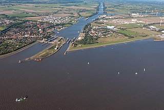
Rendsburg is a town on the River Eider and the Kiel Canal in the central part of Schleswig-Holstein, Germany. It is the capital of the Kreis (district) of Rendsburg-Eckernförde. As of 2006, it had a population of 28,476.
Holstein is the region between the rivers Elbe and Eider. It is the southern half of Schleswig-Holstein, the northernmost state of Germany.

The history of Schleswig-Holstein consists of the corpus of facts since the pre-history times until the modern establishing of the Schleswig-Holstein state.

Angeln is a peninsula on the Baltic coast of Jutland, in the Bay of Kiel. It forms part of Southern Schleswig, the northernmost region of Germany. The peninsula is bounded on the north by the Flensburg Firth, which separates it from Sundeved and the island of Als in Denmark, and on the south by the Schlei, which separates it from Schwansen. The landscape is hilly, dotted with numerous lakes. The largest towns are Flensburg, Schleswig and Kappeln.

Bovenau is a village in the district of Rendsburg-Eckernförde, in the German state of Schleswig-Holstein. Bovenau is only 16 metres (52 ft) above sea level. The location is south of the municipality of Bünsdorf or Sehestedt, but north of Ostenfeld, Bredenbek, and west of Krummwisch, about 20 km (12 mi) away from the center of Kiel.
Büdelsdorf is a town in the district of Rendsburg-Eckernförde, in Schleswig-Holstein, Germany. It is situated on the river Eider and the Kiel Canal, approx. 2 kilometres north of Rendsburg, and 30 km (19 mi) west of Kiel, just 5 mi (8 km) off the motorway.

The Treene is a river, hydrologically 95 km (59 mi) and nominally 73.4 km (45.6 mi) long, in Southern Schleswig in the north of Schleswig-Holstein, Germany. It is a right-bank tributary of the River Eider. It starts in northern Angeln, southeast of Flensburg, and flows mainly south-south-west before joining the Eider near Friedrichstadt.
Pahlen is a municipality in the district of Dithmarschen, Schleswig-Holstein, located in northern Germany. Situated along the Eider River within the Heide-Itzehoe Geest natural area, Pahlen offers a unique blend of historical significance, cultural landmarks, and natural beauty. The village, which has been an important settlement for centuries, continues to thrive as a vibrant community with a population of 1,153 as of December 31, 2022.

Koldenbüttel is a municipality in the district of Nordfriesland, in Schleswig-Holstein, Germany.

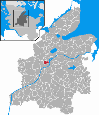
Schülp bei Rendsburg is a municipality in the district of Rendsburg-Eckernförde, in Schleswig-Holstein, Germany.

Westerrönfeld is a municipality in the district of Rendsburg-Eckernförde, in Schleswig-Holstein, Germany. The name literally means "The field west of the Rön", the Rön being a little tributary of the river Eider. Westerrönfeld is located on the southern bank of the Kiel Canal.

Jutland is a peninsula of Northern Europe that forms the continental portion of Denmark and part of northern Germany (Schleswig-Holstein). It stretches from the Grenen spit in the north to the confluence of the Elbe and the Sude in the southeast. The historic southern border river of Jutland as a cultural-geographical region, which historically also included Southern Schleswig, is the Eider. The peninsula, on the other hand, also comprises areas south of the Eider: Holstein, the former duchy of Lauenburg, and most of Hamburg and Lübeck.

The Eider-Treene Depression is a landscape in west Schleswig-Holstein in North Germany. It covers 500 square kilometres (190 sq mi) around the rivers Eider, Treene and Sorge. The Eider-Treene Depression is the largest wetland in the German state of Schleswig-Holstein. It includes one third of the moorland (bog) in the state and is a habitat to the largest inland group of meadow birds. To the north, its border runs between Hollingstedt and Treia, to the east near Rendsburg, to the south the boggy depression reaches to the Hanerau and Haalerau beyond the Kiel Canal. Its western boundary with the Eiderstedt Marsh is unclear as marsh, bog and geest are interspersed. The region comprises the river valleys and their interfluvial geest ridges (Geestkernen). The landscape was formed during the ice ages, and altered by man as a result of dams and weirs built across the Eider, which was still a tidal river as far as Rendsburg until the 1920s. The region recently is encouraging "nature tourism" with walking, riding, cycling and canoe trips.

The Eider Barrage is located at the mouth of the river Eider near Tönning on Germany's North Sea coast. Its main purpose is to protect against storm surges from the North Sea. It is Germany's largest coastal protection structure. It was also intended to contribute to economic recovery in the districts of Norderdithmarschen and Eiderstedt.

The Husum–Kiel railway is a main line railway in the German state of Schleswig-Holstein. While the central section of the line, which is shared with the Neumünster–Flensburg line, has two tracks and is electrified, its western and eastern sections are single track and are not electrified. It connects the cities of Husum and Kiel via Rendsburg and serves as an important east-west rail axis between the North Sea and the Baltic Sea.

The Flensburg–Husum–Tönning Railway Company built the first railway line in the Danish Duchy of Schleswig. The line opened in 1854 and was one of the first Danish railways.

The Eider Canal was an artificial waterway in southern Denmark which connected the North Sea with the Baltic Sea by way of the rivers Eider and Levensau. Constructed between 1777 and 1784, the Eider Canal was built to create a path for ships entering and exiting the Baltic that was shorter and less storm-prone than navigating around the Jutland peninsula. In the 1880s the canal was replaced by the enlarged Kiel Canal, which includes some of the Eider Canal's watercourse.

The Bundesstraße 202 is a German federal road or Bundesstraße and the west–east link between Sankt Peter Ording, Tönning, Friedrichstadt, Rendsburg, Kiel, Lütjenburg and Oldenburg in Holstein in the central part of the state of Schleswig-Holstein.


