Eider Canal

Last updated

Eider Canal
Map of the Kiel Canal and Eiderkanal.png
Map of the Eider Canal (blue) and succeeding Kiel Canal in Schleswig-Holstein
Specifications
Length107 miles (172 km)
(Man-made segment ran for 26 miles (42 km) [1] )
Locks6
Maximum height above sea level23 ft (7.0 m)
StatusReplaced by Kiel Canal
History
Date of act14 April 1774
Construction began1776
Date completed1784 (1784)
Date closed1887
Geography
Start point Tönning (North Sea)
End point Kiel (Baltic Sea)

The Eider Canal (also called the Schleswig-Holstein Canal) was an artificial waterway in southern Denmark (later northern Germany) which connected the North Sea with the Baltic Sea by way of the rivers Eider and Levensau. Constructed between 1777 and 1784, the Eider Canal was built to create a path for ships entering and exiting the Baltic that was shorter and less storm-prone than navigating around the Jutland peninsula. In the 1880s the canal was replaced by the enlarged Kiel Canal, which includes some of the Eider Canal's watercourse. [2]

Contents

Names

The canal's watercourse followed the border between the duchies of Schleswig and Holstein, and from the time of its construction it was known as the "Schleswig-Holstein Canal". After the First Schleswig War, the Danish government renamed the waterway the "Eider Canal" to resist the German nationalist idea of Schleswig-Holstein as a single political entity; but, when the region passed into Prussian control after the Second Schleswig War, the name was reverted to the "Schleswig-Holstein Canal." In modern historiography the canal is referred to by either name. [3]

History

As early as 1571 Duke Adolf I of Holstein-Gottorp proposed to build an artificial waterway across Schleswig-Holstein by connecting an eastward bend of the River Eider to the Baltic Sea, so as to compete with the nearby Stecknitz Canal for merchant traffic. [4] At the time the Duke of Holstein-Gottorp was a vassal of the Kingdom of Denmark, but the dukes of Schleswig-Holstein were perennial enemies to their Danish suzerains, and the political fragmentation of the region and the ongoing conflict over its rightful rule posed an insurmountable obstacle to such a large project. [5] The prospect of a canal was again raised in the 1600s under King Christian IV and Duke Frederick III. [6]

After the incorporation of Holstein into the Danish crown by the 1773 Treaty of Tsarskoye Selo, geopolitical conditions at last permitted a canal's construction and operation. Surveying and planning for the canal began in 1773, with a preliminary plan for the canal proposed in February 1774. On 14 April 1774, King Christian VII of Denmark issued a cabinet order establishing a Canal Commission to oversee the construction, led by Heinrich Carl von Schimmelmann. [6] [7]

Construction

The canal's most easterly lock at Kiel-Holtenau in 1894 Wd b048.JPG
The canal's most easterly lock at Kiel-Holtenau in 1894

Preparations for the canal began in 1776 with dredging of the lower Eider between Friedrichstadt and Rendsburg. The artificial canal was then excavated and fitted with locks to allow ships to cross the peninsula's drainage divide and descend to the Kieler Förde on the Baltic coast. Construction on the artificial segment, eventually 34 kilometres (21 mi) long, began in July 1777 at Holtenau on the Baltic shore north of Kiel, proceeding to Knoop by the following autumn. This section partly followed the small river Levensau that emptied into the Kieler Förde. The section from Knoop to Rathmannsdorf was built between 1778 and 1779, and the highest segment (connecting to the Flemhuder See) was completed in 1780. Finally, locks were installed along the upper Eider's natural course, starting at Rendsburg, to raise and deepen the river and make its upper reaches navigable as far as the western end of the artificial canal. [3]

Including 130 kilometres (81 mi) of the Eider and a 9-kilometre (5.6 mi) stretch passing through the Upper Eider Lakes at Rendsburg, the shipping route covered a total length of 173 kilometres (107 mi). Between the Baltic and the upper Eider there was a difference in elevation of about 7 metres (23 ft), which required the construction of six locks, located at Rendsburg, Kluvensiek, Königsförde, Rathmannsdorf, Knoop, and Holtenau (from west to east). All construction work was completed by the fall of 1784. [1] [8]

Replacement by Kiel Canal

The Eider Canal soon carried a considerable volume of shipping, and as decades passed the growing number and size of the ships wanting to make the crossing strained the canal's capacity. The winding course of the Eider and the need to navigate through the Frisian Islands at the canal's west end added to the travel time, and the drafts of late-nineteenth-century warships precluded their using the canal. In 1866 the Second Schleswig War resulted in Schleswig-Holstein's becoming part of Prussia, after which the German government explored a number of options for renovating or replacing the canal to improve commercial and military access to the Baltic. [9]

In 1887 Kaiser Wilhelm I inaugurated construction on a new canal through Schleswig-Holstein called the Kiel Canal. Though the new canal's western end is farther south (at the mouth of the Elbe), much of the Eider Canal's watercourse was reused for the new waterway. Many sections were deepened, and some were straightened, cutting off bends that still exist as lakes. The new canal was opened by Kaiser Wilhelm II in 1895. [10]

Packing houses

The Kiel-Holtenau packing house and commemorative obelisk Kiel-Holtenau-Packhaus.JPG
The Kiel-Holtenau packing house and commemorative obelisk

In 1783, as part of the canal's development, three warehouses (called "packing houses" in German) were built along the watercourse: one at the Kiel-Holtenau lock, one at the Rendsburg lock, and one in the harbor area of Tönning. These structures allowed for the storage and handling of bulk goods transiting the canal, such as wool, cereals, coffee and salt. All three packing houses are made of bricks over a timber frame, with three full floors and an attic. The packing houses in Holtenau and Tönning are comparable in size, with approximately 4,000 square metres (43,000 sq ft) of floor space each; the Rendsburg packing house is substantially smaller than the other two. [8]

Course of the Canal

The canal's eastern end was in the Kieler Förde at the mouth of the river Levensau. The canal ran westward in the small river's natural bed to the first lock, by the Holtenau packing house, and on to the second, by Gut Knoop. At both of these sites there were pre-existing bridges across the Levensau. Then, for a short distance the canal separated from the Levensau to run northwest from Achtstückenberg to the third lock at Rathmannsdorf, where the canal reached its maximum elevation of 7 metres (23 ft) above sea level. The section of the canal from Knoop to the Rathmannsdorf lock has been preserved, with remains of the locks still standing. West of Rathmannsdorf the canal rejoined the riverbed of the Levensau and followed it westward until connecting with the Flemhuder See, which provided the reservoir of water for the operation of the canal's most elevated segment. [11]

From the Flemhuder See the canal proceeded westward to the south of Gut Rosenkranz until it came to a fourth lock at Klein Königsförde. From there it followed a long stretch of the Eider, a small detour northward from Königsförde to Grünhorst, and then a bend southward on Sehestedt to the fifth lock at Kluvensiek. The section from Klein Königsförde via Kluvensiek to Hohenfelde is still preserved today, along with remains of the lock system. From here the canal followed the Eider's natural river bed, flowing past Schirnau, Lehmbek, and Borgstedt before finally coming to Rendsburg, where the sixth and final lock stood, along with a second packing house. From Rendsburg the waterway followed the natural river Eider down to its confluence with the North Sea at Tönning, where a third packing house was built. [11]

Specifications

The artificial canal had a length of 34 kilometres (21 mi), a water-level width of 28.7 metres (94 ft), a bottom width of 18 metres (59 ft) and a depth of 3.45 metres (11.3 ft), making a water-carrying cross-section of 83 square metres (890 sq ft). Ships of up to 28.7 metres (94 ft) length, 7.5 metres (25 ft) width, 2.7 metres (8.9 ft) draft and 140 tonnes (310,000 lb) displacement were allowed to pass through the channel. [9] [12] A passage through the canal and along the Eider took three days or more; in unfavorable wind ships were drawn by horses on the accompanying towpaths. In more than one hundred years of operation, the canal was crossed by about 300,000 ships. [4]

Preservation

The lock and bascule bridge at Kluvensiek in 2013 Kluvensieker Schleuse 2013a 01.jpg
The lock and bascule bridge at Kluvensiek in 2013

Significant parts of the former Eider Canal, along with four of its locks, are now in protected areas as important elements of the historical and cultural landscape in Schleswig-Holstein. The Holtenau lock, the Rathmannsdorf lock by Altenholz, the lock at Klein Königsförde in Krummwisch, and the Kluvensiek lock in Bovenau (along with its drawbridge) are now under cultural monument protection. Segments of the old canal in Bovenau and in Altenholz have been designated as landscape conservation areas. [4]

See also

Related Research Articles

<span class="mw-page-title-main">Kiel Canal</span> Canal in Germany

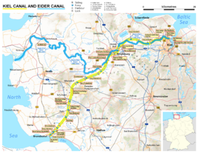
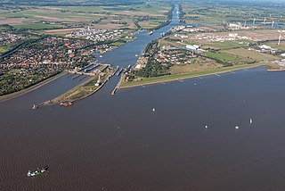
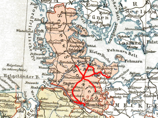
The Kiel Canal is a 98 km (61 mi) long freshwater canal in the German state of Schleswig-Holstein. The canal was finished in 1895, but later widened, and links the North Sea at Brunsbüttel to the Baltic Sea at Kiel-Holtenau. An average of 250 NM (460 km) is saved by using the Kiel Canal instead of going around the Jutland Peninsula. This not only saves time but also avoids storm-prone seas and having to pass through the Danish straits.

<span class="mw-page-title-main">Kiel</span> German city, capital of Schleswig-Holstein

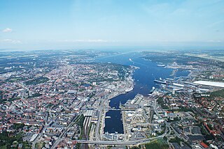
Kiel is the capital and most populous city in the northern German state of Schleswig-Holstein, with a population of 249,023 (2016).

<span class="mw-page-title-main">Rendsburg</span> Town in Schleswig-Holstein, Germany

Rendsburg is a town on the River Eider and the Kiel Canal in the central part of Schleswig-Holstein, Germany. It is the capital of the Kreis (district) of Rendsburg-Eckernförde. As of 2006, it had a population of 28,476.

<span class="mw-page-title-main">Elbe–Lübeck Canal</span> Waterway in northern Germany

The Elbe–Lübeck Canal is an artificial waterway in eastern Schleswig-Holstein, Germany. It connects the rivers Elbe and Trave, creating an inland water route across the drainage divide from the North Sea to the Baltic Sea. The canal includes seven locks and runs for a length of 64 kilometres (40 mi) between the cities of Lübeck in the north and Lauenburg in the south by way of the Mölln lakes. The modern canal was built in the 1890s to replace the Stecknitz Canal, a medieval watercourse linking the same two rivers.

<span class="mw-page-title-main">Holstein</span> Historical region in the Southern half of Schleswig-Holstein

Holstein is the region between the rivers Elbe and Eider. It is the southern half of Schleswig-Holstein, the northernmost state of Germany.

<span class="mw-page-title-main">Eider (river)</span> River in Schleswig-Holstein, Germany

The Eider is the longest river in the German state of Schleswig-Holstein. The river starts near Bordesholm and reaches the southwestern outskirts of Kiel on the shores of the Baltic Sea, but flows to the west, ending in the North Sea. The lower part of the Eider was used as part of the Eider Canal until that canal was replaced by the modern Kiel Canal.

<span class="mw-page-title-main">Bay of Kiel</span>

The Bay of Kiel or Kiel Bay is a bay in the southwestern Baltic Sea, off the shores of Schleswig-Holstein in Germany and the islands of Denmark. It is connected with the Bay of Mecklenburg in the east, the Little Belt in the northwest, and the Great Belt in the North.

<span class="mw-page-title-main">Achterwehr</span> Municipality in Schleswig-Holstein, Germany

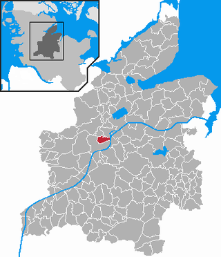
Achterwehr is a municipality, located in the district of Rendsburg-Eckernförde in the German Bundesland of Schleswig-Holstein.

<span class="mw-page-title-main">Bovenau</span> Municipality in Schleswig-Holstein, Germany

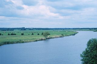
Bovenau is a village in the district of Rendsburg-Eckernförde, in the German state of Schleswig-Holstein. Bovenau is only 16 metres (52 ft) above sea level. The location is south of the municipality of Bünsdorf or Sehestedt, but north of Ostenfeld, Bredenbek, and west of Krummwisch, about 20 km (12 mi) away from the center of Kiel.

<span class="mw-page-title-main">Büdelsdorf</span> Town in Schleswig-Holstein, Germany

Büdelsdorf is a town in the district of Rendsburg-Eckernförde, in Schleswig-Holstein, Germany. It is situated on the river Eider and the Kiel Canal, approx. 2 kilometres north of Rendsburg, and 30 km (19 mi) west of Kiel, just 5 mi (8 km) off the motorway.

<span class="mw-page-title-main">Danish Wahld</span>

The Danish Wahld is a peninsula in Schleswig-Holstein, Germany. It is located between Eckernförde Bay in the north and Kiel Fjord in the south. The Amt of "Dänischer Wohld" in the district of Rendsburg-Eckernförde is named after the peninsula, but only encompasses a central part of the region.

<span class="mw-page-title-main">Stecknitz Canal</span> Former waterway in northern Germany

The Stecknitz Canal was an artificial waterway in northern Germany which connected Lauenburg and Lübeck on the Old Salt Route by linking the tiny rivers Stecknitz and Delvenau, thus establishing an inland water route across the drainage divide from the North Sea to the Baltic Sea. Built between 1391 and 1398, the Stecknitz Canal was the first European summit-level canal and one of the earliest artificial waterways in Europe. In the 1890s the canal was replaced by an enlarged and straightened waterway called the Elbe–Lübeck Canal, which includes some of the Stecknitz Canal's watercourse.

<span class="mw-page-title-main">Treene (river)</span> River in Schleswig-Holstein, Germany

The Treene is a river, hydrologically 95 km (59 mi) and nominally 73.4 km (45.6 mi) long, in the north of Schleswig-Holstein, Germany. It is a right-bank tributary of the River Eider. It starts in northern Angeln, southeast of Flensburg, and flows mainly south-south-west before joining the Eider near Friedrichstadt.

<span class="mw-page-title-main">Duchy of Holstein</span> Territory of the Holy Roman Empire

The Duchy of Holstein was the northernmost state of the Holy Roman Empire, located in the present German state of Schleswig-Holstein. It originated when King Christian I of Denmark had his County of Holstein-Rendsburg elevated to a duchy by Emperor Frederick III in 1474. Members of the Danish House of Oldenburg ruled Holstein – jointly with the Duchy of Schleswig – for its entire existence.

<span class="mw-page-title-main">Kieler Förde</span>

Kieler Förde is an approximately 17 km (11 mi) long inlet of the Baltic Sea on the eastern side of Schleswig-Holstein, Germany. Formed by glacial movement during the last ice age, it divides Danish Wold peninsula from Wagria. Like the other inlets of förde-type, geologically it is not a fjord. It originates at the Hörn in centre-city Kiel and merges into the Bay of Kiel.

<span class="mw-page-title-main">Schülp bei Rendsburg</span> Municipality in Schleswig-Holstein, Germany

Schülp bei Rendsburg is a municipality in the district of Rendsburg-Eckernförde, in Schleswig-Holstein, Germany.

<span class="mw-page-title-main">Westerrönfeld</span> Municipality in Schleswig-Holstein, Germany

Westerrönfeld is a municipality in the district of Rendsburg-Eckernförde, in Schleswig-Holstein, Germany. The name literally means "The field west of the Rön", the Rön being a little tributary of the river Eider. Westerrönfeld is located on the southern bank of the Kiel Canal.

<span class="mw-page-title-main">Neumünster–Flensburg railway</span>

The Neumünster Flensburg Railway is part of the Jutland line, the main north–south rail link through Schleswig-Holstein, Germany. Together with the line to Husum, which diverges in Jübek, and the line to Kiel, which diverges in Rendsburg, it also serves as an important east–west axis between Kiel and the Marsh Railway on the west coast. It consists of several sections that were parts of the first railways in the current territory of Germany.

<span class="mw-page-title-main">Altona-Kiel Railway Company</span> Railway company

The Altona-Kiel Railway Company was a joint-stock company, established under the law of Denmark in personal union with the Duchy of Holstein, that built and operated an 105 km railway line between Altona and the Baltic Sea port city of Kiel. Altona was at that time the second largest city under Danish rule and the railway line was the first built in Danish-controlled territory.

<span class="mw-page-title-main">Holtenau</span> Urban district in Schleswig-Holstein, Germany

Holtenau is a district of Kiel, on the southeastern part of the Danish Wahld. It was historically part of the Duchy of Schleswig, and has cultural influences from both Germany and Denmark.

References

  1. 1 2 Vernon-Harcourt, Leveson Francis (1896). Rivers and Canals (2nd ed.). Oxford: Clarendon Press. p.  571.
  2. "Eider River". Encyclopædia Britannica . Retrieved 19 October 2016.
  3. 1 2 "Der Alte Eiderkanal (Schleswig-Holsteinischer Canal)". Geschichte Kiel-Holtenaus (in German). Retrieved 24 October 2016.
  4. 1 2 3 Watty, Fred (2012). Kiel and the fjord region. Sutton Verlag GmbH. pp. 45–46. ISBN   9783954000616 . Retrieved 29 October 2016.
  5. Ward, Sir Adolphus William; Prothero, George Walter; Leathes, Sir Stanley Mordaunt; Benians, Ernest Alfred (1908). The Cambridge Modern History. Vol. 5. Macmillan. p. 580. Retrieved 29 October 2016.
  6. 1 2 "Geschichte des Eiderkanals". Canal-Verein e.V. (in German). Archived from the original on 16 July 2018.
  7. Jessen-Klingenberg, Manfred (March 2010). "Der Schleswig-Holsteinische Kanal − Eiderkanal. Vorgeschichte, Entstehung, Bedeutung". Mitteilungen der Kieler Gesellschaft für Stadtgeschichte (in German) (85): 116.
  8. 1 2 Witte, Christiane (2008). Das Tönninger Packhaus – 225 Jahre alt (in German).
  9. 1 2 Hansen, Christian (1860). The Great Holstein Ship-canal from Brunsbüttel to the Bay of Neustadt, for Uniting the Northsea and the Baltic. p. 6. Retrieved 29 October 2016.
  10. "The history of the Kiel Canal". City of Kiel. Retrieved 27 October 2016.
  11. 1 2 Quedenbaum, Gerd (1984). Im Spiegel der Lexika: Eider, Kanal und Eider-Canal (in German). Düsseldorf: Verlag Butendörp. ISBN   9783921908051.
  12. Jensen, Waldemar (1970). "Vorgeschichte des Kanalbaus". Der Nord-Ostsee-Kanal: Eine Dokumentation zur 75jährigen Wiederkehr der Eröffnung (in German). Neumünster: Verlag Wachholtz. p. 40.

Coordinates: 54°20′37″N9°49′47″E / 54.3435°N 9.8298°E / 54.3435; 9.8298