Ludwig Canal

Last updated
Map of the Ludwigskanal Ludwigskanal-Karte.jpg
Map of the Ludwigskanal
The various projects to link the Main and Danube Verbindung main donau.png
The various projects to link the Main and Danube
Karte und Langenprofil des Ludwig Kanales, Stahlstich (1845) von Alexander Marx Karte und Hohenprofil Ludwig Kanal.jpg
Karte und Längenprofil des Ludwig Kanales, Stahlstich (1845) von Alexander Marx

The Ludwig Canal (German: Ludwig-Donau-Main-Kanal or Ludwigskanal), is an abandoned canal in southern Germany. [1]

Contents

Lock 100 at Bamberg Schleuse 100, 2004-03-28 JOF.JPG
Lock 100 at Bamberg

The canal linked the Danube River at Kelheim with the Main River at Bamberg, connecting the Danube basin with the Rhine basin. The first realisation of a dream to enable barges to navigate from the North Sea to the Black sea, the Ludwig Canal proved to be unsustainable, and was eventually succeeded by a larger canal, over a century later. [2] [3]

Named after King Ludwig I of Bavaria, the canal was built between 1836 and 1846. Whereas the Main and the Danube were both broad canalised rivers, the Ludwig Canal was a narrow channel, with numerous locks, and a shortage of water supply to the summit level. The canal became a bottleneck, and the operation of the waterway soon became uneconomic. A further nail in the canal's coffin was competition from the rapidly developing railway network in the southern German countryside. [4] Rather than repair the damage suffered during World War II, (the canal being close to the bombed city of Nuremberg), the canal was finally abandoned in 1950.

Construction of the Ludwig Canal's replacement, the much larger Rhine–Main–Danube Canal, was started in 1921, but not completed until 1992. The new canal is shorter and follows a route to the south and west of the earlier canal. [5]

The remnants of the Ludwig Canal

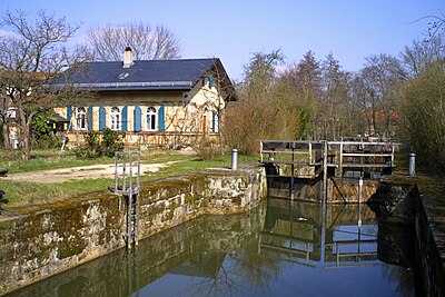
Today, there still exists between Nuremberg and Berching some 60 km of canal in good condition. Some of the locks still function, and part of the towpath has been converted to a cycle track. [6] The old canal comes close to the new canal at Pollanten, and from there the two canals flow downstream in parallel, eventually meeting 5 km south of Berching.

Related Research Articles

Main (river) River in Germany

The Main is the longest tributary of the Rhine. It rises as the White Main in the Fichtel Mountains of northeastern Bavaria and flows west through central Germany for 525 kilometres (326 mi) to meet the Rhine below Russelsheim, Hesse. The cities of Mainz and Wiesbaden are close to the confluence.

Rhine River in Western Europe

The Rhine is one of the major European rivers, and has its sources in Switzerland and flows in a mostly northerly direction through Germany and the Netherlands, emptying into the North Sea. The river begins in the Swiss canton of Graubünden in the southeastern Swiss Alps, forms part of the Swiss-Liechtenstein, Swiss-Austrian, Swiss-German and then the Franco-German border, then flows through the German Rhineland and the Netherlands and eventually empties into the North Sea.

Altmühl River in Bavaria, Germany

The Altmühl is a river in Bavaria, Germany. It is a left tributary of the river Danube and is approximately 230 kilometres (140 mi) long.

Rhine–Main–Danube Canal Canal in Bavaria, Germany

The Rhine–Main–Danube Canal, in Bavaria, Germany, connects the Main and the Danube rivers across the European Watershed, running from Bamberg via Nuremberg to Kelheim. The canal connects the North Sea and Atlantic Ocean to the Black Sea, providing a navigable artery between the Rhine delta, and the Danube Delta in south-eastern Romania and south-western Ukraine. The present canal was completed in 1992 and is 171 kilometres (106 mi) long.

Donauwörth Place in Bavaria, Germany

DonauwörthGerman: [ˌdoːnaʊˈvøːɐ̯t]) is a town and the capital of the Donau-Ries district in Swabia, Bavaria, Germany. It is said to have been founded by two fishermen where the rivers Danube (Donau) and Wörnitz meet. The city is part of the scenic route called "Romantische Straße".

Donaueschingen Town in Schwarzwald-Baar, Baden-Württemberg, Germany

Donaueschingen is a German town in the Black Forest in the southwest of the federal state of Baden-Württemberg in the Schwarzwald-Baar Kreis. It stands near the confluence of the two sources of the river Danube.

The Limes Germanicus is the name given in modern times to a line of frontier fortifications that bounded the ancient Roman provinces of Germania Inferior, Germania Superior and Raetia, dividing the Roman Empire and the unsubdued Germanic tribes from the years 83 to about 260 AD. The Limes used either a natural boundary such as a river or typically an earth bank and ditch with a wooden palisade and watchtowers at intervals. A system of linked forts was built behind the Limes.

Danube–Oder Canal

The Danube–Oder Canal is a planned and partially constructed artificial waterway in the Lobau floodplain of the Danube at Vienna, that was supposed to stretch along the Morava River to the Oder at the city of Kędzierzyn-Koźle in Poland.

Danube–Tisa–Danube Canal

Danube–Tisa–Danube Canal (DTD) is a canal system in Serbia. It is a unique hydro-engineering system for flood control and hydrotechnical management, amelioration, forestry, water supply, waste water evacuation, navigation, tourism, fishing, hunting.

Rhine–Herne Canal

The Rhine–Herne Canal is a 45.6-kilometre-long (28.3 mi) transportation canal in the Ruhr area of North Rhine-Westphalia, Germany, with five canal locks. The canal was built over a period of eight years and connects the harbour in Duisburg on the Rhine with the Dortmund-Ems Canal near Henrichenburg, following the valley of the Emscher. It was widened in the 1980s. The Rhein-Herne canal ship was designed specifically for this canal; normally of about 1300–1350 ton capacity, it has a maximum draft of 2.50 metres (8.2 ft), a length of approximately 80 metres (260 ft), and maximum beam of 9.50 metres (31.2 ft).

Berching Place in Bavaria, Germany

Berching is a town in the district of Neumarkt in Bavaria, Germany.

Riedenburg Place in Bavaria, Germany


Riedenburg is a town in the district of Kelheim, in Bavaria, Germany. It is situated on the river Altmühl, 16 km (10 mi) northwest of Kelheim and 29 km (18 mi) northeast of Ingolstadt. Prunn Castle (de) is located in Riedenburg.

Bavarian Ludwig Railway First steam-hauled railway in Germany (commenced service 1835)

The Bavarian Ludwig Railway was the first steam-hauled railway opened in Germany. The Königlich privilegierte Ludwigs-Eisenbahn-Gesellschaft received a concession to build a railway from Nuremberg to Fürth in the state of Bavaria on 19 February 1834.

Summit-level canal

A summit-level canal is an artificial waterway connecting two separate river valleys. The term refers to a canal that rises then falls, as opposed to a lateral canal, which has a continuous fall only. Summit-level canals were an essential step in developing transport systems connecting different parts of a country before the railways or modern road transport.

Danube River in Central and Eastern Europe

The Danube is Europe's second-longest river after the Volga, flowing through much of Central and Southeastern Europe, from the Black Forest into the Black Sea. Its longest headstream Breg rises in Furtwangen im Schwarzwald, while the river carries its name from its source confluence in Donaueschingen onwards.

Harbours in Vienna

For a long time, it was not necessary to build a Harbour in Vienna, because the existing natural landing points were sufficient for the level of trade on the Danube. It was only when steamships began to arrive in great numbers that a harbour offering safe berths became essential. Even then however, goods were for the most part loaded and unloaded at an unenclosed river harbour that was established at the end of the 19th century.

Fossa Carolina

The Fossa Carolina was a canal named after Charlemagne in what is today the German state of Bavaria, intended to connect the Swabian Rezat river to the Altmühl river. It was created during the early Middle Ages, long before the Ludwig Canal and the Rhine-Main-Danube Canal. If it was indeed operational, this canal would have been the first to link the Rhine basin to the Danube basin, across the European Watershed. However, contemporary sources are contradictory as to whether it was ever finished or not.

The Neumarkt–Dietfurt railway was a branch line between Neumarkt in der Oberpfalz and Dietfurt an der Altmühl in the German state of Bavaria. It ran south of Neumarkt along the Sulz and largely parallel to the Ludwig Canal to Beilngries and from there along the Altmühl to Dietfurt.

Eider Canal Former waterway in northern Germany

The Eider Canal was an artificial waterway in southern Denmark which connected the North Sea with the Baltic Sea by way of the rivers Eider and Levensau. Constructed between 1777 and 1784, the Eider Canal was built to create a path for ships entering and exiting the Baltic that was shorter and less storm-prone than navigating around the Jutland peninsula. In the 1880s the canal was replaced by the enlarged Kiel Canal, which includes some of the Eider Canal's watercourse.

References