Dietfurt is a town in the district of Neumarkt in Bavaria, Germany. The town is situated on the river Altmühl, and is 38 km west of Regensburg, 30 km north of Ingolstadt, and is located 364 meters above sea level.

Roth is a town in Bavaria, Germany, the capital of the Roth District. It is located about 25 km south of Nuremberg.

Neumarkt in der Oberpfalz is the capital of the Neumarkt district in the administrative region of the Upper Palatinate, in Bavaria, Germany. With a population of about 40,000, Neumarkt is the seat of various projects, and acts as the economic and cultural center of the western Upper Palatinate, along with Nürnberg, Ingolstadt, and Regensburg.

Hilpoltstein is a town in the district of Roth, in Bavaria, Germany. It is situated 10 km southeast of Roth bei Nürnberg and 30 km south of Nuremberg, close to the lake 'Rothsee.

Freystadt is a town in the district of Neumarkt in Bavaria. It is situated near the Rhine-Main-Danube Canal, 14 km southwest of Neumarkt in der Oberpfalz, and 33 km southeast of Nuremberg.

Neumarkt-Sankt Veit is a town in the district of Mühldorf, in Bavaria, Germany. It is located on the river Rott, 10 kilometers north of Mühldorf, and 33 kilometers southeast of Landshut.

Ornbau is a walled town in the district of Ansbach, in Bavaria, Germany. It is situated on the river Altmühl, 15 km southeast of Ansbach.

Parsberg is a town in the county of Neumarkt in Bavaria, Germany. It is 23 km southeast of Neumarkt in der Oberpfalz, and 33 km northwest of Regensburg, next to the A3 autobahn, the main route from Nuremberg to Regensburg. It was formerly the seat of the Counts of Parsberg, whose coat of arms is now used by the town.
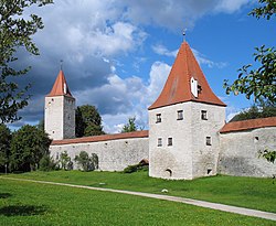
Zeil am Main is a town in the Haßberge district in Lower Franconia, an area in the federal state of Bavaria, Germany. It is situated on the right bank of the Main, 7 km east of Haßfurt, 24 km northwest of Bamberg, and 25 km east of Schweinfurt. Zeil is a historic Franconian town known for its old churches, romantic houses, medieval walls and towers, the hill church of "Zeiler Käpelle", and the castle ruins of the Schmachtenburg.

Postbauer-Heng is a municipality in the district of Neumarkt in Bavaria in Germany.

Berg bei Neumarkt in der Oberpfalz is a municipality in the district of Neumarkt in Bavaria in Germany.
Berngau is a municipality in the district of Neumarkt in Bavaria in Germany.

Breitenbrunn is a municipality in the district of Neumarkt in Bavaria in Germany.

Deining is a municipality in the district of Neumarkt in Bavaria in Germany.

Lupburg is a municipality in the district of Neumarkt in Bavaria in Germany.

Mühlhausen is a municipality in the district of Neumarkt in Bavaria in Germany. It lies in the Sulz River valley.

Pilsach is a municipality in the district of Neumarkt in Bavaria in Germany.
Pyrbaum is a municipality in the district of Neumarkt in Bavaria in Germany.

Sengenthal is a municipality in the district of Neumarkt in Bavaria in Germany.

Seubersdorf is a municipality in the district of Neumarkt in Bavaria in Germany.