Bavaria, officially the Free State of Bavaria, is a landlocked state of Germany, occupying its southeastern corner. With an area of 70,550.19 square kilometres (27,239.58 sq mi) Bavaria is the largest German state by land area comprising roughly a fifth of the total land area of Germany. With 13 million inhabitants, it is Germany's second-most-populous state after North Rhine-Westphalia. Bavaria's main cities are Munich, Nuremberg, and Augsburg.

Munich is the capital and most populous city of Bavaria, the second most populous German state. With a population of around 1.5 million, it is the third-largest city in Germany, after Berlin and Hamburg, and thus the largest which does not constitute its own state, as well as the 11th-largest city in the European Union. The city's metropolitan region is home to 6 million people.

Nuremberg is the second-largest city of the German federal state of Bavaria after its capital Munich, and its 511,628 (2016) inhabitants make it the 14th largest city in Germany. On the Pegnitz River and the Rhine–Main–Danube Canal, it lies in the Bavarian administrative region of Middle Franconia, and is the largest city and the unofficial capital of Franconia. Nuremberg forms a continuous conurbation with the neighbouring cities of Fürth, Erlangen and Schwabach with a total population of 798,867 (2018), while the larger Nuremberg Metropolitan Region has approximately 3.6 million inhabitants. The city lies about 170 kilometres (110 mi) north of Munich. It is the largest city in the East Franconian dialect area, Nuremberg was one of the host cities of the 2006 FIFA World Cup.

The County Palatine of the Rhine, later the Electorate of the Palatinate or simply Electoral Palatinate, was a territory in the Holy Roman Empire administered by the Count Palatine of the Rhine. Its rulers served as prince-electors (Kurfürsten) from time immemorial, were noted as such in a papal letter of 1261, and were confirmed as electors by the Golden Bull of 1356.

The House of Wittelsbach is a German-Bavarian dynasty, with branches that rule, or have ruled over territories including: Bavaria, Holland, Zeeland, Cologne, Sweden, Romania, Bohemia, Hungary, Denmark, Norway, Greece and the Holy Roman Empire. The House of Windsor, the reigning royal house of the British throne, are descendants of Sophia of Hanover, a Wittelsbach Princess and Electress of Hanover.

Baden-Württemberg is a state in southwest Germany, east of the Rhine, which forms the southern sector of Germany's western border with France. It is Germany's both third-largest, with an area of 35,751 km2 (13,804 sq mi) and third-most populous state with more than 11 million inhabitants. Baden-Württemberg is a parliamentary republic and partly sovereign, federated state which was formed in 1952 by a merger of the states of Württemberg-Baden, South Baden and Württemberg-Hohenzollern. The largest city in Baden-Württemberg is the state capital of Stuttgart, followed by Karlsruhe and Mannheim. Other cities are Freiburg im Breisgau, Heidelberg, Heilbronn, Pforzheim, Reutlingen, Tübingen and Ulm.
Lower Franconia is one of seven districts of Bavaria, Germany. The districts of Lower, Middle and Upper Franconia make up the region of Franconia.

The Upper Palatinate is one of the seven administrative districts of Bavaria, Germany, located in the east of Bavaria.

Ingolstadt is a city in Bavaria, Germany, on the banks of the Danube, in the centre of Bavaria. In 2016, it had 133,638 citizens, making it the fifth largest city in Bavaria. It is part of the Munich Metropolitan Region.

Maximilian II reigned as King of Bavaria between 1848 and 1864.
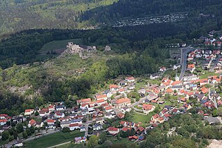
Flossenbürg is a municipality in the district of Neustadt an der Waldnaab in Bavaria in Germany. The state-approved leisure area is located in the Bavarian Forest and borders Bohemia in the east. During World War II, the Flossenbürg concentration camp was located here.
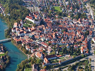
Füssen is a town in Bavaria, Germany, in the district of Ostallgäu, situated one kilometre from the Austrian border. The town is known for violin manufacturing and as the closest transportation hub for the Neuschwanstein and Hohenschwangau castles. As of 2018 the town has a population of 15,508.

The House of Hohenlohe is a German princely dynasty. It ruled an immediate territory within the Holy Roman Empire which was divided between several branches. The Hohenlohes became imperial counts in 1450. The county was divided numerous times and split into several principalities in the 18th century.

Neuburg an der Donau, literally Newcastle on the river Danube, is a town which is the capital of the Neuburg-Schrobenhausen district in the state of Bavaria in Germany.
Grünwald is a municipality in the district of Munich, in the state of Bavaria, Germany. It is located on the right bank of the Isar, 12 km southwest of Munich (centre). As of 31 December 2011 it had a population of 11,109.

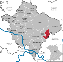
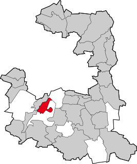
Parsberg is a town in the county of Neumarkt in Bavaria, Germany. It is situated 23 km southeast of Neumarkt in der Oberpfalz, and 33 km northwest of Regensburg, next to the A3 autobahn, the main route from Nuremberg to Regensburg. It was formerly the seat of the Counts of Parsberg, whose coat of arms is now used by the town.

Tittmoning is a town in the district of Traunstein, in Bavaria, Germany.
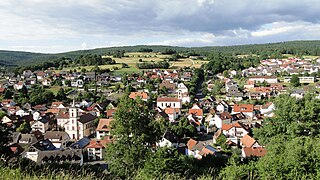
Partenstein is a community in the Main-Spessart district in the Regierungsbezirk of Lower Franconia (Unterfranken) in Bavaria, Germany and the seat of the Verwaltungsgemeinschaft of Partenstein. Partenstein is located on Bundesstraße 276.
Pullach, officially Pullach i. Isartal, is a municipality in the district of Munich in Bavaria in Germany. It lies on the Isar Valley Railway and is served by the S 7 line of the Munich S-Bahn, at the Großhesselohe Isartalbahnhof, Pullach and Höllriegelskreuth railway stations.

The Nuremberg–Regensburg railway is a 100-kilometre (62 mi) long mainline railway in the German state of Bavaria that runs from Nuremberg via Neumarkt in der Oberpfalz and Parsberg to Regensburg. It is one of the main routes to Austria for passengers and a link for regional transport between the Nuremberg region and the major centre of Regensburg. It is also one of the major routes for freight traffic to Eastern Europe. The line was opened by the Bavarian Eastern Railway Company between 1871 and 1873.