
Lusatia is a historical region in Central Europe, territorially split between Germany and modern-day Poland. Lusatia stretches from the Bóbr and Kwisa rivers in the east to the Pulsnitz and Black Elster rivers in the west, and is located within the German states of Saxony and Brandenburg as well as in the Polish voivodeships of Lower Silesia and Lubusz. Major rivers of Lusatia are the Spree and the Lusatian Neisse, which defines the border between Germany and Poland. The Lusatian Mountains of the Western Sudetes separate Lusatia from Bohemia in the south. Lusatia is traditionally divided into Upper Lusatia, the hilly southern part, and Lower Lusatia, the flat northern part.
Elbe-Elster is a Kreis (district) in the southern part of Brandenburg, Germany. Neighboring districts are Teltow-Fläming, Dahme-Spreewald, Oberspreewald-Lausitz, Meißen, Nordsachsen and Wittenberg. The district has a partnership with the Märkischer Kreis.
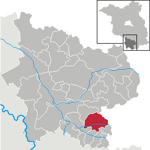
Oberspreewald-Lausitz is a Kreis (district) in the southern part of Brandenburg, Germany. Neighboring districts are Dahme-Spreewald, Spree-Neiße, the districts Bautzen and Meissen in Saxony, and the district Elbe-Elster.
Wittenberg is a district in the east of Saxony-Anhalt, Germany. Neighboring districts are Anhalt-Bitterfeld, the district-free city of Dessau-Roßlau, the districts of Potsdam-Mittelmark, Teltow-Fläming and Elbe-Elster in Brandenburg, and the district of Nordsachsen in Saxony. The capital and largest city is Wittenberg, famous for its association with the influential religious reformer Martin Luther and containing a UNESCO World Heritage Site.

The White Elster is a 257-kilometre (160 mi) long river in central Europe. It is a right tributary of the Saale. The source of the White Elster is in the westernmost part of the Czech Republic, in the territory of Hazlov. After a few kilometres, it flows into eastern Germany where it cuts through the Vogtland in a "deep and picturesque valley". In Germany it flows through the states of Saxony, Thuringia and Saxony-Anhalt. The White Elster flows through the cities of Plauen, Greiz, Gera, Zeitz, Pegau and Leipzig, and into the river Saale in Halle.

Lower Lusatia is a historical region in Central Europe, stretching from the southeast of the German state of Brandenburg to the southwest of Lubusz Voivodeship in Poland. Like adjacent Upper Lusatia in the south, Lower Lusatia is a settlement area of the West Slavic Sorbs whose endangered Lower Sorbian language is related to Upper Sorbian and Polish.

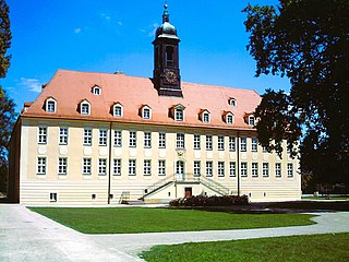
Senftenberg (German) or Zły Komorow is a town in Lower Lusatia, Brandenburg, in eastern Germany, capital of the Oberspreewald-Lausitz district.

The Lusatian Lake District is a chain of artificial lakes under construction in Germany across the north-eastern part of Saxony and the southern part of Brandenburg. Through flooding as a part of an extensive regeneration programme, several decommissioned lignite opencast mines are in the process of being transformed into Europe's largest artificial lake district. However, the requirements of the project, especially the necessary water resources, are controversial.
Elsterwerda is a town in the Elbe-Elster district, in southwestern Brandenburg, Germany. It is situated on the Black Elster river, 48 km northwest of Dresden, and 11 km southeast of Bad Liebenwerda.

is a town in the Oberspreewald-Lausitz district, in Upper Lusatia, Brandenburg, in eastern Germany. It is situated on the river Schwarze Elster, 12 kilometres (7.5 mi) southwest of Senftenberg.
Schwarzheide or Carny Gózd is a town in the Oberspreewald-Lausitz district, in Lower Lusatia, Brandenburg, Germany. It is situated on the river Schwarze Elster, 11 km southwest of Senftenberg, 110 km south of Berlin and 40 km north of Dresden. The little river Pössnitz runs through the eastern part of Schwarzheide.
Plessa is a municipality in the Elbe-Elster district, in Brandenburg, Germany.

Bezirk Cottbus was a district of the German Democratic Republic. The administrative seat and main town was Cottbus.

The term West Lusatia was coined in the 1950s for the old counties of Hoyerswerda, Kamenz and Bischofswerda – mainly in order to make the Museum of West Lusatia into a centrepoint. Culturally and historically, West Lusatia corresponds to western Upper Lusatia, including part of the Brandenburg county of Oberspreewald-Lausitz, between the rivers Pulsnitz and Black Elster.

Hosena station is a station at the junction of the Węgliniec–Roßlau railway and the Lübbenau–Kamenz railway. The station is located in the southeast of the German state of Brandenburg in the village of Hosena, north of the village of Hohenbocka.

Bertzit Tower is an investment ruin in the north of Kahla, which belongs to Plessa in the southern part of Brandenburg, itself part of the Elbe-Elster region.

Elbe-Elster Land, also called the Elbe-Elster region (Elbe-Elster-Gebiet) is a region around the tripoint of the German states of Brandenburg, Saxony-Anhalt and Saxony. It is part of the North German Plain and is named after the two major rivers that have their confluence here: the Elbe and the Black Elster.

The Elsterwerda–Grödel raft canal, established in the 18th century, serves as a waterway connecting the Pulsnitz River in Elsterwerda with the Elbe River near Grödel in Germany.

Prieschka is a district of the spa town of Bad Liebenwerda in Elbe-Elster in southern Brandenburg.

Zeischa is an Ortsteil of the spa town of Bad Liebenwerda in the district of Elbe-Elster in southern Brandenburg. The village is located about three kilometres from the town centre in the Lower Lusatian Heath Nature Park on the banks of the Black Elster River.

