The Meuse or Maas is a major European river, rising in France and flowing through Belgium and the Netherlands before draining into the North Sea from the Rhine–Meuse–Scheldt delta. It has a total length of 925 km.

Westphalia is a region of northwestern Germany and one of the three historic parts of the state of North Rhine-Westphalia. It has an area of 20,210 square kilometres (7,800 sq mi) and 7.9 million inhabitants.

North Rhine-Westphalia or North-Rhine/Westphalia, commonly shortened to NRW, is a state (Land) in Western Germany. With more than 18 million inhabitants, it is the most populous state in Germany. Apart from the city-states, it is also the most densely populated state in Germany. Covering an area of 34,084 km2 (13,160 sq mi), it is the fourth-largest German state by size.

Ahr is a river in Germany, a left tributary of the Rhine. Its source is at an elevation of approximately 470 metres (1,540 ft) above sea level in Blankenheim in the Eifel, in the cellar of a timber-frame house near the castle of Blankenheim. After 18 kilometres (11 mi) it crosses from North Rhine-Westphalia into Rhineland-Palatinate.

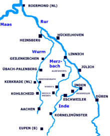
The Roer or Rur is a major river that flows through portions of Belgium, Germany and the Netherlands. It is a right (eastern) tributary to the Meuse. About 90 percent of the river's course is in Germany.

The Wupper is a right tributary of the Rhine in the state of North Rhine-Westphalia, Germany. Rising near Marienheide in western Sauerland it runs through the mountainous region of the Bergisches Land in Berg County and enters the Rhine at Leverkusen, south of Düsseldorf. Its upper course is called the Wipper. Both names are related to "weave", and refer to the twisting course.

The Wurm is a river in the state of North Rhine-Westphalia in western Germany. It rises in the Eifel mountains and flows for 57 kilometres before discharging into the Rur.

The Kyll, noted by the Roman poet Ausonius as Celbis, is a 128-kilometre-long (80 mi) river in western Germany, left tributary of the Moselle. It rises in the Eifel mountains, near the border with Belgium and flows generally south through the towns Stadtkyll, Gerolstein, Kyllburg and east of Bitburg. It flows into the Moselle in Ehrang, a suburb of Trier.

Inden is a municipality in the district of Düren in the state of North Rhine-Westphalia, Germany. It is located on the river Inde, approx. 10 km north-west of Düren. In the area around Inden lignite is extracted in open-pit mines. One mine is being rehabilitated with lake, park, solar power and energy storage. Several hundreds of inhabitants have been resettled in the 1990s and 2000s because of these activities.

Kornelimünster Abbey, also known as Abbey of the Abbot Saint Benedict of Aniane and Pope Cornelius, is a Benedictine monastery that has been integrated since 1972. The abbey is located in Aachen in North Rhine-Westphalia in Germany.

The Swist is a stream, 43.6 kilometres (27.1 mi) long, in the German Rhineland. It rises on the northern edge of the Eifel at 330 metres above sea level and empties from the right and southeast into the Rhine tributary, the Erft, between Weilerswist and Bliesheim. Occasionally the Swist is also called the Swistbach, and locals often just call it der Bach.

The Große Aue is an 88-kilometre-long (55 mi), southwestern, left tributary of the River Weser in northern North Rhine-Westphalia and central Lower Saxony in Germany.

The Urft is a 46.4-kilometre-long (28.8 mi) right-hand tributary of the Rur in the county of Euskirchen in the German state of North Rhine-Westphalia. It flows through the village of Urft in the municipality of Kall. The Urft rises in the North Eifel region of the Eifel Mountains.
Elsebach is a small river of North Rhine-Westphalia, Germany. Its source is north of Oestrich. Near Reingsen, it is joined by its left tributary Lollenbach. It empties into the Ruhr near Schwerte.

Linnicher Mühlenteich is a stream in North Rhine-Westphalia, western Germany. It is an artificial branch of the River Rur between Linnich and Hückelhoven.

The Merzbach is a small river located in North Rhine-Westphalia, western Germany.

Wehebach is a river of North Rhine-Westphalia, Germany. It flows into the Inde in Inden.
Kornelimünster/Walheim is the southernmost Stadtbezirk (borough) of Aachen, Germany, and borders the Eifel area of North Rhine-Westphalia, as well as Belgium. It became part of Aachen in 1972, after all of the communities surrounding the city were reorganized administratively. The countryside is called Münsterländchen.
The Platißbach is a roughly seven-kilometre-long (4.3 mi), southern and orographically right-hand tributary of the River Olef in the municipality of Hellenthal in Germany.

Perlenbach is a river of North Rhine-Westphalia, Germany and eastern Belgium. Its source is in the Belgian High Fens, north of Büllingen. It is dammed up to create a lake, before flowing from the right into the Rur near Monschau.